Hernando de Soto and his party crossed the Aucilla River sometime in October of 1539 and celebrated Christmas in what is now Tallahassee. Many things in Florida have changed since de Soto passed this way, but when the 2015 Panhandle Outdoors LIVE! tour hiked the Aucilla Sinks portion of the Florida Trail this September, many things had not.

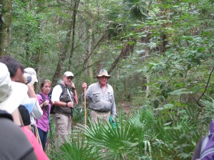
Panhandle residents explore the area of Aucilla Sinks with local guide David Ward.
Photo: Jed Dillard
Yes, the trail is maintained and marked by the Apalachee chapter of the Florida Trail Associations and there are bridges in spots, but the blood sucking bugs that bedeviled deSoto haven’t dissipated. More importantly, the spectacular and distinctive area provides a relatively easy hike that reveals the connections between geology and hydrology in an area with little disturbance by the settlers who followed the first Europeans into North Florida.
Hikers got up close and personal views of the Karst topography found in North Florida. This topography occurs as the tannic rivers and runoff dissolve the underlying limestone on their way to the aquifer. These connections and voids in the bedrock allow the Aucilla River to “come and go” above and below ground as it moves to the Gulf of Mexico as do all rivers in the Suwannee River Water Management District other than the Suwannee.
Native Jefferson county guide, David Ward pointed out the contrast between tannic water in the river channel and the clear water in caves near the river. “In those caves the water is crystal clear. You are looking at the water of the aquifer itself.”
Leon County agent Will Sheftall seized the opportunity to drive home how vulnerable Floridians are to ground water pollution and its effects on our water supply. “Here there’s little distance between the surface and the ground water. In these sandy soils, water moves quickly from the surface to the aquifer. Whatever is in that water can easily get into our ground water. Our personal activities and our public policies need to reflect that to ensure the future of Florida’s water quality.”
As we reached a slightly elevated area, Ward pointed out a longleaf pine/wiregrass community restored by reinstituting controlled burning. The open vegetation contrasts with the non-fire resistant species such as parsley hawthorn in wetter areas usually untouched by fire. “These pine savannahs were widespread when the Europeans arrived,” Ward noted. “Over my lifetime in these woods, I’ve seen appropriate management bring back these conditions closer to what we know it was like when the Europeans arrived.”

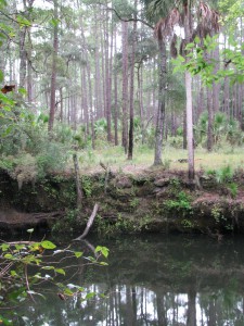
One of the many locations where the Aucilla River “rises from the limestone caverns beneath the earth.
Photo: Jed Dillard
Information on this section of the Florida Trail is available from the Apalachee Chapter of the Florida Trail Association, the Suwannee River Water Management District and Florida Fish and Wildlife Conservation Commission. Humidity never went below 80 percent during our late morning, early afternoon trip. November will likely provide less buggy and surely less muggy conditions. If you’d like to learn about this area from the comfort of your recliner or need some extra encouragement to strike out on the walk, check out this program previously broadcast by WFSU TV. http://wfsu.org/dimensions/viewvideo.php?num=184 Either way, you’ll know more about Florida’s spectacular natural world.
AUTHOR: Jed Dillard; Livestock and Forges Extension Agent; Jefferson County
- Rattlesnakes on Our Barrier Islands; Part 5 – Reproduction - January 12, 2026
- Rattlesnakes on Our Barrier Islands; Part 4 – Thermoregulation - December 29, 2025
- Rattlesnakes on Our Barrier Islands; Part 3 – Envenomation - December 22, 2025
