I think we can all agree it has been one crazy hurricane season. We have gone through the entire alphabet, and much of the Greek alphabet, naming storms – a record 30. Here in Pensacola we had Sally, but we had to prepare for many others that were wobbling around out there. It seemed this year the computer models were struggling predicting landfall locations. The “spaghetti” paths of the recent Eta were all over the Gulf. So, what is going on? It probably has to do with a warmer Gulf but there has to be more to it than that. Some have mentioned that it has been a La Nina year, and that the Gulf is more active during such years. Fair enough… what is the La Nina?
It is the opposite of the El Nino – a term more people have heard of. Okay… what is the El Nino?

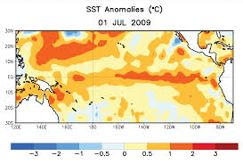
The red indicates warm water temperatures. Notice the warm temps in the eastern Pacific – not normal.
Graphic: NOAA
The El Nino is a warming trend observed in the eastern Pacific Ocean every 2-7 years around Christmas time. El Nino… “the child”. There are records of this event going back over a century. It was first noticed by Peruvian fishermen, who fish some of the most productive waters on the planet. These productive waters are fueled by the cold Humboldt Current and an upwelling bringing nutrient rich cold waters from the seafloor. When the El Nino occurs the Humboldt Current warms and “caps” the upwelling from reaching the surface where the food chain can benefit. The fish move away, and the fishermen notice it. When people began to colonize southern California, and began fishing for tuna and sardines, they noticed the same thing. The El Nino moved north of the equator just as it moves south of it.
To better understand this, we will need to know a little about the ocean currents.
The world rotates on its axis every 24 hours – there, we are off to a good start.
The sun’s rays hit the earth more directly in the equatorial part of the planet, making it warmer there.
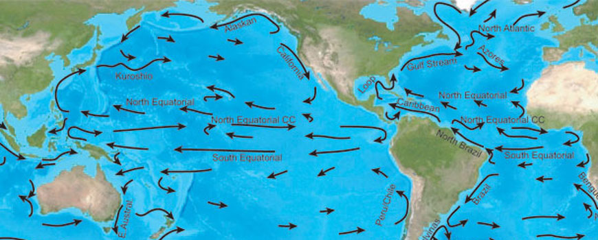
The cold polar water is more dense and sinks. The warmer equatorial waters move across the surface of the ocean to fill the void left by the sinking polar water. But it does not move in a straight line to that point. The world is turning remember, and this cause the moving water to bend in a curved pattern. The equatorial water moves west by northwest, warming more as it moves. This is the equatorial current. When it reaches Indonesia it is a balmy 80F+ (or so). This is the land of palm trees and coral reefs – “Bali-Hai”.
The water now moves north towards Japan and Korea before heading towards Alaska. Here it is called the Kuroshio Current and here it slowly begins to lose its warmth. As it slides beneath Alaska heading for Canada it is called the North Pacific Current, and then becomes the California Current as it passes the western United States heading back towards the equator. Here the water is much cooler (60-70F). There are no coral reefs, but you do find palm trees in southern California. This coast is also bathed with an upwelling and supports a rich fishery.
The southern Pacific is the same – but the current names are different. The equatorial current heads west reaching Indonesia and heads south to Australia where they call it the East Australian Current (the EAC of Finding Nemo fame). This is the home of the Great Barrier Reef. The currents circle near Antarctica, become colder, and head north along South America as the Humboldt Current (also known as the Peru Current).
Now imagine this…
Imagine the warm equatorial water near Indonesia begins to slide back towards California and Central America. Imagine this warm water layer then heads north and south to the coasts of California and Peru. This warm water caps the upwelling and the fish leave – near Christmas time – the El Nino. Bad times for the fishing fleet.
The atmosphere responds to these ocean temperature shifts. Normally, the cooler waters reaching the equator from California and Peru move westward forming the equatorial current. This cool water helps form east winds that move across westward as well. Known as the Trade Winds, sailors have used them for centuries to reach “good trading locations”. They are steady and dependable… unless it is an El Nino year. During El Nino the warmer ocean slows the strength of these winds. They actually move eastward across Central America and impact the Gulf of Mexico. During El Nino years these eastward moving Pacific winds push hurricanes out of the Gulf into the Atlantic. These are the hurricane seasons when Bermuda is hit frequently.
La Nina is the opposite. The Pacific waters moving into the equatorial area from California and Peru are colder than normal. These colder waters move faster and farther across the equatorial waters of the Pacific increasing the Trade Winds moving west… not east. With these Trade Winds moving in the direction they should, even stronger than normal, hurricanes are “sucked” into the Gulf of Mexico. La Nina seasons are very busy hurricane seasons for us. And you guessed it, it is a La Nina year. La Nina usually follows the El Nino and we can sometimes experience them for two seasons, but 12 months is typical.
The thing is La Nina’s have been occurring for centuries. We have certainly had hurricane seasons that were busier than normal but not to the extent we saw this year. You have to look at climate change in general, and other atmospheric conditions that could influence this. I am sure the meteorologists and climatologists are as interested in what happened (is happening) this year as we are.
Hopefully we will not see another season like this for some time.
Happy Thanksgiving.
- Rattlesnakes on Our Barrier Islands; Part 5 – Reproduction - January 12, 2026
- Rattlesnakes on Our Barrier Islands; Part 4 – Thermoregulation - December 29, 2025
- Rattlesnakes on Our Barrier Islands; Part 3 – Envenomation - December 22, 2025


