ARE YOU AWARE THAT GIANT SALVINIA HAS BEEN FOUND IN THE FLORIDA PANHANDLE?
Most likely not.
The number of reports in the entire of Florida are very few. So, unless you live near one of the infested areas you are most likely not aware of this invasive plant.
This is an EDRR species with reason for concern.
The first record of this plant in the Pensacola area was in 2018. I was called to a local residence to discuss a possible living shoreline when we observed giant salvinia (Salvinia molesta) floating on the west arm of Bayou Chico. Further investigation found the plant inhabiting the north arm of Bayou Chico as well as the Jackson Lake area. Though not reported on EDDMapS, we now know the plant has moved into the retention pond at nearby Lexington Terrace. There are currently nine records of this plant in that area, but we know that the plant covers much of that waterbody.
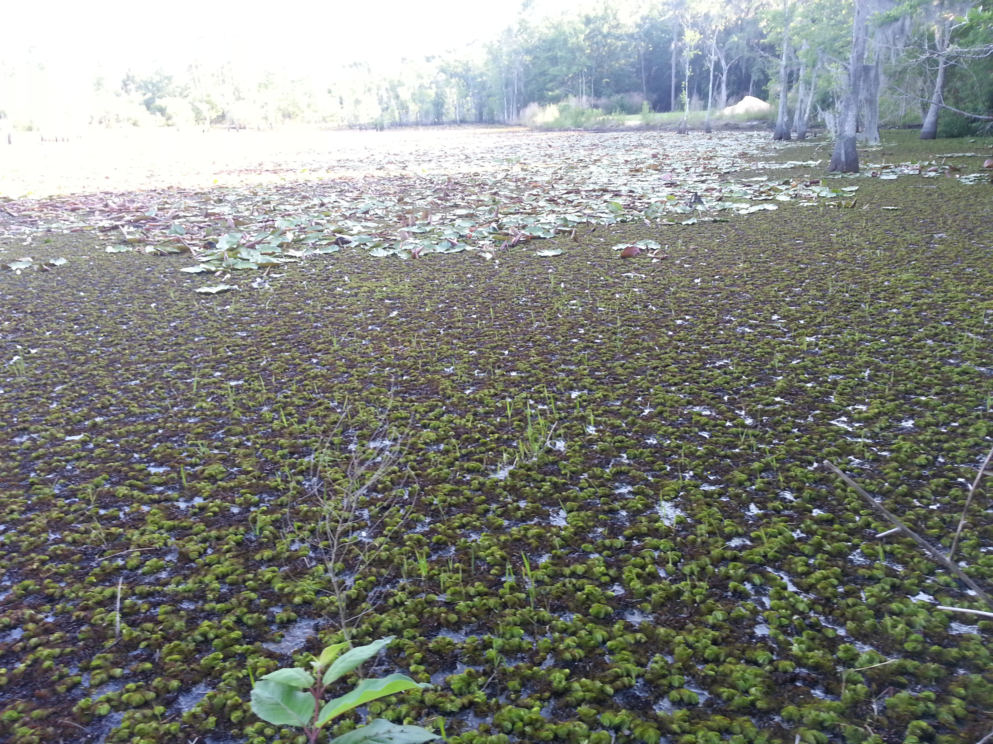
Active growing Giant Salvinia was observed growing out of the pond water on to moist soils and emerging cypress and tupelo tree trunks. Photo by L. Scott Jackson
At that time, I checked EDDMapS for other records in Florida. There was a report from Bay and one from Gadsden Counties. I did note that there were large infestations in Louisiana and Texas. There were also posts and videos from Texas explaining the bad situation they had and how residents there could help. The concern was so high from those states that the Florida Fish and Wildlife Conservation Commission formed a small team, based out of Bay County, to battle this plant and reduce its chance of spreading here. A true EDRR effort. That team is very present in Escambia County with constant survey and treatment projects ongoing.
A couple of years ago I was heading out west to camp. Our first stop was at Lake Bistineau near Shreveport LA. After setting up camp we walked down to the lake and witnessed a lake completely covered with small floating plants. No water could be seen. I did see a floating screen holding the floating plant outside of the swimming area. We walked onto a dock set up for fishing but there was no way you could fish there. The plant was so thick it would be impossible to get your bait below the surface. Then it hit me… this was giant salvinia – the plant FWC and local counties were working on controlling. I could see firsthand what would happen if we did nothing. From the dock I walked over to the swimming area and found a sign informing everyone about the potential threat of this plant and to be very careful NOT to take it with you to another area of the lake, or another body of water. After returning home, I worked with our county to educate the public about this plant, how to identify, report, and manage it.
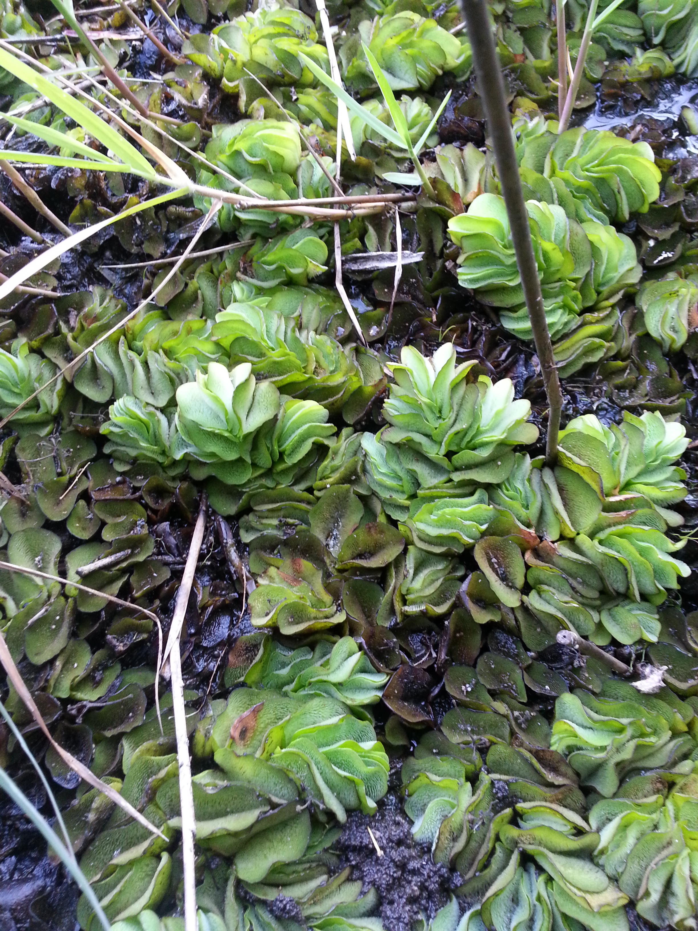
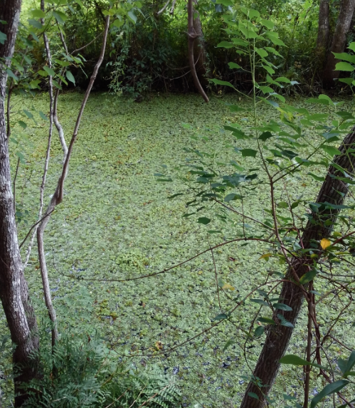
Giant salvinia overgrowth in a backwater section of Bayou Chico in Escambia County. Photo credit: Escambia County Natural Resource Management
Giant salvinia is originally from Brazil and Argentina. It resembles our native duckweed but the leaves are larger – 0.5-1.0 inches long. It was intentionally brought here as an aquatic ornamental plant. It prefers freshwater with little or no movement and high in nutrients. We already mentioned how it can impede fishing and swimming – but it also blocks sunlight needed for submerged grasses and, during decomposition, can lower the dissolved oxygen within the water to levels lethal to fish and invertebrates.
The nine records in Pensacola, one in Panama City, and one in near Quincy have now been joined by 12 other records in Florida. Nine are in Jacksonville, two near Naples, and one near Lakeland. It has also been reported in South Carolina, Georgia, Alabama, Mississippi, Louisiana, Texas, and the California/Arizona state line.
This is not a plant we want to spread across our state, EDRR is very important here.
What can you do to help?
Report any possible sighting to your local county extension office. If you are not sure if it is the plant – report anyway, someone will come out to verify the identification.
If it is small patches, remove from the water using a crab net, or swimming pool skimmer, place the plant out in the yard in direct sunlight to dry and kill it. It can then be double bagged and thrown in the trash.
If there are large areas covered with the plant, again, contact your county extension office who will connect with the FWC team to begin treatments.
As always, if you have any questions about this, or any other invasive species, contact your county extension office.
WERE YOU AWARE THAT THE INVASIVE CUBAN TREEFROG HAS MADE IT TO THE FLORIDA PANHANDLE?
Maybe…
Some of you have been following this story in this newsletter, some of you may have attended our workshop in Panama City in September of 2023 (where we caught three of them), and some of you may have found the frog on your property. But some of you may be unaware this common invasive animal from central and south Florida has been found here. Well… it has.
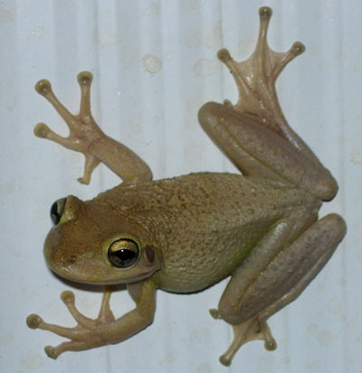
The Cuban treefrog (Osteopilus septentrionalis) is native to Cuban, and other Caribbean Islands, and arrived in Florida in the early part of the 20th century – most likely as a hitchhiker on a container or cargo boat. From there they have dispersed across the Florida peninsula where they have been established for several decades now.
Cuban Treefrog.
Photo by: Dr. Steve Johnson
There are several issues with this non-native frog. For one, there are environmental impacts. They are large treefrogs and prey on many of our native species. There is evidence of the decline of native frogs due to their presence – and this includes predation of Cuban treefrog tadpoles on native frog tadpoles. Their skin produces a mild toxin that has not stopped native frog predators from consuming them, but appears they are less nutritious and may be avoided. There is also evidence they may have introduced new diseases and parasites that are impacting native amphibians.
Two, there are negative impacts on humans – our quality of life. One issue is sheer number. Our homes provide many places for them to hide, and food to eat. As they out compete, or consume, the native frogs, they quickly increase in numbers to the point where they are a nuisance. Lots of feeding frogs produce a lot of frog feces, which can leave an unsightly mess all over the house. Unlike many of our native frogs, they have no problem entering our homes. The high numbers gathered around the porch light near the front door – an open door is easy access for them. They have also accessed homes via the vent pipe for the bathroom. Many have opened the lid of their toilet to find a large treefrog sitting, or swimming, there. Large numbers of frogs also mean large numbers of singing males, and they prefer to call just before dawn – annoying many homeowners. Add to this the toxin it produces in its skin. Though not lethal it is very irritating to the eyes and nose and can cause seizures in pets who may grab one. They have been known to hide in electric panels on the outside of homes and cause short circuits to electrical systems.
The first I heard of a Cuban treefrog in the Florida panhandle was a colony near Tyndall AFB in Bay County. It was later verified that they were breeding. There had been other one-off reports of them, but this indicated that they could tolerate our colder winters – though our winters have been mild in recent years. There were further reports from Okaloosa County, Santa Rosa County, and Escambia County. EDDMapS now lists at least one record in every panhandle county except Holmes, Washington, and Liberty. It is believed the common method of introduction is hitchhiking on trucks delivering plants, or other products, coming from south Florida. It is very likely that the frogs are in those three counties and have not been reported.
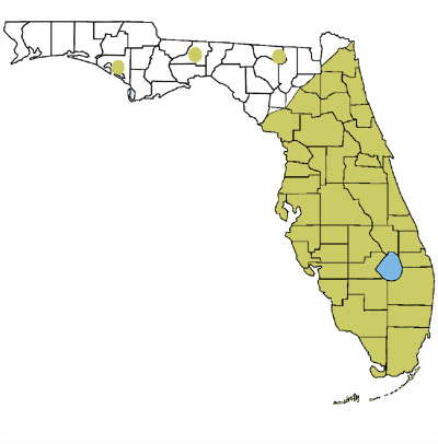
Range of Cuban treefrog
HOW CAN I TELL A CUBAN TREEFROG FROM OUR NATIVE FROGS?
First, it is a treefrog. This means that it has enlarged toe pads for climbing trees and sticking to the sides of buildings. Treefrogs tend to feed at night and are often seen on houses near exterior lights where insects gather. During the day they will hunker down in shrubs and trees. If you have them, you will most likely see them on the side of your home at night.
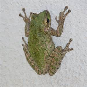
Cuban Treefrog
Photo: UF IFAS
Second, they are much larger than our native treefrogs. Most of our native treefrogs do not grow longer than three inches, Cuban treefrogs can reach lengths up to six inches. So, a large treefrog is most likely one.
Third, they can appear in a variety of colors. Green, gray, brown, and even white individuals can be found. But they have warty skin. Many native treefrogs have smooth skin. Some have granular skin that may appear warty – but Cuban treefrogs are warty.
NOTE: Cuban treefrogs will NOT have warty skin covering the head. The small native cricket frogs, who also have warty skin and do have warts on head area. Check notes on young treefrogs below.
Fourth, they have a yellow color under their armpits and in the groin area.
Fifth, with larger Cuban treefrogs, the skin will be fused to the skull.
Young Cuban treefrogs – those within the size range of our native frogs, have bluish colored leg bones when viewed from the belly side. They also have large red “bug eyes” and a yellow stripe extending from their eye (not the lip) to the rear leg.
This is an EDRR species in the Florida panhandle currently. We are not sure where on the invasive species curve their populations currently lie, but a rapid response is in order for this species.
To verify identification and advice on managing, contact your county extension office. If you are in the Pensacola area, we will be holding a workshop on this topic April 25, 2024 at the Escambia County Extension Office. We will be providing PVC treefrog traps to help capture them. If interested contact Rick O’Connor at 850-475-5230 ext.1111, or email roc1@ufl.edu.
ARE YOU AWARE THAT THE INVASIVE COGONGRASS HAS MADE ITS WAY TO OUR COASTAL AREA?
Many may be familiar with this noxious weed but that is because it has been a problem in agricultural and timber lands for many decades now.
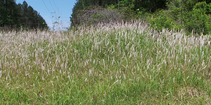
Cogongrass seedheads are easily spotted in spring.
Photo credit: Mark Mauldin
This grass (Imperata cylindrica) is native to Southeast Asia and arrived by accident within cargo delivered to the port of Mobile in the early part of the 20th century. It quickly spread and has been a menace ever since. It can be found in ditches, roadsides, empty lots, golf courses, pastures, and timberlands. On a recent drive south through Mobile County there was nowhere the plant could not be found. The current records on EDDMapS shows the plant has spread through nine states in the southeastern U.S. and every county in Florida. Cogongrass has serrated edges and is imbedded with silica, so is not a popular forage plant with many forms of livestock and wildlife. It burns very hot and has made land management with prescribe fire difficult. States across the south spend hundreds of thousands of dollars annually trying to control the plant. Though working primarily in Santa Rosa and Okaloosa counties of the Florida panhandle, the Longleaf Alliance has a team focused on managing it.
My role with UF IFAS Extension is with Florida Sea Grant, I focus on coastal issues. A couple of years ago, we received a call from a condo manager on Perdido Key who believed they had found cogongrass growing on their property. I, along with natural resource personnel from Escambia County, made a site visit and sure enough – there was cogongrass growing around their swimming pool. It most likely got there by the lawn maintenance crew. This is a common method of spreading this plant. Crews mow the grass down, do not clean their equipment, load it on a trailer, and spread the plant to other locations. However it got there, this was a classic EDRR situation on our islands and plans were made to remove the plant without harming the native sea oats nearby.
Cogongrass, like beach vitex, is allelopathic – it can draw moisture away from nearby plants, killing them, and taking over their space. The plant can grow into thick monocultures displacing the native dune plants and altering the ecology – possibly impacting the federal protected Perdido Key beach mouse. It is a relatively new issue on our barrier islands. The current EDDMapS records show the plant has been found on Horn Island and Petiti Bois Island in Mississippi – Dauphin Island, Ft. Morgan peninsula, and Gulf Shores in Alabama – Perdido Key, Santa Rosa Island, Destin, south Walton, St. Andrew’s State Park, Tyndall AFB, Cape San Blas, St. Vincent Island, Apalachicola, and the St. Marks Wildlife Refuge in the Florida panhandle. This is most likely under reported and notes that the invasion of the coastal areas has begun. A rapid response is needed.
IF I LIVE IN A COASTAL AREA, HOW WOULD I KNOW IF THERE IS COGONGRASS PRESENT?
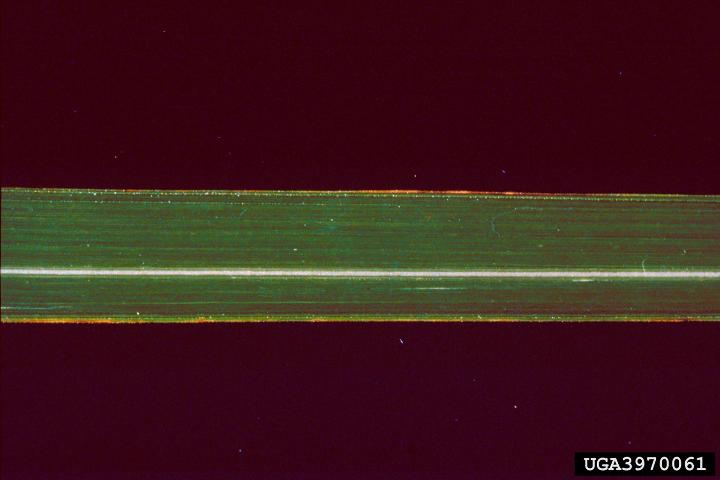
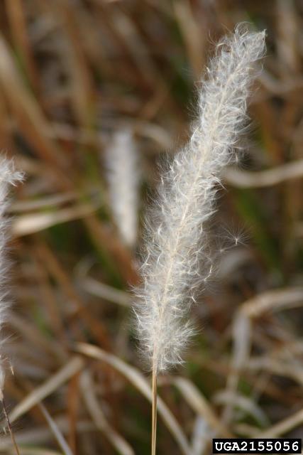
First it is a grass. It resembles typical turf grass, but the blades are tall – up to three feet high – and the blades are between 0.5-1.0 inches wide. It has a lighter green color than most of the native plants but does become brown in colder weather. It is usually found in very dense patches and looks “invasive” – like it is taking over the landscape. Close inspection of the blades you will find the edges rough (serrated) and the “veins” all running parallel (not branching) with the darker midline not in the middle of the blade but offset to one side. When the grass goes to seed in the spring it can be identified by the white “fluffy” seeds that extend above the grass and are dispersed by the wind – much like dandelions.
The midline vein of cogongrass is off-center.
Photo: UF IFAS The white tufted seeds of cogongrass.
Photo: University of Georgia
Managing this plant is very difficult. Fragments of the rhizomes can generate re-growth and removing all of the rhizomes by hand is very difficult. Herbicide treatment is the most effective and the grass tends to return even with this. The best time to apply herbicide is in the fall.
If you think you may have this grass, contact your county extension office to verify and for advice on how to manage.
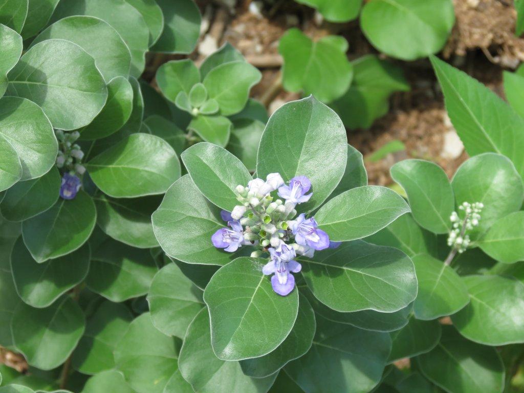
ARE YOU AWARE OF THE INVASIVE DUNE PLANT CALLED BEACH VITEX?
I would say most are not. Though the plant was known over a decade ago, the education/outreach on this species has not been equal to the effort of lionfish.
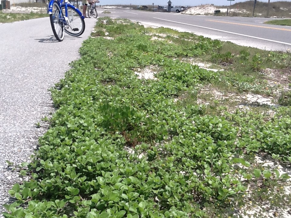
Vitex beginning to take over bike path on Pensacola Beach. Photo credit: Rick O’Connor
In 2012 I was contacted by a Gulf Breeze resident who had the invasive vine – beach vitex (Vitex rotundifolia) growing on her property. They told me that had it under control but felt it was coming from Pensacola Beach. I checked the EDDMapS database and found only three records of the plant in the state of Florida. Two were in Jacksonville and one was on Pensacola Beach. So, I went to investigate.
It was there… and it was pretty bad. The front yard was about 25% covered with the plant but a side yard and the back yard were 100% covered. I surveyed other parts of Pensacola Beach and found the plant in other locations. If you remember from Part 1 of this series, if you cannot prevent the invasive species from reaching your location, the next thing is Early Detection Rapid Response (EDRR). This was definitely an EDRR species. We needed to get on top of this as soon as possible.
In 2013 I conducted a survey of Pensacola Beach on my bicycle. I found eight more locations that had the plant. They were all on private property. I asked the homeowners if they knew how the plant got there. Some replied that they had planted it. Others said that they had hired a landscaper, and this was the plant they had chosen. Others had no idea where it came from. At the time, beach vitex was not listed as an invasive species in Florida. It is now and is also listed as a Florida noxious weed (you can no longer sell it). It was time for a Rapid Response – education about the plant, its invasiveness, and how to manage.
Beach vitex is native to the Pacific coast of Asia. There, it grows in coastal areas where there is plenty of open sunlight and well drained soils. It was brought to the U.S. as a possible ornamental plant in the 1950s. There are no records of what happened to those initial plants, but a second wave was brought to North Carolina in the 1980s. They decided to use the plant in dune restoration after a hurricane and that is when it “raised its ugly head”.
Beach vitex is allelopathic – it releases compounds that pull water away from the native plants causing their death – vitex then takes over the newly empty space – spreading across the beach. The plant has a taproot from which extend vines that run across the surface of the sand in almost a 360° pattern. It begins as a soft herbaceous vine, but with time, becomes woody and larger in diameter. It will eventually grow vertical and become more of a shrub. In the Carolina’s it took over the dune systems forming a thick monoculture resembling kudzu – giving it their local name “beach kudzu”. During the summer months the vines can grow very quickly – up to 20 feet in one week – covering the landscape. At the time they were concerned this would impact sea turtle nesting, now there is evidence that it has. It also impacted a state listed dune plant they were trying to protect. North and South Carolina formed a state task force to battle the plant and have spent hundreds of thousands of dollars doing so. When we first posted we had found it on Pensacola Beach I was contacted by the Carolina Task Force and advised to get rid of it as quickly as possible.
My most recent survey was conducted in the fall of 2023. Currently the plant has been found at 100 sites.
61 of these are on Pensacola Beach. 57 (93%) are east of Casino Beach and 32 of those (56%) are north of Via DeLuna Blvd.
25 are within Gulf Islands National Seashore and 24 of those are at Naval Live Oaks.
7 sites at Navarre with 6 of those on Navarre Beach.
3 sites are in Gulf Breeze proper.
2 sites are on Perdido Bay.
2 sites are on Perdido Key.
At this time 74 of the 100 sites have been treated or removed.
36 of those 74 sites (49%) the plant has not returned. Treatment continues on the other 38 sites.
39 of the 61 sites on Pensacola Beach are private property, and it is up to the homeowner to manage the plant. Florida Sea Grant continues to hold community events to manage the 9 public sites on Pensacola Beach.
The most recent EDDMapS database shows that beach vitex occurs in two other panhandle counties. These include Okaloosa and Franklin. It is very possible they occur in others, but surveys have not been conducted.
Methods of managing this plant vary. Small, individual plants can be successfully removed by hand with no regrowth. Small patches can be removed to the taproots and those can be spot sprayed with herbicide. Large patches are very difficult to remove by hand and herbicides are recommended.
If you have questions as to whether or not you have beach vitex in your area, or need advice on how to manage it, contact your county extension office. It is EDRR time.
When the red lionfish (Pterois volitans) first began to appear along the shores of the Florida panhandle there was a great effort to make locals aware of the potential problem. Today it is rare to find people who do not know what a lionfish is. I was recently working with a group of elementary school students in the beach classroom at the school districts environmental center. There was a tank with a lionfish in it and as I approached, they all yelled out – “that’s a lionfish”. They were all aware of this invasive species.
Red Lionfish
Photo: Florida Sea Grant
The first record of lionfish in the northern Gulf of Mexico was logged in 2010 – though a presentation at our recent panhandle lionfish workshop suggested it may have been here as early as 2008. There was immediate concern from the fishing and diving community. We began to hold workshops and local non-profits formed to begin removal tournaments. The word on the aggressive spread, fast reproductive rate, and lack of predators sent an alarm across the region.
In 2013 we held our 1st panhandle regional lionfish workshop. Researchers indicated that the densities of lionfish off our shores were the highest in the south Atlantic region – a presentation at the recent workshop indicated, at that time, the density of lionfish here may have been the highest in the world. It was not uncommon to see videos of small artificial reefs with 100 or more lionfish hanging about. It was reported that they were opportunistic feeders and had identified no fewer than 70 species of small reef fishes in their guts. The reproductive rates were an average of 30,000 fertilized eggs every four days – basically year-round. Their eggs drifted in a gelatinous sac and the spread of the fish followed the ocean currents, spreading everywhere.
War was declared.
Lionfish tournaments began to pop everywhere. They began with a few hundred or a thousand lionfish turned into events where tens of thousands of lionfish were weighed during three-day events. Lionfish education and outreach expanded across the state. Some engaged in the commercial harvest of these fish. Turned out they were quite tasty. Knowing Pensacola was sort of ground zero for lionfish density – I was contacted by chefs from around the region seeking fillets.
At the 2019 workshop researchers reported that the densities had declined in waters less than 200 feet. Everyone pointed at the recreational and commercial harvest as a possible cause, but something was obviously working. Lionfish were beginning to develop skin lesions. Scientists were not sure of the cause, and not sure whether this played a role in the density declines, but it was happening. Harvesters reported problems on the commercial side. Dive time and location were becoming problems, densities were declining – less fish to harvest, and the price point between the harvesters and the seafood industry were not where either side wanted them. One thing that seemed to be working was ecotourism. Word about huge numbers of lionfish was drawing visiting divers from all over. Dive charters were finding they could make more money but taking visitors out to shoot lionfish, than selling them to the commercial markets. There was also a supply issue. One restaurant from Charleston South Carolina contacted me asking for a source of lionfish. He said he needed about 500 pounds a week. This order would be very difficult to fill. But things from the invasive side, at least in waters less than 200 feet, seemed to be improving.
We just held the 3rd regional workshop in 2024. Researchers indicated that the densities were still down. Anecdotal reports suggest an increase in lionfish. It was thought that the pandemic reduced tournaments and commercial harvest and populations of lionfish were on the rise again. This may very well may be, but science did not show this. More studies were needed. Skin lesions are still occurring, but researchers are still not sure what is causing it. There does seem to be a link between the decline in density and the frequency of these lesions – the researchers believe that these lesions are playing at least a part in controlling their population.
One researcher reported evidence of lionfish in our estuaries. Using eDNA methods she was able to identify lionfish DNA in the upper portions of Escambia, Blackwater, Perdido, and Mobile Bays. The monitoring was done during low tide to reduce the chance of tides moving the eDNA up into the bay. She also found evidence of lionfish DNA in the feces of shorebirds nesting on our barrier islands. They are still working out how this is happening, possibly the birds are feeding on newly hatched lionfish from the drifting egg mass – not sure. But it is very interesting.
The commercial harvest is doing okay in some parts of the panhandle, but not in others. Interviewing restaurants and seafood markets we found several barriers keeping some of these businesses from providing lionfish. First was the size of the fish and percent yield of fillet. Lionfish are small and labor intensive to prepare. A second concern was the venomous spines. There were also concerns about supply and price points. However, all the seafood markets and restaurants we spoke with were interested in selling lionfish if we could overcome these barriers and were very open to the idea of education/meetings on how to do so. Florida Sea Grant does plan to begin these meetings this year.
The tournaments continue to do well. Destin’s Emerald Coast Classic is now the largest lionfish tournament in the world. Interest and participation continue to be strong. Florida Fish and Wildlife Conservation Commission’s Lionfish Challenge is also doing well, though they reported a decline in the number of commercial harvesters participating.
So as of now
Lionfish remain in the Gulf of Mexico
Densities are still low
Lesions are still occurring
Commercial harvest has not gone as well as hoped
Tournaments are doing well
Lionfish appear to be moving into the estuaries
We will see what updates the 2029 workshop will add to the story.