by Rick O'Connor | Sep 2, 2016
Going along with the International Coastal Clean Up, UF/IFAS Extension will be promoting September as Microplastics Awareness month.

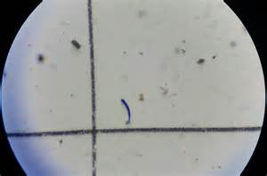
The most common form of microplastic are fibers.
Photo: UF IFAS St. johns County
If you have not heard, microplastics are small pieces of plastic < 5mm in diameter. Some are fragments from larger pieces of plastic that have been broken down by the elements, others are produced at that size to be used in products such as stuffed animals or melted in molds to produce larger products. Some microplastics are small beads used in cosmetics, but the most common are fibers from our linens and clothing. These fibers are removed during washing and travel through the drain and sewer systems until the reach the sea. Either way – they end up in our coastal waterways where they have had some negative impacts on marine life.
Some impacts include:
- Consumption by plankton give the sensation of being full – thus they stop eating.
- A decrease in the reproductive success of oysters.
- Negative impacts on hatching rates and activity rates of some species of larval fish, making them more prone to predation.
- They have also been found to be more common in sea salt and have been found in the guts of some fish and bivalves sold at seafood markets on the west coast. We are not sure of the impact of human consumption of these products.
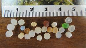
Small microbeads called “nurdles” are used to fill stuffed animals and to make larger plastic products.
Photo: UF IFAS St. Johns County
During the month of September, we will be posting short articles on our Facebook pages and on Panhandle Outdoors. Extension will also host a webinar on the topic September 16. It will be broadcast from 12:15 to 1:00 PM EDT. To register for this webinar go to https://www.eventbrite.com/e/whats-the-big-deal-with-microplastics-webinar-tickets-27070847634. Please like and share these with your friends so that we can make more people aware of this problem. If you would like to have a public presentation on microplastics, contact your county Extension office. Check in on these posts throughout the month.
http://facebook.com/NEFLSeaGrant
https://www.facebook.com/MicroplasticAwarenessProject
www.plasticaware.org
by Rick O'Connor | Aug 26, 2016
It is August, we are just off another successful Sea Turtle Baby Shower event in the Pensacola area, and we are in peak season for sea turtle hatching. Those little guys have a tough road to follow trying to emerge from their nest to reach the open waters of the Gulf of Mexico. Within the nest the young wait for cooler temperatures and no vibrations to begin their climb towards the surface. Once they have emerged, they locate the shortwave light of the moon and stars reflecting off of the water and head for sea. However, ghost crabs, fox, and coyotes, all excavate nests and consume hatchlings running across the sand.
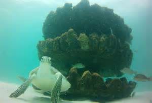
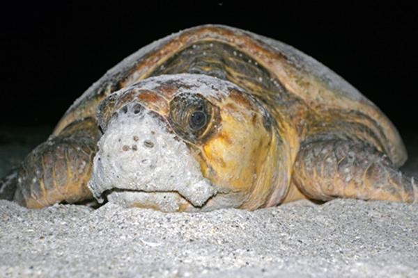
This sea turtle frequents the nearshore snorkel reef at Park East in Escambia County.
Photo: Robert Turpin
But these predators are not alone on Pensacola Beach. Humans have moved onto the island in large numbers. Vehicle tracks, large holes, tents, chairs, and our pets all are obstacles for the young in their journey to the sea. One of the larger problem has been lighting. Most of our buildings are well lit for safety. We tend to use shortwave lighting systems that produce bright white lights similar to what the moon and stars reflect off of the Gulf – many times brighter. Because of this many of the hatchlings will disorient and travel towards the buildings and roads instead of the open Gulf… this certainly is not good. Disoriented turtles will wonder onto road ways where they are hit by cars, and under or around buildings where they can become lost or come in contact with house pets and rats – not to mention the increase time on land will increase the chance of a native predator finding them. If they make it until morning, there is the problem of shorebirds and the sun – the chances of the hatchlings surviving a disorientation are not good.
There are a variety of reasons why sea turtle populations are low enough to have them listed, but this is certain one of the larger problems. Data from Escambia County extending back to 1996 show that, on average, 48% of the sea turtle nests disorient – and it has been as high as 70%.
So What Can We Do to Help the 2017 hatchlings?
First, we are having a big year for nesting. Mark Nicholas, GINS and permit holder for sea turtle work here, indicated there were 101 nests in our area this year… we have a chance to have a really big and successful sea turtle nesting season – with a little help from you.
- Clean the beach before you head in for the night. Most panhandle counties actually have a “Leave No Trace” ordinance which requires the removal of chairs, tents, etc. – but be sure the holes are filled in and the trash is removed as well.
- For inside lighting – turn down the lights and/or close the currents. Exterior lighting should be “turtle friendly” – meaning long wavelength – which means yellow/red. Most panhandle counties have an ordinance for exterior lighting. In Escambia County residents have until 2018 to comply – but we encourage you to make those changes as soon as you can to help the turtles hatching this season. “Turtle Friendly” would include the big three – KEEP IT LOW, KEEP IT LONG, AND KEEP IT SHIELDED. Keep it low meaning as low to the ground as you can. If that is not possible, place a shield on the fixture to direct the light down to where you are walking and not out to the beach. Keep it long refers to the wavelength, longer than 560 nanometers, which is in the yellow/red range of color. Studies show that hatchlings are attracted to the shortwaves (white/blue) end of the spectrum. Having long wave lighting will increase the chances of the hatchling finding the shortwaves from stars off of the Gulf. You will want to keep the illumination down as well. We recommend 25W bulbs, which is bright enough to see and reduces the chance of attracting a young turtle.
- Keep a distance from the marked nests – remember that vibrations (even from your walking) can cause the hatchlings to wait – and waiting too long can cost them their lives. If you are lucky enough to see baby turtles crawling for the Gulf – do not use flash photography and do not use flash lights – unless they have a protective red film producing a low intensity red light.
- If you find a group of hatchlings that are obviously disoriented, contact the local authority in your area. In Escambia County we recommend calling the sheriff substation on the island or the Gulf Breeze dispatch – who will contact the National Park.
If you have questions about turtle lighting options, the current county ordinances designed to help island wildlife, or the Turtle Friendly Beaches program, contact your County Extension Sea Grant Agent.
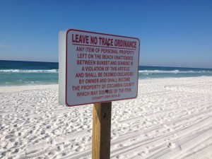
Many counties in the panhandle have lighting and barrier ordinances to protect wildlife and workers.
Photo: Rick O’Connor
by Rick O'Connor | Aug 26, 2016
MAN do folks in the Florida panhandle like scallops. I recently visited boat ramps at Steinhatchee and Keaton Beach (in the Big Bend) and the parking lots were full of trucks and boat trailers belonging to people combing the grassbeds of the Gulf searching for this popular bivalve. Scalloping is a fun activity that gets the whole family outside snorkeling and finding all sorts of local marine life. And scallops taste good… their sweet meat broiled in butter is a real Florida panhandle treat. Many locals remember years ago collecting scallops with family and friends in Pensacola Bay area …. Good times!

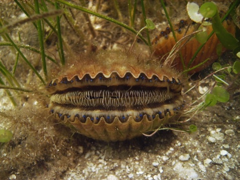
Bay Scallop Argopecten iradians
http://myfwc.com/fishing/saltwater/recreational/bay-scallops/
But that was another time. Scallop populations have declined across Florida’s Gulf coast. Today commercial harvesting is banned and recreational harvest is limited to the Big Bend area between the Bay/Gulf and the Hernando/Pasco county lines (visit map). Within this area there is a seasonal limit, bag limit, and harvesting equipment limits. The season runs from Jun 25 – Sep 24 (except in Gulf County). Harvesters can collect 2 gallons whole (or 1 pint cleaned) / person / day. There is a maximum of 10 gallons whole / vessel / day. You can collect by hand or using a dip net. All harvesters are required to have a Florida saltwater fishing license unless (a) they are exempt from such a license, or (b) they are wading nearshore and their feet do not leave the bottom (no swimming or snorkeling). For 2016 the regulations for Gulf County have changed, please visit the above link at FWC for those changes. BUT wouldn’t it be great to be able to scallop in the Pensacola Bay area again?
County Extension Sea Grant Agents have been working with the Florida Fish and Wildlife Conservation Commission surveying Gulf coast bays that once had scallop populations – including Pensacola Bay. The purpose is to determine the status of these animals at the moment. Scallops are mass spawners and need a relatively high density of individuals in order for reproduction to be successful. The state could easily “re-seed” these areas with scallops to increase the density but their populations declined for a reason. Was it water quality? Loss of habitat? Heavy predation (human or marine life)? Or a combination? We are not sure… but a re-seeding project will not be successful until it can be determined that the stresses that caused the reduction have improved enough that the scallop will survive.
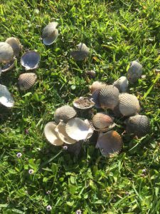
A pile of cleaned scallops found in a parking lot on Pensacola Bay. Harvesting scallop in Pensacola Bay is illegal.
Photo: Rick O’Connor
On that note, Santa Rosa and Escambia County Extension Sea Grant Agents recently held two scallop surveys; one in Santa Rosa Sound and one in Big Lagoon. The morning of our Santa Rosa Sound survey we found a pile of cleaned scallops in the parking lot of Shoreline Park (approximately 35 scallops). This is a good sign in that it suggests scallops are trying to make a comeback here. It is bad in that they were harvested. Many in our community are not aware that harvesting scallops in Pensacola Bay is illegal. No recreational or commercial harvest of bay scallop is allowed, even during scallop season, west of the Gulf County/Bay County line (Mexico Beach). If you are out paddling around our grass beds and find live scallop please let your county Sea Grant Agent know, but also remember that you are not allowed to harvest them. Hopefully one day we will be able to tell you that yes you can, but until then we need to give them a chance to spawn and see if our grassbeds, and water quality, are sufficient enough for them to return.
by Rick O'Connor | Aug 12, 2016
Yea… should we? Probably your next question would be – can we?
The answer is… maybe
There was an interesting article in the June edition of the Smithsonian magazine. It discussed this question. Science is close to being able to eliminate mosquitos… sort of… there is more to it… but it brings up an interesting question – should man be allowed to eliminate a species from history? Some would say – “well, it’s not the first time we have done this… so why not?”. Others would say “this is not correct… we should not be the ones to decide which species are allowed to exist and which are not.” But there is more to the story…
There are about 3,500 species of mosquito known to science, about 100 of these are known vectors for human diseases. 725,000 human deaths are caused by mosquito borne diseases each year. The Smithsonian article quotes other wildlife induced human deaths for comparison. Between 20,000 and 200,000 die from parasites transmitted by freshwater snails, between 44,000 and 125,000 die from snake bite, between 55,000 and 60,000 from dog bites, and 6 from sharks (another testament that sharks are not the threat most people think they are), but almost three quarters of a million humans die each year to mosquito bites is significant… should we consider eliminating them?
Anopheles gambiae is the mosquito that transmits malaria.
Photo: UF IFAS
Dr. Andrea Crisanti, research scientist at Imperial College in London, has spent most of his life trying to end malaria – he would like to see it eliminated. Malaria alone killed 400,000 people in sub-Sahara Africa in 2015. The protozoan that causes malaria is transmitted by the mosquito known as Anopheles gambiae. He, and other scientists, have developed independently – the different pieces of a method that may eliminate this species of mosquito. It is basically a gene therapy method. They insert a lethal gene into the DNA of the mosquito, release it into the environment, mating ensues, death occurs, species is illuminated.
Now comes the maybe part…
This type of technology has been used to develop a variety of corn that produces its own pesticide. However, the pollination part is done within a controlled lab and the plants are planted in the fields. This would require successful breeding within the environment… it might work. The other issue is that this method is species specific. Would another species adapt and begin to transmit the malaria protozoan? And, of course, there is the question of unforeseen consequences. Because mosquitos do not travel far from where they were born, most researchers do not think this method would eliminate a species on a global scale – but rather on a local one. Scientists have been able to sterilize mosquitos using gamma radiation. Reducing an entire population has had mixed results. They are currently working on a non-radiation method for the Asian Tiger Mosquito (Aedes albopictus), one of the local vectors for Zika.
Researchers are currently targeting three species of mosquito for this project. Anopheles gambiae (the carrier of malaria), Aedes aegyptie (the carrier of yellow fever, and possibly Zika), and Culex (which carries west nile and others). But the questions still lie out there – (1) will it work?, (2) are there other consequences?, (3) is eliminating a species ethical?
There are many scientists who think it is okay. Dr. E.O. Wilson stated Anopheles gambiae can go. Many others are concerned about upsetting the ecology of a system by removing a food source. Ecologists state that it could impact the balance of the tundra ecosystem, where mosquitos are a major food source for many of the local birds. But in other locations, the mosquito predators will find other species of mosquitos (or other food in general), and that this would not impact the system. Other scientists say no… we should not. One mentioned he did not want to be part of eliminating a species from the planet, it is not our role. Others are concerned with which species would be next? Where will this stop? And there is always the chance that biological weapons can be developed with this technology.
It is an interesting question.
by Rick O'Connor | Jul 31, 2016
On a recent camping trip out west I was made aware of just how valuable water is. The American west has been battling water issues for a few years now. Some camp showers had buttons that would provide you water for a couple of minutes, others charged $.50 for four minutes, some charged $1.00 for four minutes. Not one campsite had water available at the site. You had to walk, load your container, and return. This forced you to be a little wiser on how you used it. You did not want to have to go back and get more very often.
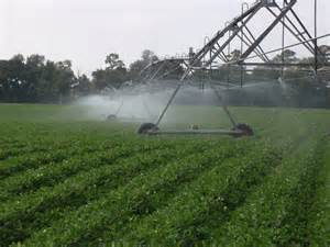
The Bill Young Reservoir in south Florida.
Photo: Southwest Florida Water Management District
However, I was troubled by some of the things I saw as I traveled through the southwest. Areas in the desert where farmers were trying to grow row crops, citrus, and pecans – irrigation systems set up everywhere, reservoirs with canals and dikes to feed much needed water to the farmers… and signs in town where you could buy water to drink at $.25/gallon. It seemed an inefficient use of this resource. It would make more sense to grow crops that used less water, maybe… no water. Recently we have heard a lot about “water wars” and “water rights” in the American southwest. Farmers seeking more, municipalities trying to grab their piece of the pie, football fields and golf courses, and even camp grounds. Some locations you cannot wash your car, or your dogs. It is a real dilemma they are facing. There were numerous creeks and streams I drove over that were absolutely dry, cattle in open rangeland seeking anywhere to find something to drink.
Could this happen in Northwest Florida?
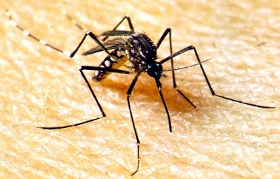
You would think not. In the book Mirage by Cynthia Barnett, it mentions a comment made by Major John Wesley Powell. Major Powell was an ex-confederate officer who was hired by the U.S. Geological Survey to survey land across the south and to the southwest after the Civil War. He mentions problems with developing the American southwest primarily due to the lack of water… but water was something that Florida would never have to worry about – the state was saturated. And yet here we are… 150 years later discussing water rights in Florida. Currently it does not appear to be an issue. At any campground in Florida you will find a water source at each site and you can take a shower as long as you like – at no charge. We are one of the most productive agricultural states in the country – producing row crops, citrus, and cattle. Most in our communities have manicured watered lawns and many have swimming pools. There does not seem to be a problem here. BUT, many communities are beginning to see problems. Salt water intrusion into the water supply, lowering of the water table and aquifers, and even some streams running low. Could we… Florida… the land of water… be heading towards a “water war”?
This is a common method used to irrigate crops across the U.S.
Photo: UF IFAS
The University of Florida Extension Program has recently hired water management specialists in districts across the state. They will be looking at issues that include water quantity and quality to address the needs of each region. These specialists, along with the county faculty, will be working with local residents to discuss the local issues and help mitigate problems that could be looming on the horizon. We encourage all residents to consider how to better manage their water. Think in terms as if you had a set amount each month – budget this to meet your needs – and stick to your budget. Hopefully with research, education, and insight, we can avoid a true “Water War”.