by Gary Knox | Oct 7, 2016
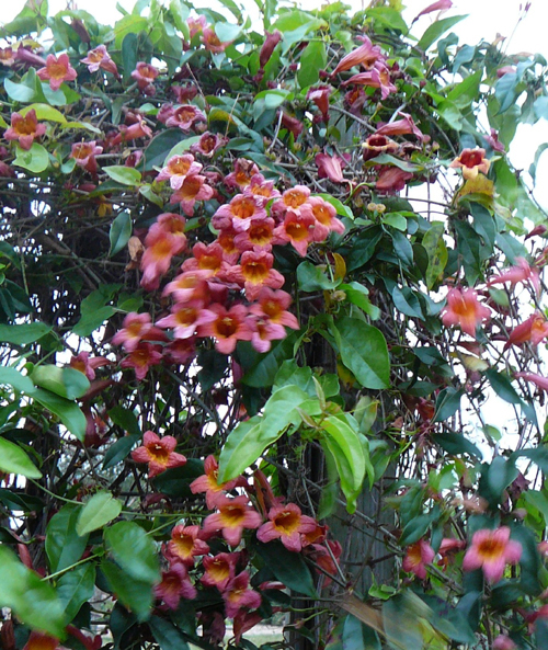
 A “Gardening for Pollinator Conservation” Workshop will take place Thursday, October 13, at the UF/IFAS North Florida Research and Education Center (NFREC) in Quincy. Pollinators are important in conserving native plants, ensuring a plentiful food supply, encouraging biodiversity and helping maintain a healthier ecological environment – – – the so-called “balance of nature.” Come learn how you can conserve and promote pollinators in your own garden, all while beautifying your own little piece of Nature.
As in previous years, nursery vendors will be selling pollinator plants at the Oct. 13 workshop, making it convenient for you to put into practice what you learn at the workshop! Registration is just $15 per person and includes lunch, refreshments, and handouts.
Check out the workshop details and register at: https://gardeningforpollinatorconservation.eventbrite.com/
What: Gardening for Pollinator Conservation
When: Thursday, October 13, 8:30 am to 5:00 pm EDT
Where: University of Florida/IFAS North Florida Research and Education Center, 155 Research Road, Quincy, FL. Located just north of I-10 Exit 181, 3 miles south of Quincy, off Pat Thomas Highway, SR 267.
Cost: $15 per person (includes lunch, refreshments and handouts)
Registration: https://gardeningforpollinatorconservation.eventbrite.com
For more information, contact: Gary Knox, gwknox@ufl.edu; 850.875.7105
For a printable Flyer click here: Gardening for Pollinators Workshop
Our workshop builds on previous successful pollinator workshops held at Leon Co. Extension last year and in Marianna in 2012. This workshop was developed as a collaboration of county faculty from several extension offices with folks from the Florida Fish & Wildlife Conservation Commission as well as UF/IFAS NFREC. Sponsors helping defray costs include Florida Native Plant Society – Magnolia Chapter, Gardening Friends of the Big Bend, Inc., Mail-Order Natives, and University of Florida/IFAS North Florida Research and Education Center.
We look forward to seeing you at the workshop!

by Rick O'Connor | Sep 30, 2016
Recently I attended a conference that included a series of talks at the University of Florida’s Whitney Marine Lab. One of the talks was presented by the director of the lab, Dr. Mark Martindale, who discussed the history and mission of the lab. However, in that talk he made a comment that caught my attention.
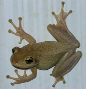
is this a Cuban Tree Frog? Do I have to rely on DNA barconding to know for sure – before I decide to euthanize it? Could I be making a mistake?
Image by Dr. Steve A Johnson 2005.
He was discussing the work of the lab and mentioned the great diversity of microscopic life that existed in the Intracoastal Waterway right out their back door. But while discussing this he also mentioned that today’s biology students identify organisms by DNA markers. Going are the days of collecting the creatures and using taxonomic keys to identify using physical characteristics of the organism. What do I mean by this? Well, the “old timers” would wonder through the woods and shorelines, collecting specimens, and observing their physical characteristics… do they have legs? How many legs do they have? How many antennae do they possess? These “old timers” would observe the natural world, develop taxonomic keys (list of characters to help identify), have them peer reviewed, published, and occasionally updated. New microscopic techniques would alert them to mistakes they may have made and thus corrections and “re-do’s” could be done. There were specialists in this field called taxonomists. If you brought in a seashell, they would be able to identify relatively quickly. If they were confused on a few characters, they would contact their colleagues and an agreement would be reached on the proper identification. And so it went.
Today, this is not needed. The sequencing of genomes of many species have been done. The barcode method of identification by the “new school” is more accurate… as long as the sequence is correct, your identification is correct. There are fewer mistakes. Now problems like identifying what is partially digested in a fish gut can actually be done accurately. In some cases, we are learning that the classic “taxonomic tree” may have some flaws. Creatures whose physical characteristics suggest they are related, may in fact not be. We are looking at the progression of life all over again – it is an exciting time for biologists in many ways. But are we losing something by letting the “old natural history” methods go?
One example I can give is identification of a small marine creature called a lancelot. I was doing a survey of marine life at a local restoration project and collected several of these. I was trained by old school biologists and remembered there were four species of these found in our area. I looked through my old college notes to see if I could find how to tell them apart. I could not find those specific notes. So I thought I would contact local biologists for assistance… no one knew… they suggested I try this… try that… I finally decided that the only one who still knew was my old vertebrate zoology professor, Dr. Herbert Boshung. Unfortunately, Dr. Boshung – like so many other of the “old school” – had passed away.
And there I was… with a creature that I could not identify. The “new school” was not able to help. Could this be happening across the country, across the world. As the “old school” move on and the “new school” move in could we be losing a part of natural history that we won’t be able to get back? This concerned me some. To have people who should know, look at something and say “I do not know what that is” was a little disconcerting. Dr. Martindale thought we may have to “re-discover” all of this knowledge within the “new school” – start again.
I am a marine science educator who is in between the two schools. I was taught and trained by the “old school” – folks like Dr, Boshung and Dr. William Cliburn. I learned a LOT about our natural world through them and have used their “old school” methods to teach my students. The “new school” method of learning about the natural world has made wonderful discoveries and it is exciting to see what corrections will be made and what lionfish are actually eating. But I still feel the loss of the “old school” natural history is a true loss. We in Extension are often asked “can you identify this creature?” Those who have been trained “old school” can – or least to genus. “New school” not so much anymore. They can, but not by looking at it. This just seems to be a part of science education we should hold on to.
There is one place where the non-scientist interested in learning some of the “old school” methods still can… the Florida Master Naturalist Program. This program consists of three modules – uplands, wetlands/freshwater, and coastal. Participants will learn about the natural history and how to identify specific groups of creatures found in these systems – the old school way. For those interested in this I think it is a great program. It is offered through most county extension offices across the panhandle. To find out more about the program, and what modules are being offered in your area, visit http://www.masternaturalist.ifas.ufl.edu/
by Rick O'Connor | Sep 23, 2016
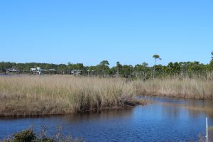
Humans have been settling on, and around, coastal estuaries since they first arrived in the panhandle over 10,000 years ago. These bodies of water have provided food and recreation as long as anyone can remember. They are a magnet for those looking to build homes or businesses – and we continue to be attracted to them today.
Black Needlerush is one of the species of marsh grasses that live in brackish conditions.
Estuaries are defined as semi-enclosed bodies of water where fresh and sea water mix. The point where the freshwater enters is called the head of the bay; the point where seawater enters is called the mouth. Seawater is denser than freshwater so during incoming tides the saline water tends to “wedge” it’s way into the upper estuary along the bottom. Under certain conditions, it is possible to catch freshwater fish near the surface and marine species on the bottom at the same location. The mixture of fresh and seawater makes for an interesting cocktail of salinities termed brackish water – which is required for the development of almost 90% of the commercially valuable seafood species we enjoy. This ecosystem supports stands of vegetation which are also important in the development of some species – some of these systems are the most biologically productive on the planet.
We are lucky to have several large estuaries along the Florida panhandle. All of our bays are what are called drowned river valleys. Most are very wide and pretty shallow, with the highest average depth being 17 feet in Choctawhatchee Bay. The rivers that feed these estuaries begin in states north of us and bring with them needed freshwater and nutrients. Each of the panhandle estuaries is unique and provides different resources for their neighboring communities. Below is a breakdown of some of these characteristics. This information was provided by GulfBase.org.
| Bay |
Surface Area (km2) |
Drainage Area (km2) |
Avg. Daily Inflow (m3/sec) |
Avg. Depth (m) |
Avg. Salinity (ppt) |
Area of Wetlands (km2) |
Area of Submerged Vegetation (km2) |
| Perdido |
130 |
3,100 |
62 |
3.0 |
15 |
688 |
ND |
| Pensacola |
370 |
18,100 |
328 |
4.0 |
23 |
991 |
32 |
| Choctawhatchee |
334 |
14,000 |
241 |
5.0 |
25 |
1,133 |
12 |
| St. Andrews |
243 |
2,800 |
127 |
4.0 |
31 |
1,016 |
53 |
| St. Joseph ND |
|
|
|
|
|
|
|
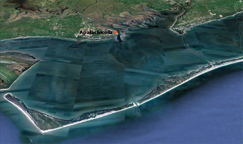
| Apalachicola |
554 |
53,100 |
824 |
3.0 |
22 |
2,396 |
36 |
| Apalachee |
412 |
11,900 |
150 |
3.0 |
30 |
2,813 |
130 |
You can see some of our estuaries have large areas and tremendous amounts of freshwater inflow. Others not so much, the bays with less freshwater inflow have higher salinities – and support a different ecology than the others. Is one better than the other?… no… certainly our ancestors understood this. Higher salinities meant more seagrass, scallops, and urchins – certain species of fish and maybe even marine turtles could be found here. Lower salinities meant a different group of fish, oysters, and crabs. It’s all good! Residents should benefit from what the bay provides – and not try to make “your bay” more like “another bay”.
They have suffered some over the years – discharge containing organic and inorganic chemicals have tainted some drinking water supplies as well as reduce valuable aquatic resources. Increased sediments from development have darkened the waters reducing light and reducing submerged plants. Heavily fishing and recreation have impacted both the habitats and the species that inhabit them. Through the efforts of universities, government agencies, non-profit organizations, and private citizens many of the problems have been addressed – and recovery is occurring… but there is still more to do.
National Estuaries Week is a chance for all who live in the panhandle to realize how important these bodies of water are to our locally economy and to our quality of life. We hope you will appreciate them and do your part to help protect them. HAPPY NATIONAL ESTUARIES WEEK!
by Rick O'Connor | Aug 12, 2016
Yea… should we? Probably your next question would be – can we?
The answer is… maybe
There was an interesting article in the June edition of the Smithsonian magazine. It discussed this question. Science is close to being able to eliminate mosquitos… sort of… there is more to it… but it brings up an interesting question – should man be allowed to eliminate a species from history? Some would say – “well, it’s not the first time we have done this… so why not?”. Others would say “this is not correct… we should not be the ones to decide which species are allowed to exist and which are not.” But there is more to the story…
There are about 3,500 species of mosquito known to science, about 100 of these are known vectors for human diseases. 725,000 human deaths are caused by mosquito borne diseases each year. The Smithsonian article quotes other wildlife induced human deaths for comparison. Between 20,000 and 200,000 die from parasites transmitted by freshwater snails, between 44,000 and 125,000 die from snake bite, between 55,000 and 60,000 from dog bites, and 6 from sharks (another testament that sharks are not the threat most people think they are), but almost three quarters of a million humans die each year to mosquito bites is significant… should we consider eliminating them?
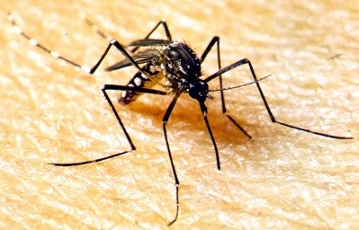
Anopheles gambiae is the mosquito that transmits malaria.
Photo: UF IFAS
Dr. Andrea Crisanti, research scientist at Imperial College in London, has spent most of his life trying to end malaria – he would like to see it eliminated. Malaria alone killed 400,000 people in sub-Sahara Africa in 2015. The protozoan that causes malaria is transmitted by the mosquito known as Anopheles gambiae. He, and other scientists, have developed independently – the different pieces of a method that may eliminate this species of mosquito. It is basically a gene therapy method. They insert a lethal gene into the DNA of the mosquito, release it into the environment, mating ensues, death occurs, species is illuminated.
Now comes the maybe part…
This type of technology has been used to develop a variety of corn that produces its own pesticide. However, the pollination part is done within a controlled lab and the plants are planted in the fields. This would require successful breeding within the environment… it might work. The other issue is that this method is species specific. Would another species adapt and begin to transmit the malaria protozoan? And, of course, there is the question of unforeseen consequences. Because mosquitos do not travel far from where they were born, most researchers do not think this method would eliminate a species on a global scale – but rather on a local one. Scientists have been able to sterilize mosquitos using gamma radiation. Reducing an entire population has had mixed results. They are currently working on a non-radiation method for the Asian Tiger Mosquito (Aedes albopictus), one of the local vectors for Zika.
Researchers are currently targeting three species of mosquito for this project. Anopheles gambiae (the carrier of malaria), Aedes aegyptie (the carrier of yellow fever, and possibly Zika), and Culex (which carries west nile and others). But the questions still lie out there – (1) will it work?, (2) are there other consequences?, (3) is eliminating a species ethical?
There are many scientists who think it is okay. Dr. E.O. Wilson stated Anopheles gambiae can go. Many others are concerned about upsetting the ecology of a system by removing a food source. Ecologists state that it could impact the balance of the tundra ecosystem, where mosquitos are a major food source for many of the local birds. But in other locations, the mosquito predators will find other species of mosquitos (or other food in general), and that this would not impact the system. Other scientists say no… we should not. One mentioned he did not want to be part of eliminating a species from the planet, it is not our role. Others are concerned with which species would be next? Where will this stop? And there is always the chance that biological weapons can be developed with this technology.
It is an interesting question.
by Rick O'Connor | Jul 27, 2016
Many consider Northwest Florida as the “Canoe Capitol” of the state. We have numerous rivers, creeks, and springs that are great paddling spots. The scenery is great, wildlife is common, and most are easily accessed.
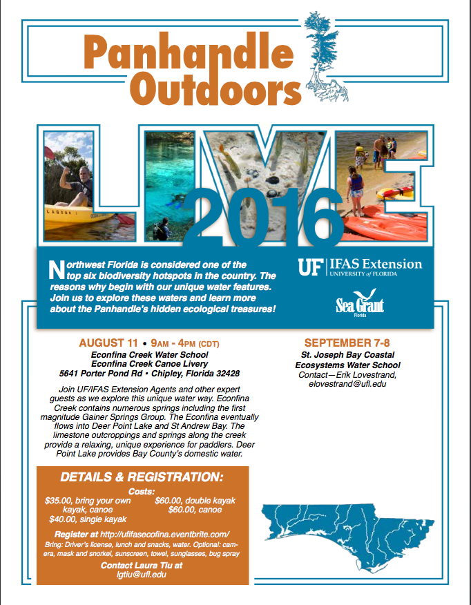
To introduce residents and visitors to the natural history of these waterways, UF/IFAS Extension Agents, and other experts, will lead a paddle trip down one of the many paddling creeks in our area – the Econfina Creek. This creek is one of the more unique ones. The term Econfina is a Muskogean (Creek) term meaning “land bridge” – which apparently existed near the present sight of Highway 20. However, the land bridge is no longer there. This creek runs 22 miles but the upper section is very difficult to paddle. Shallow, fast moving water winds its way through limestone gorges as the land drops at a rate of 7.9 feet / mile (one of the steepest in the state). The lower 6 miles (where our trip takes place) slows, meandering past several springs – including the first magnitude Ganier Springs – limestone outcrops, and lush vegetation – some plant species originate from the Appalachians. There is the chance of seeing some local wildlife including river otters. This lower section is slower and more relaxing and the scenery was graded an “A” by several canoeing guides.
The participants in the program will not only learn about the local natural history of this panhandle waterway but about some of the issues these unique habitats are currently facing. Field experts with the Northwest Florida Water Management District, Florida Fish and Wildlife Commission, and others will share insight to how we can protect these treasured ecosystems. To learn more about the trip contact Dr. Laura Tiu (lgtiu@ufl.edu) or to register visit http://ufifasecofina.eventbrite.com/ .
by Rick O'Connor | Jul 27, 2016
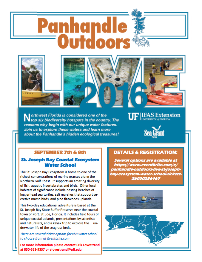
Who does not like St. Joseph Bay! What a place… One of the more pristine estuaries in Florida, St. Joe is famous for its snorkeling, fishing, kayaking, and scalloping.
15 miles long and 6 miles across (at its widest point), St. Joe Bay has no significant freshwater input. It’s only opening is to the north and into the Gulf of Mexico. Because of the high salinity in the bay the seagrasses flourish. There are five known species that exist here and the meadows cover almost one sixth of the bottom. Healthy grasses mean diverse wildlife – and St. Joe Bay has it. Migratory birds, octopus, sea turtles, sport fish, urchins, and of course scallops.
The UF/IFAS Extension Natural Resource Agents will be hosting one of their water school programs in St. Joe Bay in September. This two-day program will offer presentations by specialists on a variety of topics, hikes through the uplands, visits to the salt marsh, and a kayak/snorkel trip into the seagrasses themselves. We will be staying at the St. Joseph Bay State Buffer Preserve in Port St. Joe. For more information about this program contact Erik Lovestrand at (850) 653-9337 or elovestrand@ufl.edu.

