by Andrea Albertin | May 4, 2018
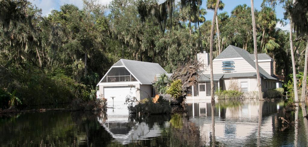
Special care needs to be taken with a septic system after a flood or heavy rains. Photo credit: Flooding in Deltona, FL after Hurricane Irma. P. Lynch/FEMA
Approximately 30% of Florida’s population relies on septic systems, or onsite sewage treatment and disposal systems (OSTDS), to treat and dispose of household wastewater. This includes all water from bathrooms and kitchens, and laundry machines.
When properly maintained, septic systems can last 25-30 years, and maintenance costs are relatively low. In a nutshell, the most important things you can do to maintain your system is to make sure nothing but toilet paper is flushed down toilets, reduce the amount of oils and fats that go down your kitchen sink, and have the system pumped every 3-5 years, depending on the size of your tank and number of people in your household.
During floods or heavy rains, the soil around the septic tank and in the drain field become saturated, or water-logged, and the effluent from the septic tank can’t properly drain though the soil. Special care needs to be taken with your septic system during and after a flood or heavy rains.
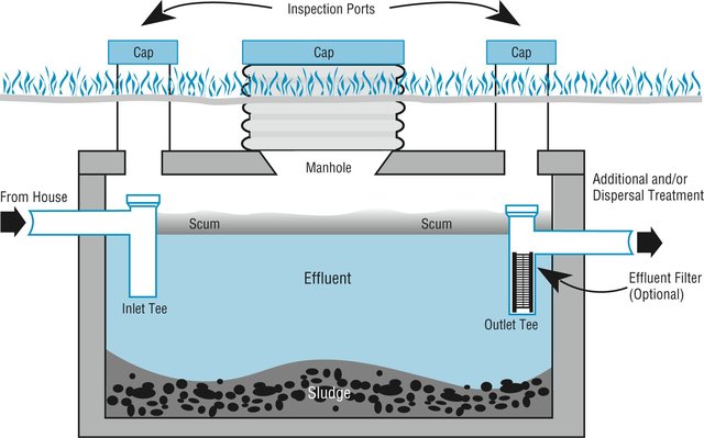
Image credit: wfeiden CC by SA 2.0
How does a traditional septic system work?
The most common type of OSTDS is a conventional septic system, made up of (1) a septic tank (above), which is a watertight container buried in the ground and (2) a drain field, or leach field. The effluent (liquid wastewater) from the tank flows into the drain field, which is usually a series of buried perforated pipes. The septic tank’s job is to separate out solids (which settle on the bottom as sludge), from oils and grease, which float to the top and form a scum layer. Bacteria break down the solids (the organic matter) in the tank. The effluent, which is in the middle layer of the tank, flows out of the tank and into the drain field where it then percolates down through the ground.
During floods or heavy rains, the soil around the septic tank and in the drain field become saturated, or water-logged, and the effluent from the septic tank can’t properly drain though the soil. Special care needs to be taken with your septic system during and after a flood or heavy rains.
What should you do after flooding occurs?
- Relieve pressure on the septic system by using it less or not at all until floodwaters recede and the soil has drained. For your septic system to work properly, water needs to drain freely in the drain field. Under flooded conditions, water can’t drain properly and can back up in your system. Remember that in most homes all water sent down the pipes goes into the septic system. Clean up floodwater in the house without dumping it into the sinks or toilet.
- Avoid digging around the septic tank and drain field while the soil is water logged. Don’t drive heavy vehicles or equipment over the drain field. By using heavy equipment or working under water-logged conditions, you can compact the soil in your drain field, and water won’t be able to drain properly.
- Don’t open or pump out the septic tank if the soil is still saturated. Silt and mud can get into the tank if it is opened, and can end up in the drain field, reducing its drainage capability. Pumping under these conditions can also cause a tank to pop out of the ground.
- If you suspect your system has been damage, have the tank inspected and serviced by a professional. How can you tell if your system is damaged? Signs include: settling, wastewater backs up into household drains, the soil in the drain field remains soggy and never fully drains, and/or a foul odor persists around the tank and drain field.
- Keep rainwater drainage systems away from the septic drain field. As a preventive measure, make sure that water from roof gutters doesn’t drain into your septic drain field – this adds an additional source of water that the drain field has to manage.
More information on septic system maintenance after flooding can be found on the EPA website publication https://www.epa.gov/ground-water-and-drinking-water/septic-systems-what-do-after-flood
By taking special care with your septic system after flooding, you can contribute to the health of your household, community and environment.
by Laura Tiu | Apr 14, 2018
Spring has sprung and it is time to get outside and explore this great Florida Panhandle area. In neighboring Santa Rosa County, a terrific destination for a variety of outdoor activities is Blackwater River State Park. Visitors can canoe, kayak, tube, fish and swim the river. Hikers can enjoy trails through nearly 600 acres of undisturbed natural communities. Bring a picnic and hang out at one of several pavilions or white sand beaches that dot the river (restroom facilities available). Near the pavilions, stop and see one of the largest and oldest Atlantic white cedars, recognized as a Florida Champion tree in 1982. The park also offers 30 campsites for tents and RVs. Park entry is $4.00 per car, payable at the ranger station or via the honor system (bring exact change, please).
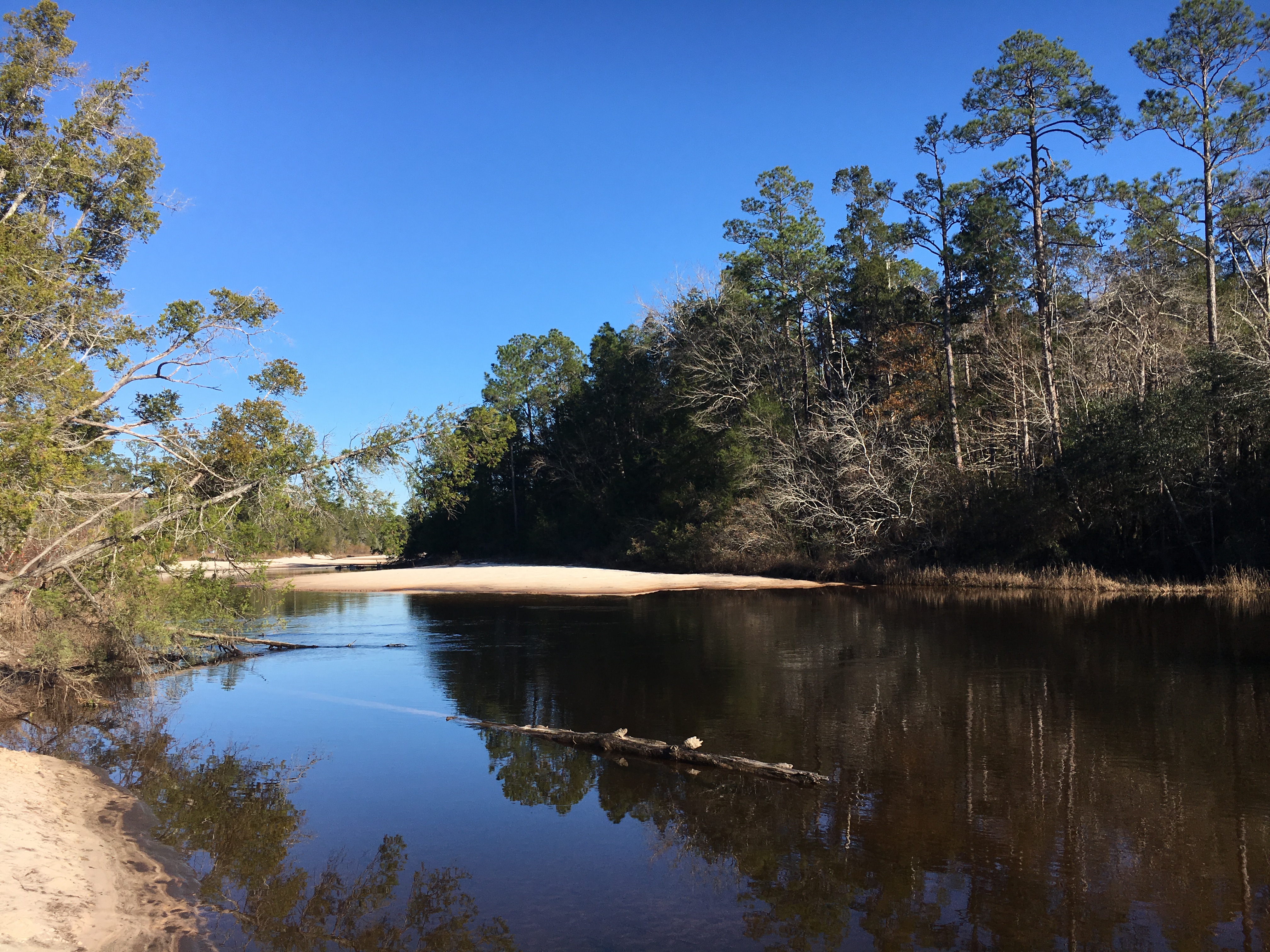
The Blackwater River is considered one of the purest and pristine sand-bottom rivers in the world. The water is tea-colored from the tannins and organic matter that color the water as it weaves through the predominantly pine forest. The river is shallow with a beautiful white sandy bottom, a nice feature for those tubing or paddling the trail. The river flows for over 50 miles and is designated as a Florida canoe trail. Multiple small sand beach areas line the river and provide plenty of space to hang out, picnic, or throw a Frisbee. Blackwater eventually flows into Pensacola Bay and the Gulf of Mexico bringing high quality freshwater into this important estuary.
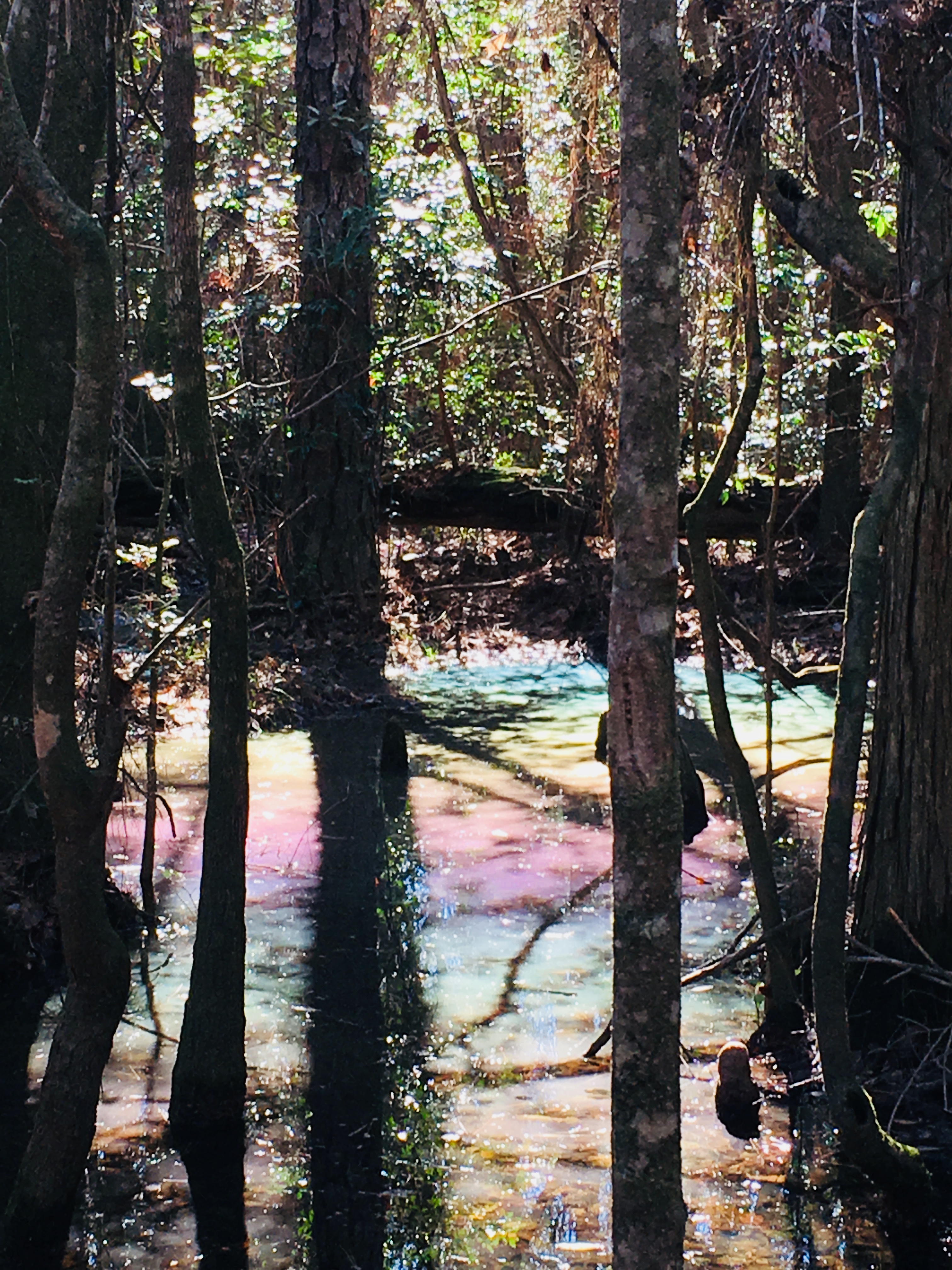
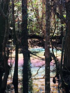
A favorite trail in the Park is the Chain of Lakes Nature Trail. Parking for this 1.75 mile loop trail is at South Bridge on Deaton Bridge Road. The trail head is well marked and has a boardwalk that leads into the floodplain forest. The trail winds through a chain of shallow oxbow lakes and swamp that dot the former route of the river. If you are lucky and it is a clear, blue-sky day, you may see a beautiful rainbow effect as the sun hits the water. We call this the pastel swamp rainbow effect. This is a result of the natural oils from the cypress cones settling on the surface of the water and associated trapped pollen.
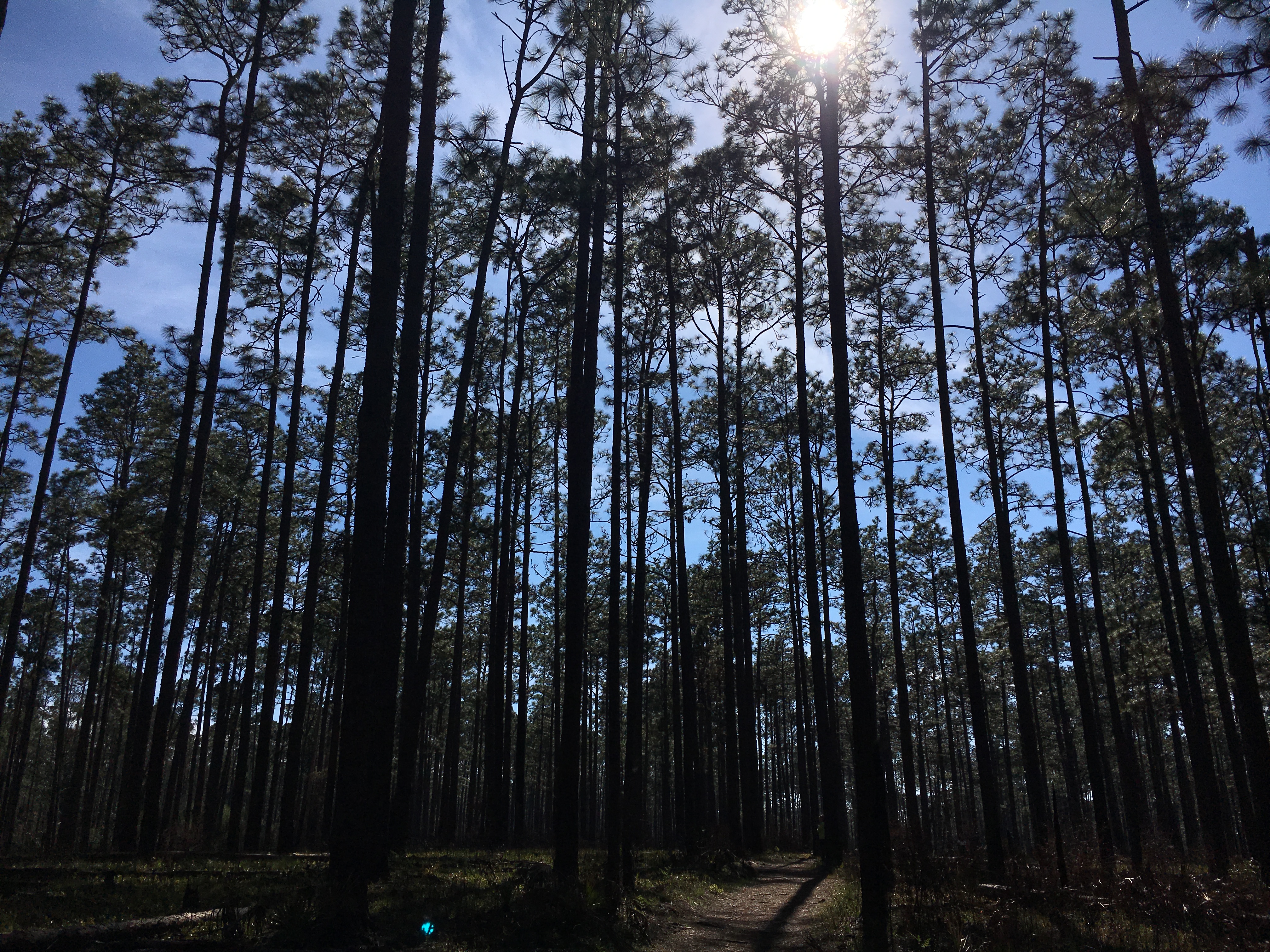
The trail then turns to sneak through the sandhill community in the park with giant longleaf pines, wiregrass and turkey oak. Evidence of prescribed burning shows management efforts to maintain the forest. Cinnamon ferns, bamboo and other natives appear in pockets along the trail. The trail in this section is blanketed with a mosaic of exposed root systems, so be careful as you step. Finally, pack some bug spray and a water bottle for this fun hike.
For more information, visit the park page: https://www.floridastateparks.org/park/Blackwater-River
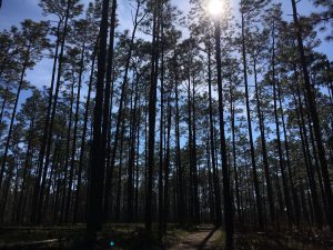
Sandhill pine forest at Blackwater River State Park
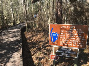
2737 – Chain of Lakes trailhead at Blackwater River State Park
“Rainbow Swamp” on the Chain of Lakes trail at Blackwater River State Park
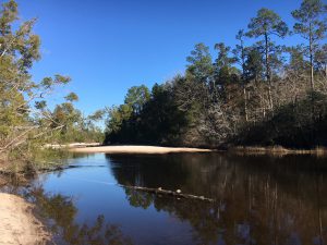
Beautiful sandy beaches along the Blackwater River in the State Park.
by Sheila Dunning | Apr 14, 2018
Having just completed the Okaloosa/Walton Uplands Master Naturalist course, I would like to share information from the project that was presented by Ann Foley.
The Florida Torreya. Photo provided by Shelia Dunning
The Florida Torreya is the most endangered tree in North America, and perhaps the world! Less than 1% of the historical population survives. Unless something is done soon, it may disappear entirely! You can see them on public lands in Florida at Apalachicola Bluffs and Ravines Preserve and beautiful Torreya State Park.
The Florida Torreya (Torreya taxifolia) is one of the oldest known tree species on earth; 160 million years old. It was originally an Appalachian Mountains ranged tree. As a result of our last “Ice Age” melt, retreating Icebergs pushed ground from the Northern Hemisphere, bringing the Florida Torreya and many other northern plant species with them.
The Florida Torreya was “left behind” in its current native pocket refuge, a short 40 mile stretch along the banks of the Apalachicola River. There were estimates of 600,000 to 1,000,000 of these trees in the 1800’s. Torreya State Park, named for this special tree, is currently home to about 600 of them. Barely thriving, this tree prefers a shady habitat with dark, moist, sandy loam of limestone origin which the park has to offer.
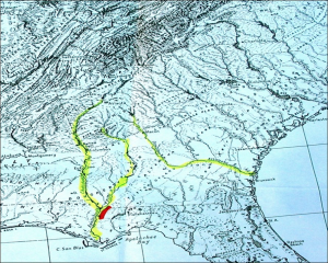
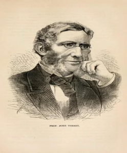
Hardy Bryan Croom, Botanist, discovered the tree in 1833, along the bluffs and ravines of Jackson, Liberty and Gadsen Counties, Florida and Decatur County in Georgia. He named it Florida Torreya (TOR-ee-uh), in honor of Dr. John Torrey, a renowned 18th century scientist.
Torreya trees are evergreen conifers, conically shaped, have whorled branches and stiff, sharp pointed, dark green needle-like leaves. Scientists noted the Torreya’s decline as far back as the 1950’s! Mature tree heights were once noted at 60 feet, but today’s trees are immature specimens of 3-6 feet, thought to be ‘root/stump sprouts.’
Known locally as “Stinking Cedar,” due to its strong smell when the leaves and cones are crushed, it was used for fence posts, cabinets, roof shingles, Christmas trees and riverboat fuel. Over-harvesting in the past and natural processes are taking a tremendous toll. Fungi are attacking weakened trees, causing the critically endangered species to die-off. Other declining factors include: drought, habitat loss, deer and loss of reproductive capability.
With federal and state protection, the Florida Torreya was listed as an endangered species in 1983. There is great concern for this ancient tree in scientific community and with citizen organizations. Efforts are underway to help bring this tree back from the edge of extinction!
Efforts include CRISPR gene editing technology research being done by the University of Florida Dept. of Forest Resources and Conservation- making the tree more resistant to disease. Torreya Guardians “rewilding and “assisted migration”. Reintroducing the tree to it’s former native range in the north near the Biltmore Estate in Asheville, NC, which has maintained a grove of Torreya trees and offspring since 1939 and supplying seeds for propagation from their healthy forest. Long before saving the earth became a global concern, Dr. Seuss (Theodor Seuss Geisel), spoke through his character the Lorax warning against urban progress and the danger it posed to the earth’s natural beauty. All of these groups, and many others, hope their efforts will collectively help bring this tree back from the brink!
by Erik Lovestrand | Feb 2, 2018
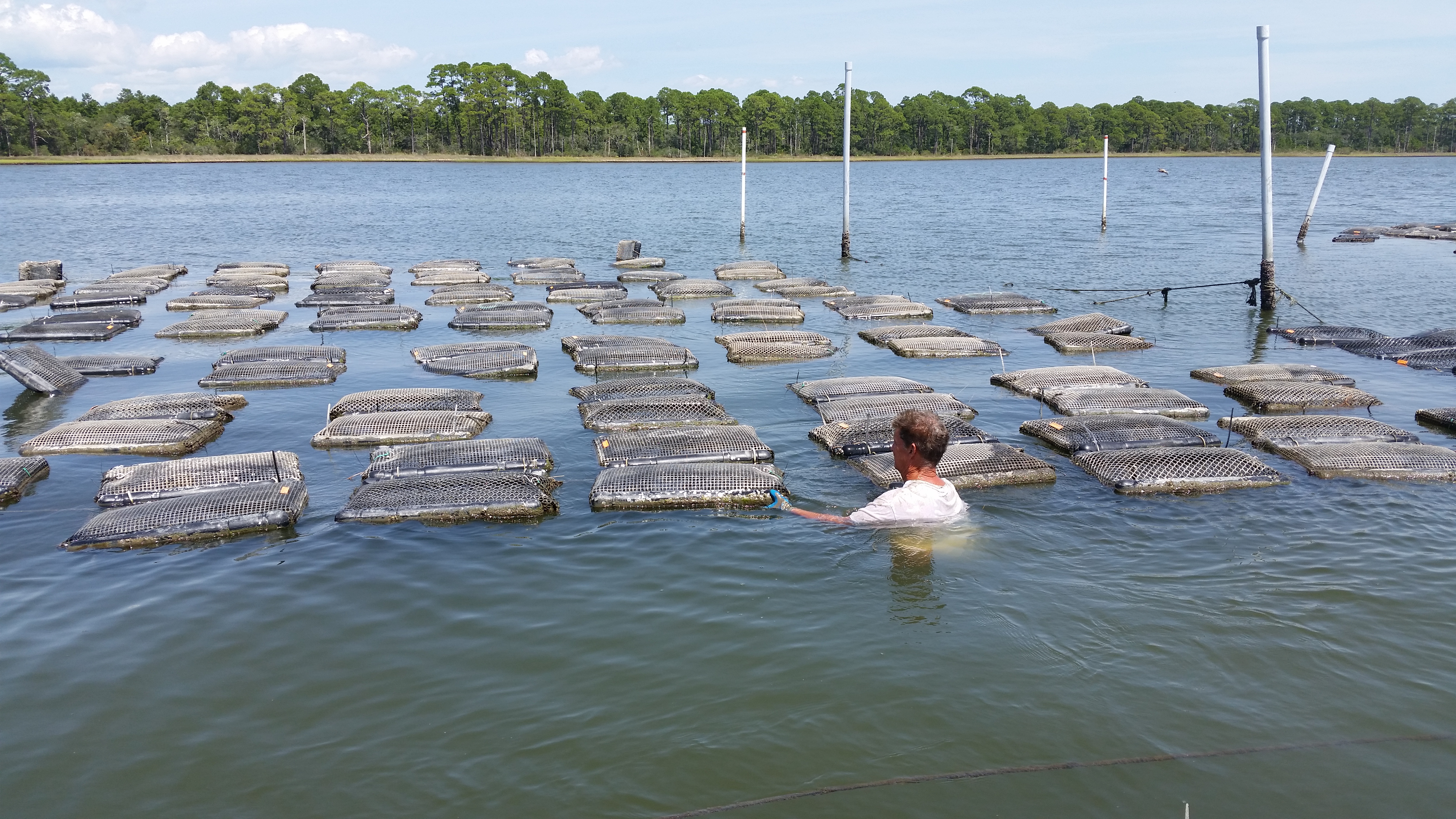
Sorting and re-caging take place on-site at the lease
Photo: Erik Lovestrand
There are a number of parallels than can be drawn between shellfish farming and traditional forms of agriculture that take place on the land. The most obvious similarities are the amount of hard work, grit and faith that are required of the farmer on land or sea. In spite of this there are many “salty” farmers in the Florida Panhandle who have mustered the faith requirement and are now putting in the hard work necessary to help build this budding industry in the Southeastern U.S.
Market demand for quality oysters has continued to outstrip available supplies for several years of late. This has been due in part to better marketing strategies employed by growers as well as clientele becoming aware of the health benefits of fresh oysters; a great supply of important vitamins and minerals, including vitamin C and B vitamins, zinc, selenium and iron. However, supply/demand ratios are not the only important factor in developing a thriving oyster aquaculture industry. Also required, is the necessary infrastructure to support the grower’s equipment needs, enough sources of baby oyster “seed”, a reliable refrigerated transportation network for live shellfish, and the support of regulatory agencies in making water leases available in suitable growing areas.
Fortunately, the stars seem to be aligning for many of these industry-growth necessities and the business of oyster farming is gaining a firmer foundation to build upon. One of the important milestones for Florida was the approval of “full-water-column” leases, which allows the use of floating oyster cages or bags. Previously, oysters were required to be grown on the bay bottom and this made them susceptible to higher levels of predation from crabs and snails and severe biofouling (barnacles and algae) on the exterior of the mesh bags. Heavy biofouling reduces the water flow through the oyster’s growing environment, thus the available food for this filter feeding bivalve.
One critical need for this industry is the availability of quality “seed” (baby oysters) to put in the growing waters. Seed oysters are supplied by hatcheries where oyster brood stocks are spawned and babies are raised to the necessary age for grower needs. Some growers use baby oyster larvae that have not settled and attached yet. These “eyed larvae” are put in a tank with old oyster shell and allowed to attach on the shells, which are then deployed at a lease site. Other growers use seed that has already attached to a small particle of crushed shell and are sold as individual oysters to be placed in grow-out bags or cages. The more recent development of oyster stocks with 3 sets of chromosomes (triploids) have provided growers with an oyster that gets to market size faster. Triploid oysters are infertile and do not use energy for spawning, thereby putting more energy into shell and tissue growth. Federal and state laws also govern where growers can buy their seed in an effort aimed at stopping the spread of shellfish disease from one body of water to another (i.e. Atlantic to Gulf of Mexico, etc.).
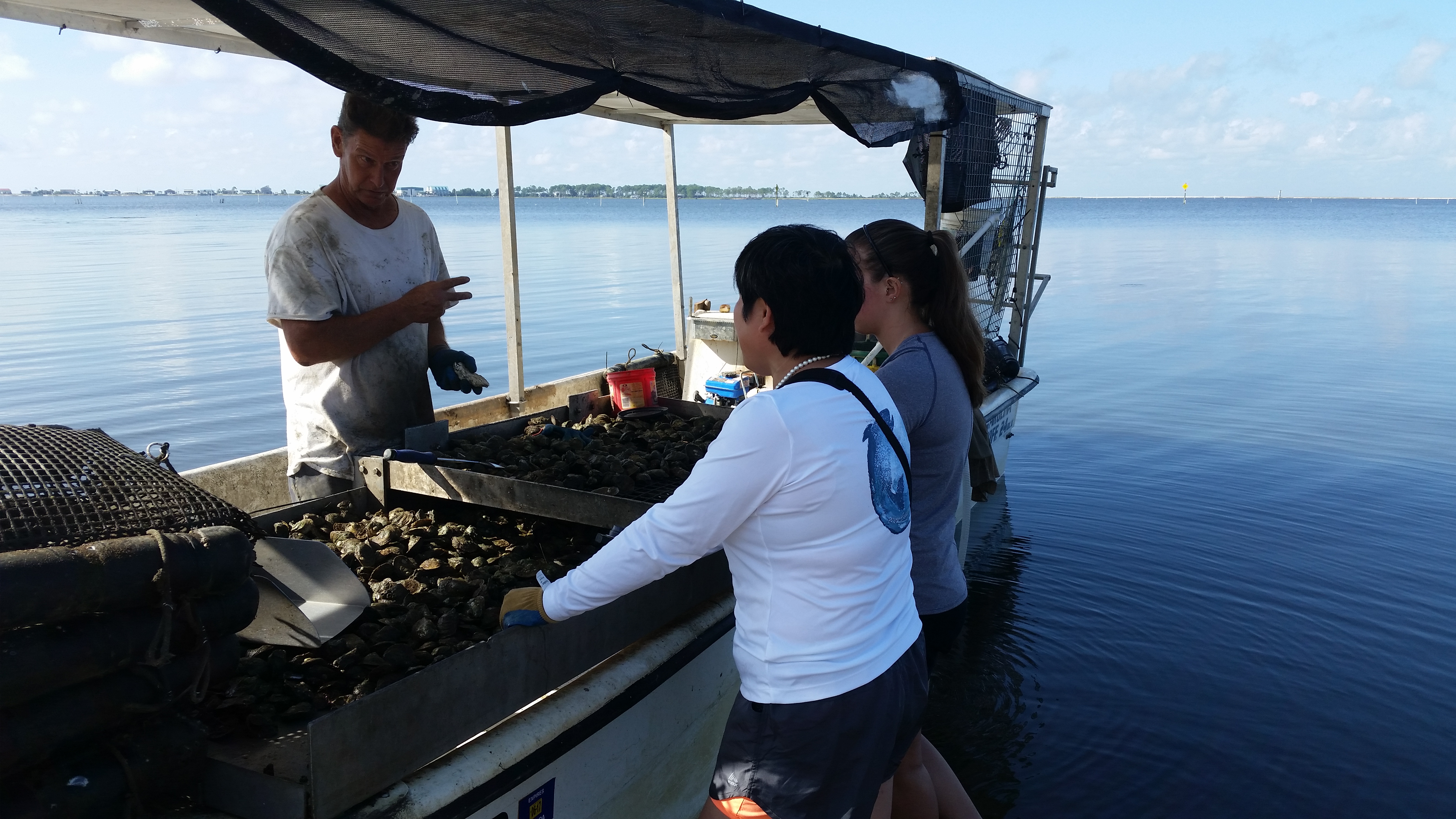
Even if all of the hardware and infrastructure is in place, there is still one other factor that plays a significant role in whether an oyster farmer will be successful. Just like the dairy farmer, the cattle rancher, the cotton or peanut grower, or the blueberry producer; backbreaking labor is necessary for many stages of the production cycle. Oyster growers work their leases either bending over the gunnels of a boat or actually being in the water, lifting heavy bags or cages of shellfish, sorting by size, re-caging, and moving lots of materials to and from the lease area. True grit and a dogged determination to stay on top of things, regardless of unpleasant conditions, are vital to raising a successful crop of oysters. And by the way, don’t forget that Mother Nature will have the final word. As all farmers know, they are required to be a good listener when she speaks.

by Sheila Dunning | Jan 19, 2018
The Florida Master Naturalist Program is an adult education University of Florida/IFAS Extension program. Training will benefit persons interested in learning more about Florida’s environment or wishing to increase their knowledge for use in education programs as volunteers, employees, ecotourism guides, and others.
Through classroom, field trip, and practical experience, each module provides instruction on the general ecology, habitats, vegetation types, wildlife, and conservation issues of Coastal, Freshwater and Upland systems. Additional special topics focus on Conservation Science, Environmental Interpretation, Habitat Evaluation, Wildlife Monitoring and Coastal Restoration. For more information go to: http://www.masternaturalist.ifas.ufl.edu/ Okaloosa and Walton Counties will be offering Upland Systems on Thursdays from February 15- March 22. Topics discussed include Hardwood Forests, Pinelands, Scrub, Dry Prairie, Rangelands and Urban Green Spaces. The program also addresses society’s role in uplands, develops naturalist interpretation skills, and discusses environmental ethics. Check the website for a Course Offering near you :http://conference.ifas.ufl.edu/fmnp/
by Sheila Dunning | Dec 15, 2017
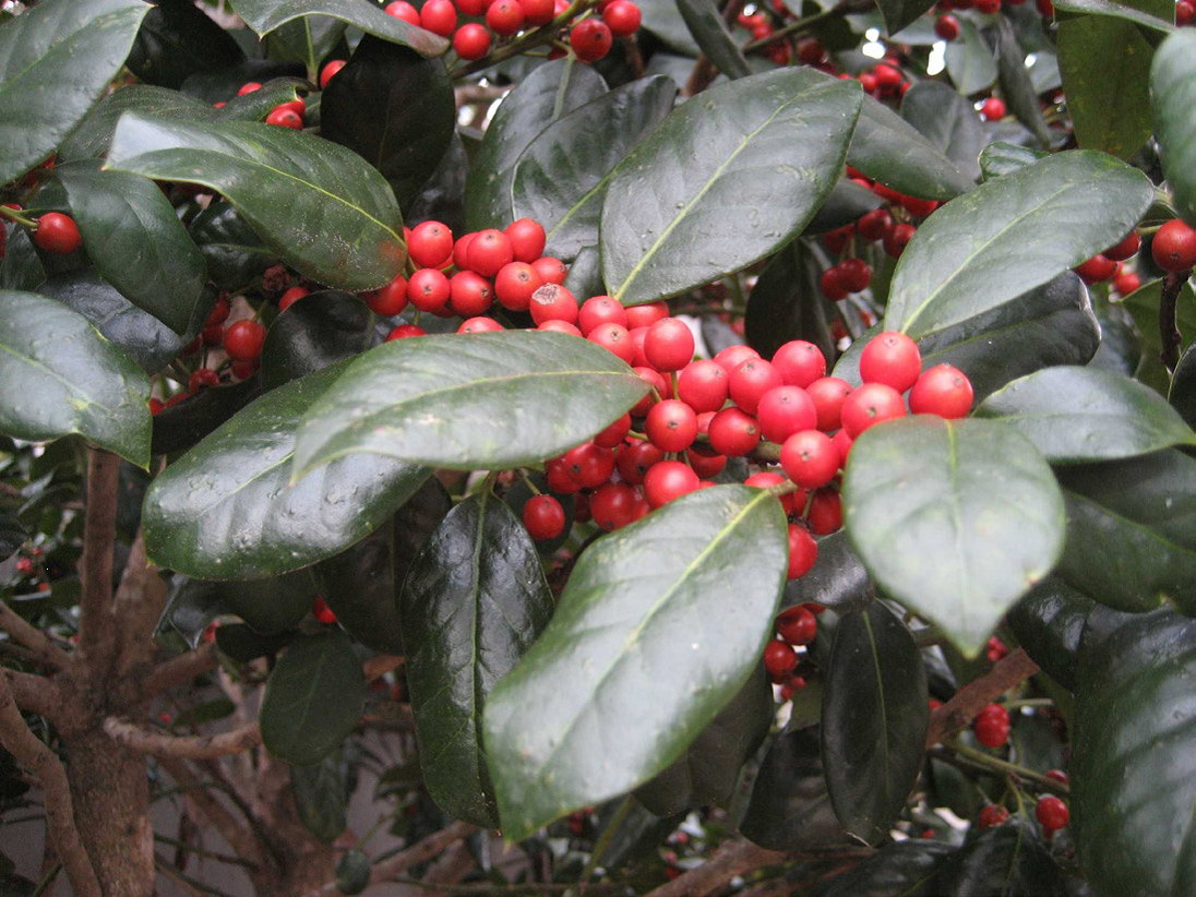
According to Druid lore, hanging the plant in homes would bring good luck and protection. Holly was considered sacred because it remained green and strong with brightly colored red berries no matter how harsh the winter. Most other plants would wilt and die.
 Later, Christians adopted the holly tradition from Druid practices and developed symbolism to reflect Christian beliefs. Today, the red berries are said to represent the blood that Jesus shed on the cross when he was crucified. Additionally, the pointed leaves of the holly symbolize the crown of thorns Jesus wore on his head.
Several hollies are native to Florida. Many more are cultivated varieties commonly used as landscape plants. Hollies (Ilex spp.) are generally low maintenance plants that come in a diversity of sizes, forms and textures, ranging from large trees to dwarf shrubs.
The berries provide a valuable winter food source for migratory birds. However, the berries only form on female plants. Hollies are dioecious plants, meaning male and female flowers are located on separate plants. Both male and female hollies produce small white blooms in the spring. Bees are the primary pollinators, carrying pollen from the male hollies 1.5 to 2 miles, so it is not necessary to have a male plant in the same landscape.
Several male hollies are grown for their compact formal shape and interesting new foliage color. Dwarf Yaupon Hollies (Ilex vomitoria ‘Shillings’ and ‘Bordeaux’) form symmetrical spheres without extensive pruning. ‘Bordeaux’ Yaupon has maroon-colored new growth. Neither cultivar has berries.
Hollies prefer to grow in partial shade but will do well in full sun if provided adequate irrigation. Most species prefer well-drained, slightly acidic soils. However, Dahoon holly (Ilex cassine) and Gallberry (Ilex glabra) naturally occurs in wetland areas and can be planted on wetter sites.
Evergreen trees retain leaves throughout the year and provide wind protection. The choice of one type of holly or another will largely depend on prevailing environmental conditions and windbreak purposes. If, for example, winds associated with storms or natural climatic variability occur in winter, then a larger leaved plant might be required.
The natives are likely to be better adapted to local climate, soil, pest and disease conditions and over a broader range of conditions. Nevertheless, non-natives may be desirable for many attributes such as height, growth rate and texture but should not reproduce and spread beyond the area planted or they may become problematic because of invasiveness.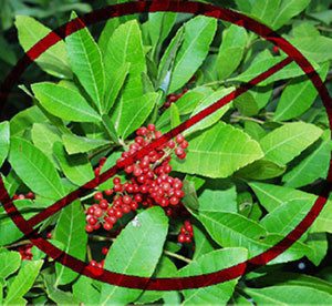
There is increasing awareness of invasiveness, i.e., the potential for an introduced species to establish itself or become “naturalized” in an ecological community and even become a dominant plant that replaces native species. Tree and shrub species can become invasive if they aggressively proliferate beyond the windbreak. At first glance, Brazilian pepper (Schinus terebinthifolius), a fast-growing, non-native shrub that has a dense crown, might be considered an appropriate red berry producing species. However, it readily spreads seed disbursed by birds and has invaded many natural ecosystems. Therefore, the Florida Department of Environmental Protection has declared it illegal to plant this tree in Florida without a special permit. Consult the Florida Exotic Pest Plant Council’s Web page (www.fleppc.org) for a list of prohibited species in Florida.
For a more comprehensive list of holly varieties and their individual growth habits refer to ENH42 Hollies at a Glance: http://edis.ifas.ufl.edu/mg021