by Rick O'Connor | Oct 6, 2017
Imagine this…
You are a sailor on a 16th century Spanish galleon anchored in a Florida Bay south of Tampa. You, along with others, are ordered to go ashore for a scouting trip to set up a base camp. You transfer over to a small skiff and row ashore to find a forest of root tangled mangroves. There is no dry beach to land so you disembark at the edge of the trees in knee-deep water. The bottom is sandy and your footing is good but you must literally crawl through the tangled mess of mangrove prop roots to finding dry ground. As you do, you encounter spider webs, numerous biting insects, and the bottom becomes muddy and footing is less stable. I am sure I would have returned to the ship to report to the captain that there is nothing of value here – let’s go back to Spain!
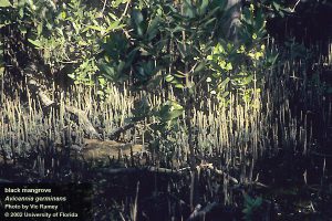
The dense vegetation of a black mangrove swamp in south Florida.
Photo: UF IFAS
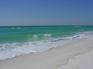
Along the shores of northwest Florida it would have been different only that they would have encountered acres of grass instead of trees. The approach to Pensacola would have found a long beach of white sand and dunes. Entering the bay, they would have found salt marshes growing in the protected areas, with the rare exception of dryer bluffs in some spots – which is where de Luna chose to anchor. These marshes are easier to traverse than the emergent root system of the mangrove, but the muck and mire of the muddy bottom and biting insects still remain.
For centuries, Europeans have sought to alter these habitats to make them more suitable for colonization. Whether that was for log forts and houses or marinas and golf courses, we have cleared the vegetation and filled the muck with fill dirt. But have we lost something by doing this?
Yes… Yes we have, and some of what we have lost is valuable to us.
We have lost our water quality.
These emergent shoreline plants filter debris running from shore to the sea during rain events. The muck and mire we encounter within the marsh would otherwise entered the bay or bayou. Here it would cloud the water and smother the submerge seagrasses. My father-in-law told me that as a kid growing up on Bayou Texar in Pensacola he remembered clear water and seagrasses. He remembered throwing a cast net and collecting 4-5″ shrimp.
That has changed.
In our modern world, it is not just mud that is running off towards our bays. We can add lawn fertilizers, lawn and garden pesticides, oils and grease from cleaning, and a multitude of other products – including plastics.
We have seen a decline in living resources.
The large shrimp my father-in-law talked about are not as common. He spoke of snapper – very few now. Bay scallops are basically gone in Pensacola and have declined across much of Florida’s gulf coast. Horseshoe crabs have become rare in many locations. Moreover, salt marsh/mangrove dependent species, such as diamondback terrapins, are difficult to find.
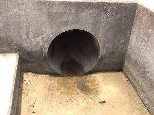
Storm drains, such as this one, discharge run-off into local bays and bayous.
Photo: Rick O’Connor
Maybe of more concern is the decline of commercially important aquatic species such as crabs, shrimp, and finfish. It is known that 80-90% of these commercially important species spend at least part of their lives in the marshes and mangroves.
And this we are losing.
And then there is the shoreline itself.
The emergent plants the Spanish encountered actually act as a wave break. Sand running off the land is trapped to form a “beach”, albeit a mucky one, and the wave energy is absorbed by the plants reducing the energy reaching the shore. The damage in south Florida from hurricane Andrew was devastating. But that same storm made a second landfall in the marshes of Louisiana and there was little to write about – the marsh absorbed much of the energy. The removal of these vegetated shorelines has enhanced the loss of coastline across the Gulf States.
Can we restore these shores and return these “services”?
Yes…
Whether communities want to or not is another question, but we can.
Studies have shown that a marsh 10′ across from water to land can remove 90% of the nutrients running off. Nutrients can trigger hypereutrophic conditions in the bay – which can lead to algal blooms – which can lead to low dissolved oxygen – which can lead to fish kills and seagrass loss. In addition to removing nutrients, marshes and mangroves can remove a variety of other contaminants and plastics. Many sewage treatment facilities discharge their treated effluent through the coastal plant communities before it reaches the bay, thus improving water quality.
We know that restoring a living shoreline will enhance the biological productivity of the bay. Studies have shown that swamps and marshes can produce an annual mean net primary production of between 8000 – 9000 kcal/m2/year, which is equivalent to tropical rainforest and the open estuary itself.
Finally, living shorelines will stabilize erosion issues, much longer than seawalls and other harden structures. Studies have shown that seawalls will eventually give in. Wave energy is increased when it meets the wall and reflects back. This generates higher energy waves that decrease seagrasses and actually begins to remove sediment around the wall itself. You will see the land begin to erode behind the wall and eventually it begins to fall forward into the bay. The east coast of Florida recently experienced this during hurricane Irma. Interestingly the west coast experienced negative tides. The exposure of these seawalls to an empty bay had the same effect. Without the water pressure to hold them, they began to crack and fall forward. A living shoreline can sustain all of this.
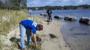
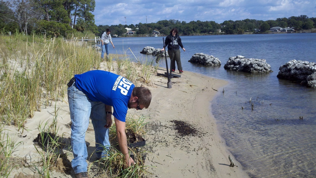
FDEP planting a living shoreline on Bayou Texar in Pensacola.
Photo: FDEP
So how do restore my shoreline?
- You will need a permit. The state of Florida owns land from the mean high tide seaward. To plant above this line you do not need a permit, but you will want to plant at and below to truly restore and benefit from the services. Permitting can be simple or complicated – each property is different. Visit http://escambia.ifas.ufl.edu/permitting-living-shorelines/ to learn more about the process.
- You will need plants. There are a few nurseries that provide the needed species. There is a zonation to the plant community and it is important to put the right plant in the right place. The above link can help with this and the Extension office is happy to visit your location and give recommendations.
- You will need to plant them. Fall and spring are good planting times. A recent project we helped with planted in April and it has been very successful.
- You may want to monitor the success of your project. This not needed, but if interested the Extension office we can show how to do this.I certainly understand why many would rather remove these shoreline ecosystems, but I think you can see the benefits outweigh the problems. It is not an all or none deal. Living shorelines can be designed to allow water access. If interested in learning more contact your county Extension office.
I certainly understand why many would rather remove these shoreline ecosystems, but I think you can see the benefits outweigh the problems. It is not an all or none deal. Living shorelines can be designed to allow water access. If interested in learning more contact your county Extension office.
References
Permitting a Living Shoreline; can a living shoreline work for you? http://escambia.ifas.ufl.edu/permitting-living-shorelines/.
Miller Jr., G.T., S.E. Spoolman. 2011. Living in the Environment: Concepts, Connections, and Solutions. 16th edition. Brooks and Cole Cengage Learning. Pp. 674.
Sharma, S. J. Goff, J. Cebrian, C. Ferraro. 2016. A Hybrid Shoreline Stabilization Technique: Impact of Modified Intertidal Reefs on Marsh Expansion and Nekton Habitat in the Northern Gulf of Mexico. Ecological Engineering 90. Pp 352-360.
by Judy Biss | Sep 22, 2017
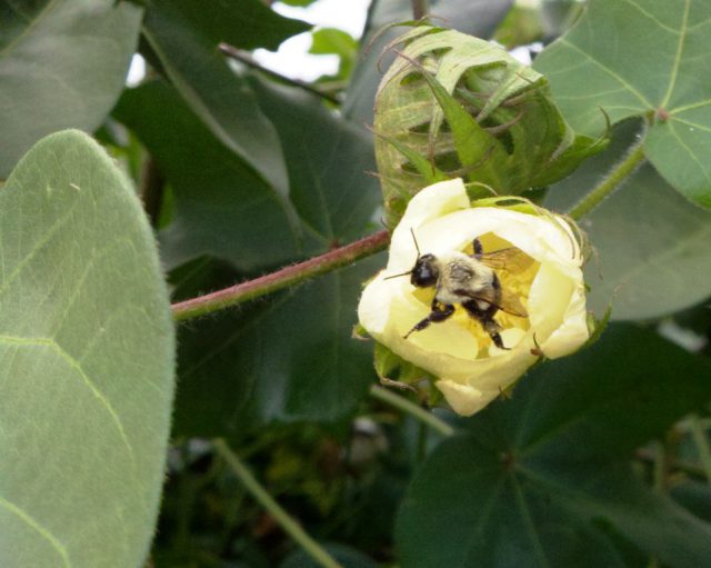
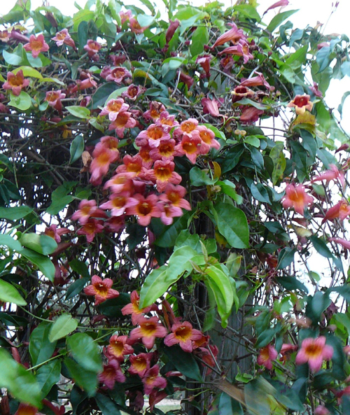
Cotton is largely self-pollinating but attractive to bees. Pollination by bees can increase seed set per boll. Photo by Judy Biss
“The happiness of the bee and the dolphin is to exist.
For man it is to know that and to wonder at it.”
Jacques Yves Cousteau
Bumble bees are among the most recognizable types of insects. They are large, colorful, and a wonder to watch. They’re also popularized in media, cartoons, and clip-art images, but beyond the popular images, bumble bees are worthy of our attention as important pollinators of both native plants and agricultural crops. They are one of hundreds of pollinating bees that are critical to the abundance of our native lands, wildlife, and also our food supply. Protection of pollinators has received national recognition and many programs are now geared towards pollinator conservation.
Why is Pollinator Protection Important?
According to the UF/IFAS publication Minimizing Honey Bee Exposure to Pesticides:
The western honey bee is conceivably the most important pollinator in Florida and American agricultural landscapes. The honey bee is credited with approximately 85% of the pollinating activity necessary to supply about one-quarter to one-third of the nation’s food supply. Over 50 major crops in the United States and at least 13 in Florida either depend on honey bees for pollination or produce more abundantly when honey bees are plentiful.
And:
“Growers also use other managed bees species, such as the bumble bee to provide field and greenhouse crop pollination services. Additionally, there are more than 315 species of wild/unmanaged bees in Florida that play a role in the pollination of agricultural crops and natural and managed landscapes. These include mining bees, mason bees, sweat bees, leafcutter bees, feral honey bees, and carpenter bees, among others.”
Pollinator Protection was formally recognized at the federal level in 2014 when the President of the United States signed an official memorandum entitled: Creating a Federal Strategy to Promote the Health of Honey Bees and Other Pollinators which outlines specific steps to increase and improve pollinator habitat. These steps are geared towards protecting and restoring populations of not only honey bees, but native bees, birds, bats, and butterflies; all of which are vital to our nation’s economy, food production, and environmental health.
Bumble Bee Biology and Ecology
There is much to learn about these fascinating insects. Here are some facts to feed your curiosity. Additional resources are listed at the end of this article.
- Bumble bees belong to the genus Bombus within the family Apidae. As such, they are related to honey bees, carpenter bees, cuckoo bees, digger bees, stingless bees, and orchid bees.
- There are about 50 species of North American bumble bees.
- Bumble bees are social and form colonies like honey bees do, but bumble bee colonies are smaller (50 – 500 individuals) and their colonies only last one season.
- Bumble bees generally make their nests in the ground using abandoned rodent cavities or under old tree roots, etc.
- Each spring, a mated queen emerges from winter hibernation and finds a suitable underground cavity. She begins collecting nectar and pollen and laying eggs to build her colony.
- By late summer and into fall, the only surviving member of the colony are new queens.
- These queens mate and then they hibernate during winter 2-5 inches deep in the soil. The following spring these queens emerge and start new colonies, repeating the annual cycle.
- Bumble bees are adapted to a wide range of environmental conditions and can forage in cooler, cloudier, and wetter weather better than other bees. Because of this adaptation, they are generally the first bees out in early spring and the last bees out in the fall.
- Since bumble bees are adapted to a wide range of environmental conditions, they are also able to feed on a wide variety of flowering plants.
- Bumble bees do make honey, but only enough to feed the colony during bad weather when they are unable to go out and forage.
- Bumble bees, like the blueberry bee collect pollen from certain flowers using a unique behavior called “buzz pollination,” or “sonication.” This behavior is not found in European honey bees. Some plants, blueberries for example, hold tightly to their tiny pollen. Bumble bees and blueberry bees grab the flower structure and powerfully vibrate their wings while holding onto the flower. Their whole body vibrates and literally shakes the pollen lose from the flower.
- Besides blueberries, other commercially important food crops that benefit from “buzz pollination” include, tomatoes, peppers, and cranberries.
- Bumble bees are so effective at pollinating important food crops that they are raised commercially and sold to greenhouses to pollinate produce such as tomatoes, peppers, and strawberries.
Create Your Own Pollinator Pasture
You can help increase the abundance and health of bumble bees, other native pollinators, and honey bees by creating nectar and pollen rich bee pastures. These pastures can be filled with annual plants, which grow from seed each year, perennial plants, which return and spread on their own each year, various flowering shrubs and trees, or any mixture of above. You can also manage existing natural areas and woodlands by employing recommended prescribed fire regimes, non-native invasive plant control, and other practices to encourage a diversity of native pollinator plants.
The ideal bee pasture is one in which flowers are blooming as continuously as possible throughout the year. Research shows bees thrive best in open sunny pastures that are as large as possible, with a diversity of plants types. While flowering shrubs along woodland edges are well used by bees, a bee pasture that is allowed to become dominated by trees and shade will become less attractive to bees. A dedicated, open, sunny pasture having nectar and pollen plant diversity is best. Just as with any field you intend to plant, the first step is to collect a soil sample for analysis of existing nutrients and pH levels. (For more information on soil samples read the article Soil Test First!
Pollinator Plant Types
There are many plants that provide nutritious nectar and pollen for north Florida’s pollinators. Some examples of plants which are good pollinator food sources are maple trees, redbuds, poplars, gallberries, blackberries, palmettos, partridge pea, mint, thistles, goldenrod, asters, tickseeds, sunflowers, squash, melons, and clovers. If you purchase a bee pasture blend from a seed company, make sure it is suited for growing in north Florida and does not contain noxious, invasive, weedy plant species. The Florida Exotic Pest Plant Council maintains a listing of documented invasive plants here: List of Invasive Plant Species.
Summary and Resources
The business, biology, and botany of pollination is fascinating and critical to sustainable and diverse food production in Florida and the United States. Bumble bees are just one of the many native pollinators that frequent our forests, fields, and gardens. Consider turning your fallow lands or backyards into productive bee pasture and reap a sweet harvest.
For more information please see the resources used for this article below:
by Carrie Stevenson | Aug 25, 2017
Life on the Gulf Coast can be beautiful, but has its share of complications. Photo credit: Carrie Stevenson, UF IFAS Extension
Life on the coast has tremendous benefits; steady sea breezes, gorgeous beaches, plentiful fishing and paddling opportunities. Nevertheless, there are definite downsides to living along it, too. Besides storms like Hurricane Harvey making semi-regular appearances, our proximity to the water can make us more vulnerable to flooding and waterborne hazards ranging from bacteria to jellyfish. One year-round problem for those living directly on a shoreline is erosion. Causes for shoreline erosion are wide-ranging; heavy boat traffic, foot traffic, storms, lack of vegetation with anchoring roots, and sea level rise.
Many homeowners experiencing loss of property due to erosion unwittingly contribute to it by installing seawalls. When incoming waves hit the hard surface of the wall, energy reflects back and moves down the coast. Often, an adjacent homeowner will experience increased erosion and bank scouring after a neighboring property installs a seawall. This will often lead that neighbor to install a seawall themselves, transferring the problem further.
Erosion can damage root systems of shoreline trees and grasses. Photo credit: Carrie Stevenson, UF IFAS Extension
Currently, south Louisiana is experiencing significant coastal erosion and wetlands losses. The problem is compounded by several factors, including canals dredged by oil companies, which damage and break up large patches of the marsh. Subsidence, in which the land is literally sinking under the sea, is happening due to a reduced load of sediment coming down the Mississippi River. Sea level rise has contributed to erosion, and most recently, an invasive insect has caused large-scale death of over 100,000 acres of Roseau cane (Phragmites australis). Add the residual impacts from the oil spill, and you can understand the complexity of the situation.
Luckily, there are ways to address coastal erosion, on both the small and large scale. On Gulf and Atlantic beaches, numerous coastal communities have invested millions in beach renourishment, in which offshore sand is barged to the coast to lengthen and deepen beaches. This practice, while common, can be controversial because of the cost and risk of beaches washing out during storms and regular tides. However, as long as tourism is the #1 economic driver in the state, the return on investment seems to be worth it.
On quieter waters like bays and bayous, living shorelines have “taken root” as a popular method of restoring property and stabilizing shorelines. This involves planting marsh grasses along a sandy shore, often with oyster or rock breakwaters placed waterward to slow down wave energy, and allow newly planted grasses to take root.
Locally in Bayou Grande, a group of neighbors were experiencing shoreline erosion. Over a span of 50 years, the property owners used a patchwork of legally installed seawalls, bulkheads, rip rap piles, private boat ramps, piers, mooring poles and just about anything else one can imagine, to reduce the problem. Over time, the seawalls and bulkheads failed, lowering the property value of the very property they were meant to protect and increasing noticeable physical damage to the adjacent properties.”
Project Greenshores is a large-scale living shoreline project in Pensacola. Photo credit: Carrie Stevenson, UF IFAS Extension
In 2011, a group of neighboring property owners along the bayou decided to take action. After considering many repair options, the neighbors decided to pursue a living shoreline based on aesthetics, long-term viability, installation cost, maintenance cost, storm damage mitigation and feasibility of installation. By 2017, the living shoreline was constructed. Oyster shell piles were placed to slow down wave energy as it approached the transition zone from the long fetch across the bayou, while uplands damage was repaired and native marsh grasses and uplands plants were restored to slow down freshwater as it flowed towards the bayou. Sand is now accruing as opposed to eroding along the shoreline. Wading shorebirds are now a constant companion and live oysters are appearing along the entire 1,200-foot length. Additionally the living shoreline solution provided access to resources, volunteer help, and property owner sweat equity opportunities that otherwise would have been unavailable. An attribute that has surprisingly appeared – waterfront property owners are now able to keep their nicely manicured lawns down to within 30 feet of the water’s edge. At that point, the landscape immediately switches back to native marsh plants, which creates a quite robust and attractive intersection. (Text and information courtesy Charles Lurton).
Successes like these all over the state have led the Florida Master Naturalist Program to offer a new special topics course on “Coastal Shoreline Restoration” which provides training in the restoration of living shorelines, oyster reefs, mangroves, and salt marsh, with focus on ecology, benefits, methods, and monitoring techniques. Keep an eye out for this course being offered near you. If you are curious about living shorelines and want to know more, reach out to the Florida Department of Environmental Protection Ecosystem Restoration section for help and read through this online document.
by Gary Knox | Oct 7, 2016
 A “Gardening for Pollinator Conservation” Workshop will take place Thursday, October 13, at the UF/IFAS North Florida Research and Education Center (NFREC) in Quincy. Pollinators are important in conserving native plants, ensuring a plentiful food supply, encouraging biodiversity and helping maintain a healthier ecological environment – – – the so-called “balance of nature.” Come learn how you can conserve and promote pollinators in your own garden, all while beautifying your own little piece of Nature.
As in previous years, nursery vendors will be selling pollinator plants at the Oct. 13 workshop, making it convenient for you to put into practice what you learn at the workshop! Registration is just $15 per person and includes lunch, refreshments, and handouts.
Check out the workshop details and register at: https://gardeningforpollinatorconservation.eventbrite.com/
What: Gardening for Pollinator Conservation
When: Thursday, October 13, 8:30 am to 5:00 pm EDT
Where: University of Florida/IFAS North Florida Research and Education Center, 155 Research Road, Quincy, FL. Located just north of I-10 Exit 181, 3 miles south of Quincy, off Pat Thomas Highway, SR 267.
Cost: $15 per person (includes lunch, refreshments and handouts)
Registration: https://gardeningforpollinatorconservation.eventbrite.com
For more information, contact: Gary Knox, gwknox@ufl.edu; 850.875.7105
For a printable Flyer click here: Gardening for Pollinators Workshop
Our workshop builds on previous successful pollinator workshops held at Leon Co. Extension last year and in Marianna in 2012. This workshop was developed as a collaboration of county faculty from several extension offices with folks from the Florida Fish & Wildlife Conservation Commission as well as UF/IFAS NFREC. Sponsors helping defray costs include Florida Native Plant Society – Magnolia Chapter, Gardening Friends of the Big Bend, Inc., Mail-Order Natives, and University of Florida/IFAS North Florida Research and Education Center.
We look forward to seeing you at the workshop!
by Laura Tiu | Sep 23, 2016
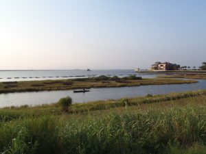
Rocky Bayou Aquatic Preserve – Choctawhatchee Bay, Niceville, Florida – Photo by Laura Tiu
September 17-24, 2016 was the nation’s 28th time to celebrate America’s coasts and estuaries during National Estuaries Week. This week helps us to remember to appreciate the challenges these coastal ecosystems face, along with their beauty and utility.
Estuaries, semi-enclosed bodies of water with both fresh and saltwater, dot the Gulf Coast of the United States from Brownsville Texas to Key West, Florida. These estuaries are important as they serve as drainage basins for many of the large river systems, and play a significant role in the nation’s seafood industry.
Florida’s six major Panhandle estuaries, which includes Perdido Bay, Pensacola Bay (including Escambia Bay), Choctawhatchee Bay, St. Andrew Bay, St. Joseph Bay and Apalachicola Bay, are unique ecosystems teeming with life and diversity. Critical habitat includes important seagrass beds that support both the larval and adult stages of fish and invertebrates. In Choctawhatchee Bay, there is also critical foraging habitat for the federally protected Gulf sturgeon (Acipenser oxyrinchus desotoi) and stream habitat for the endangered Okaloosa darter.
Choctawhatchee Bay is in Okaloosa and Walton counties in the Florida Panhandle. It is approximately 30 miles long and from three and a half to six miles wide, with a total area of 129 square miles. It is relatively shallow varying from 10 to 40 feet deep. Large portions of the western half of Choctawhatchee Bay are militarily restricted (Eglin Airforce Base). The Bay is fed by the Choctawhatchee River and numerous small creeks that feed into several bayous. The only opening to the Gulf of Mexico is the East Pass, which ironically is at the Western end of the Bay in Destin, Florida. This is where the saltwater and freshwater mix.
Continued industrial and residential development in the watershed regions that drain into many of these estuaries has impacted them in a number of ways. Pollution comes from storm water runoff, lawns, industry and farms. The shorelines are impacted by development, which causes sedimentation and in turn loss of vegetation. This reduces water clarity and habitat for wildlife.
Many organizations work to protect this estuary and reach out to others through education, restoration, and recreation events. Choctawhatchee Basin Alliance (CBA) is one such organization committed to ensuring sustainable utilization of the Choctawhatchee River and Bay. They, working with their partners, provide leadership for the stewardship of the Bay. Alison McDowell, director of the CBA, notes that 75-85% of commercially and recreationally important species that are caught in the Gulf spend part of their lifecycle in the Bay. McDowell says a key factor in the Bay’s health is monitoring the water quality and reducing erosion, and the Oyster Reef Restoration program started in 2006 does just that.
There are often opportunities for the general public to join in some of the conservation efforts taking place in the Bay. For more information, like the Okaloosa or Walton County Extension Facebook page.
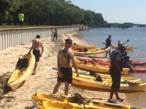
Kayaking Choctawhatchee Bay – Photo by Laura Tiu
by Carrie Stevenson | Sep 16, 2016
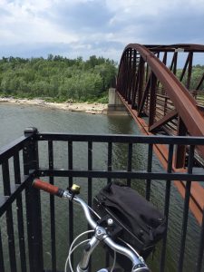
The bridge over the Winooski River was a scenic stop on our bicycle tour. Photo credit: Carrie Stevenson
If you told me earlier this summer that I would “accidentally” bike 18 miles one afternoon, I’d have laughed. I’ve always loved biking, but rarely have time for long distance rides. As part of the mobile workshops for an Extension professional development meeting in Burlington, Vermont, fifteen of us met up with the coordinator of Local Motion, a grassroots bike advocacy organization. Their mission is “to bring the joy of walking and biking within reach for all Vermonters by helping Vermont communities become great places to walk and bike.” The purpose of the tour was to get an on-the-ground lesson in community development and learn how the group has worked with residents to overcome challenges in implementing a successful project.
Burlington’s “Island Line Trail” is a classic rails-to-trails project–not unlike the Blackwater Heritage Trail in Santa Rosa County–that has resulted in significant economic development and increased use by area residents. The original rail service operated from 1899 to the early 1960’s. Since the 1990’s, 14 miles of railway has been converted to a biking/walking trail. Part of the Island Line’s charm is the diversity of scenery it encompasses.
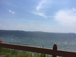
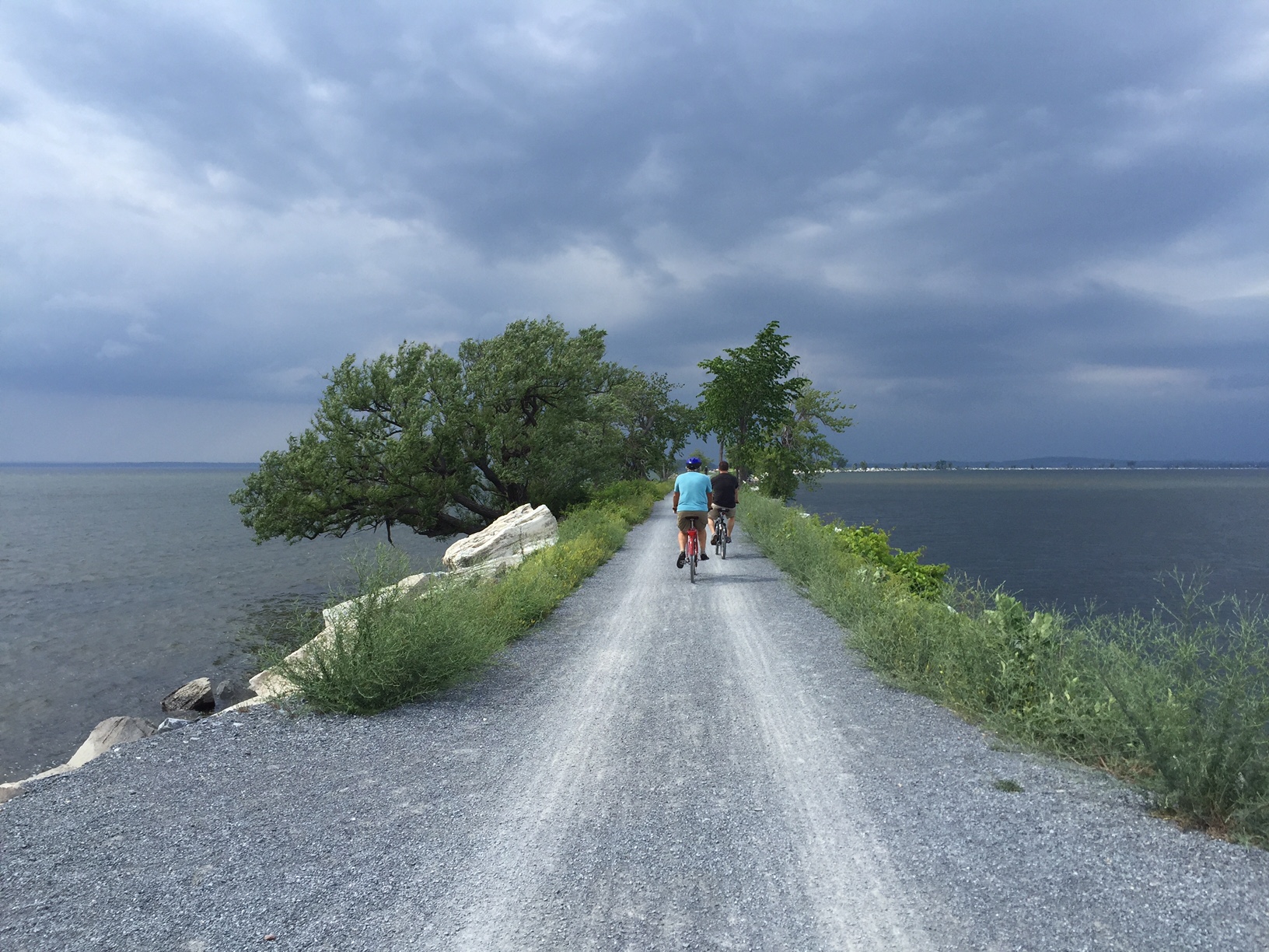
Sweeping views of Lake Champlain were part of what kept us riding far beyond our initial endpoint! Photo credit: Carrie Stevenson
Starting in the heart of downtown Burlington, there are museums, shops, and restaurants within blocks of the trail, many of which cater directly to and exist because of the trail users. The entire stretch runs adjacent to Lake Champlain, providing scenic views along the path. Throughout the trail there are residential areas (which are highly desired because of their proximity to the trail), public parks, and a community center. After crossing a bridge over the Winooski River, we embarked upon a 3-mile open causeway with sweeping views of Malletts Bay on both sides. The trail also includes one of the country’s few bike ferries, which is located where a swing bridge used to operate for the railway. It was the constantly changing scenery and surroundings that kept a handful of us going far beyond the initially planned 6-mile trip.
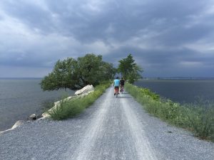
The causeway over Malletts Bay includes a bike ferry, one of the few in the country. Photo credit, Carrie Stevenson
In addition to providing a recreational trail for local residents and visitors, Local Motion is dedicated to promoting bicycle safety and education. Workshops for hesitant adult bikers interested in biking more attracted over 450 adults last year, while 7,300+ kids participated in bicycle safety camps and training. As a result of all of the activity, youth bike rentals increased by 43% in 2015 over the prior year.
Much of the success in Burlington is transferable to Florida. In the Panhandle, we are looking at connecting existing trails to create a large-scale multi-county, multi-state bicycle trail. The successes in Vermont were inspirational and instructional as we embark upon our new project and a design workshop in late September.