When I began working with terrapins 20 years ago, very few people in the Florida panhandle knew what they were – unless they had moved here from the Mid-Atlantic states. Since we initiated the Panhandle Terrapin Project in 2005 many more now have heard of this brackish water turtle.
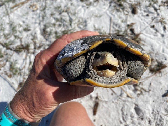
Ornate Diamondback Terrapin (photo: Dr. John Himes)
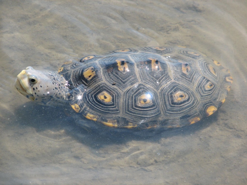
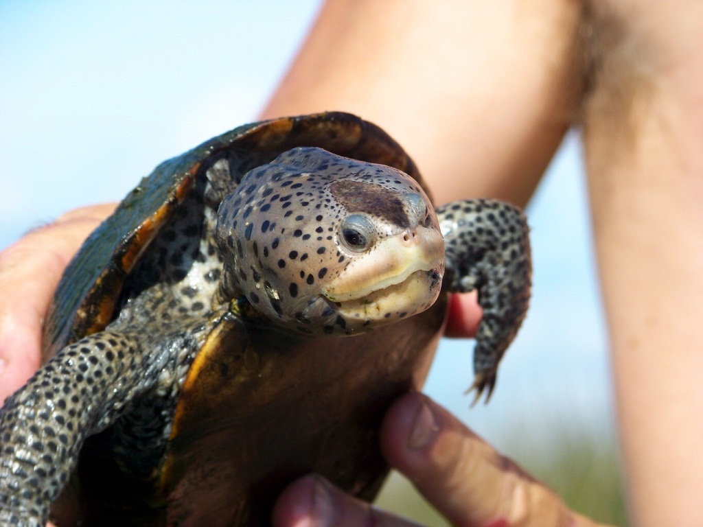
Diamondback terrapins are relatively small (10 inch) turtles that inhabit brackish environments such as salt marshes along our bays, bayous, and lagoons. They have light colored skin, often white, and raised concentric rings on the scales of their shells which give them a “diamond-backed” appearance. Some of them have dark shells, others will have orange spots on their shells.
The first objective for the project was to determine whether terrapins existed here, there was no scientific literature that suggested they did. We found our first terrapin in 2007, and this was in Santa Rosa County. We have since had at least one verified record in every panhandle county – diamondback terrapins do exist here.
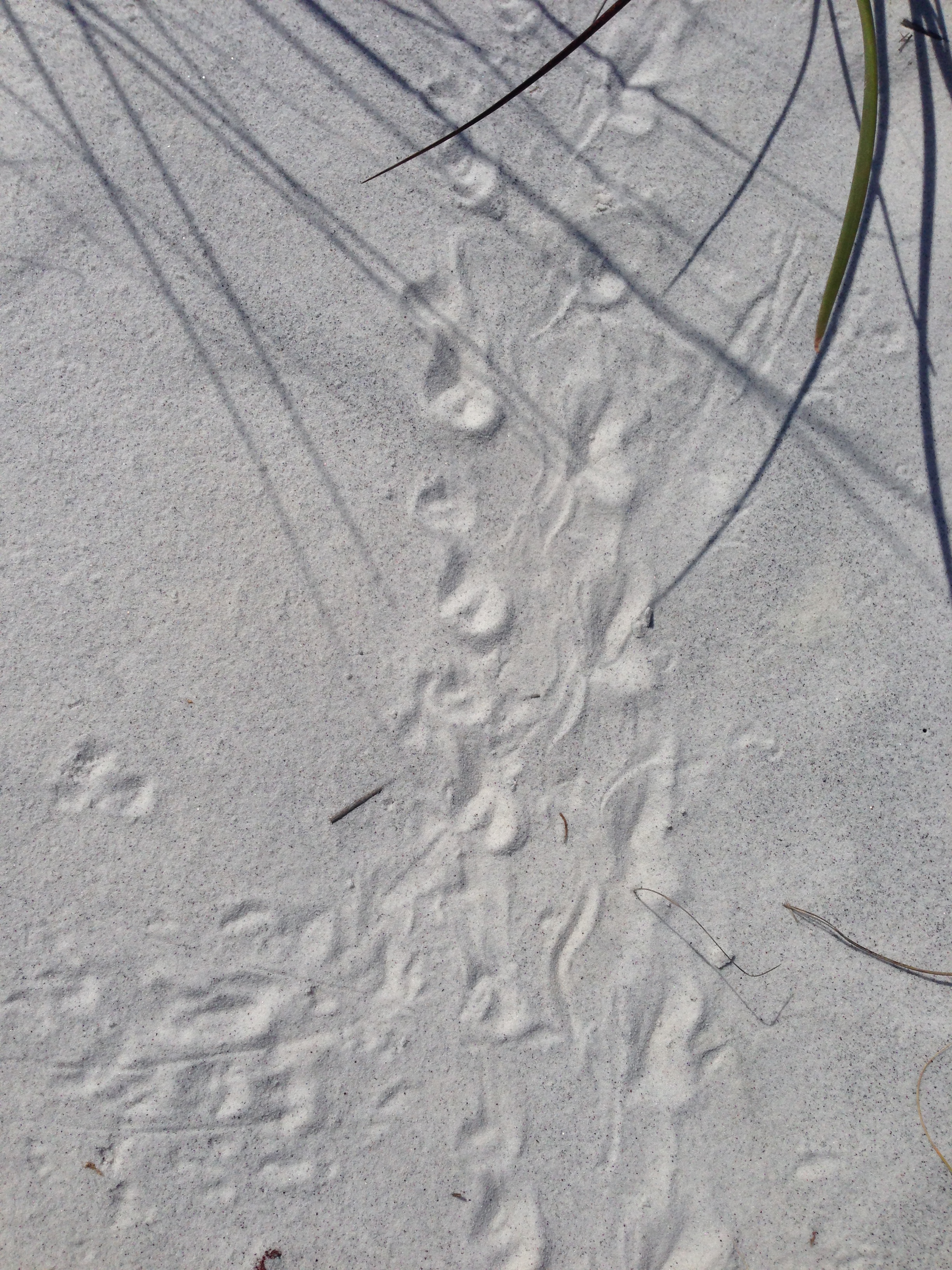
The second objective was to locate their nesting beaches. Terrapins live in coastal wetlands but need high-dry sandy beaches to lay their eggs. Volunteers began searching for such and have been able to locate nesting beaches in Escambia, Santa Rosa, Okaloosa, Bay, and Gulf counties. We continue to search in the other counties, and for additional ones in the counties mentioned above. Once a nesting beach has been identified, volunteers conduct weekly nesting surveys, providing data which can help calculate the relative abundance of terrapins in the area.
Tracks of a diamondback terrapin. Photo: Terry Taylor
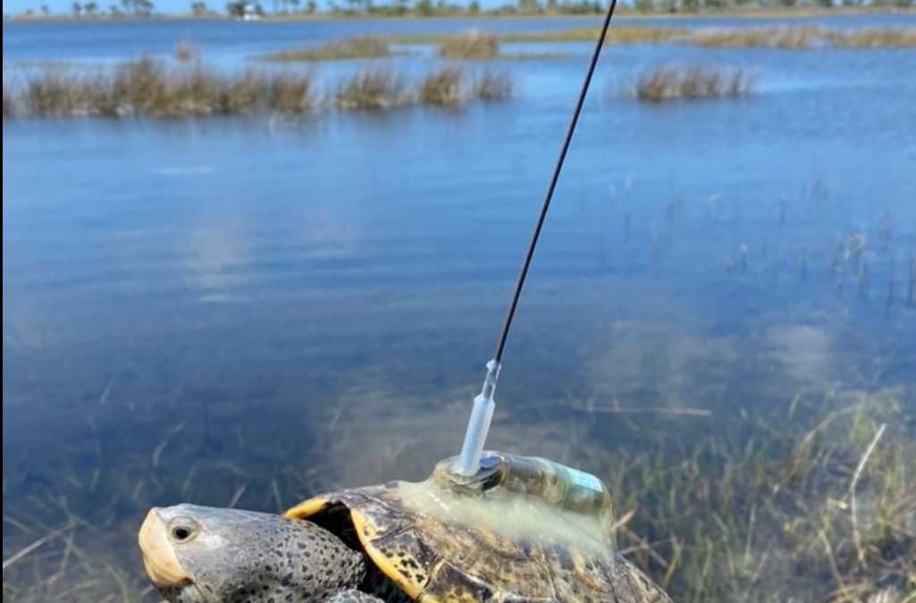
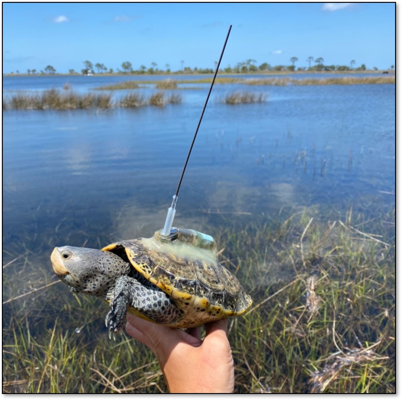
The third objective is to tag captured terrapins to determine their population, where they move and how they use habitat. We initially captured terrapins using modified traps and marking them using a file notching system. We then partnered with a research team from the U.S. Geological Survey and now include passive integrated transponder tags (PIT tags) that help identify individuals, satellite tags that can be detected from satellites and track their movements, and recently acoustic tags which can also track movement.
The fourth objective is to collect tissue samples for genetic studies. This information will be used to help determine which subspecies of terrapins are living in the Florida panhandle.
As we move into the summer season, more people will be recreating in our bays and coastal waterways. If you happen to see a terrapin, or maybe small turtle tracks on the beach, we would like you to contact us and let us know. You can contact me at roc1@ufl.edu. Terrapins are protected in Florida and Alabama, so you are not allowed to keep them. If you are interested in joining our volunteer team, contact me at the email address provided.
The bay scallop (Argopecten irradians) was once common in the lower portions of the Pensacola Bay system. However, by 1970 they were all but gone. Closely associated with seagrass, especially turtle grass (Thalassia testudinum), some suggested the decline was connected to the decline of seagrass beds in this part of the bay. Decline in water quality and overharvesting by humans may have also been a contributor. It was most likely a combination of these factors.
Scalloping is a popular activity in our state. It can be done with a simple mask and snorkel, in relatively shallow water, and is very family friendly. The decline witnessed in the lower Pensacola Bay system was witnessed in other estuaries along Florida’s Gulf coast as well. Today commercial harvest is banned, and recreational harvest is restricted to specific months and to the Big Bend region of the state. With the improvements in water quality and natural seagrass restoration, it is hoped that the bay scallop may return to lower Pensacola Bay.
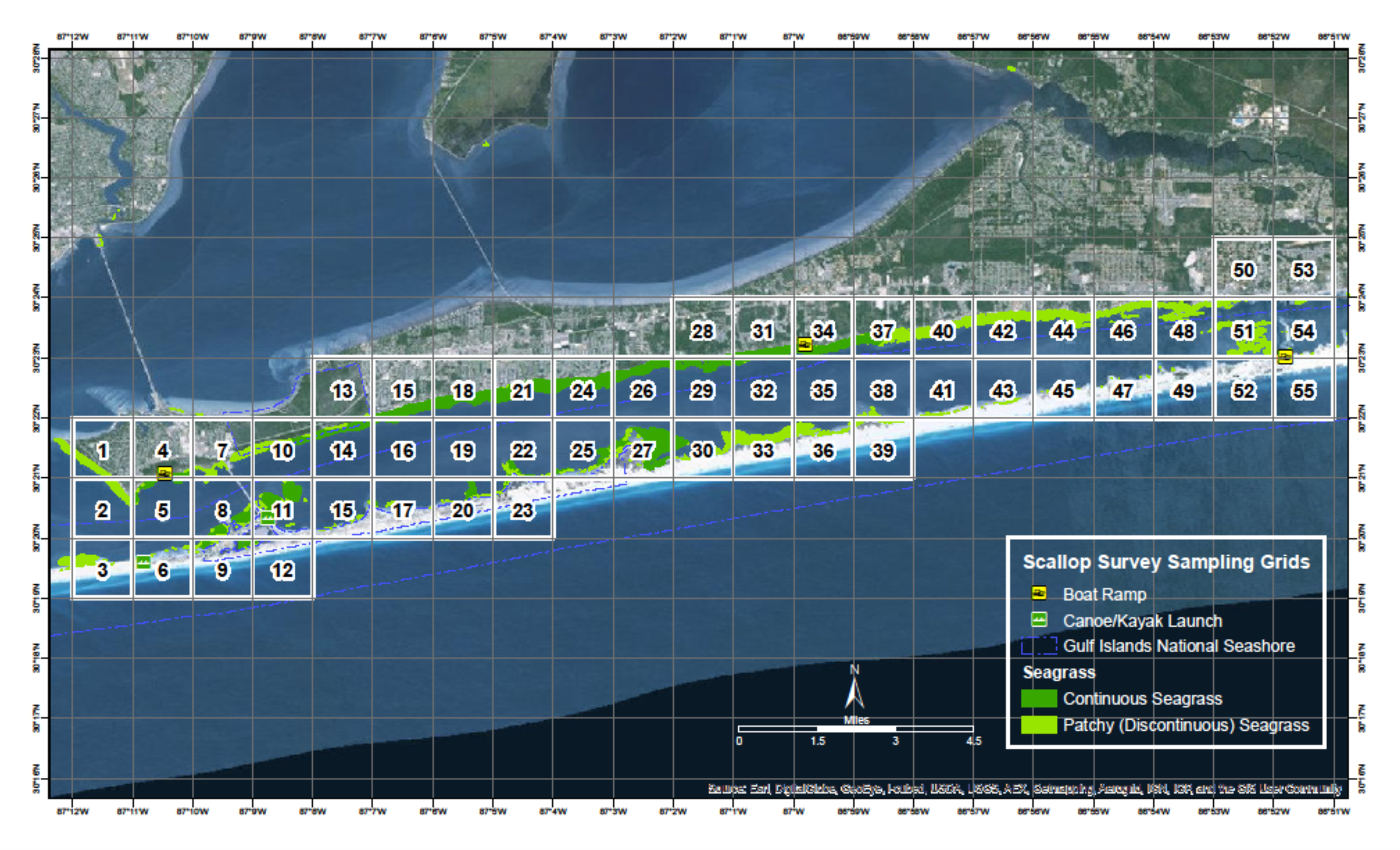
Since 2015 Florida Sea Grant has held the annual Pensacola Bay Scallop Search. Trained volunteers survey pre-determined grids within Big Lagoon and Santa Rosa Sound. Below is the report for both the 2024 survey and the overall results since 2015.
Methods
Scallop searchers are volunteers trained by Florida Sea Grant. Teams are made up of at least three members. Two snorkel while one is the data recorder. More than three can be on a team. Some pre-determined grids require a boat to access, others can be reached by paddle craft or on foot.
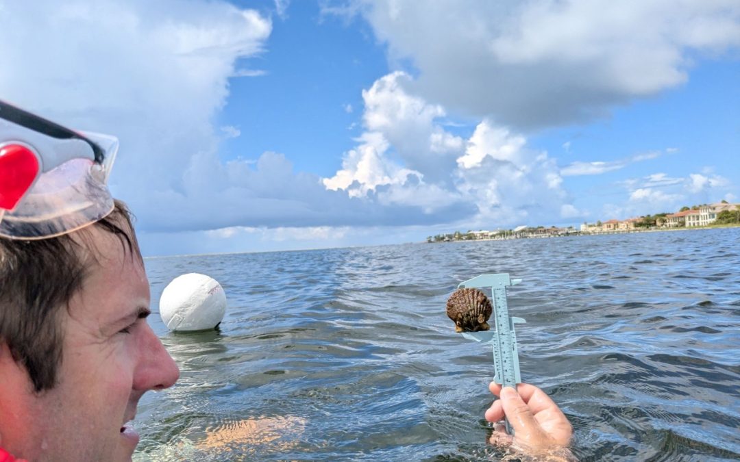
Once on site the volunteers extend a 50-meter transect line that is weighted on each end. Also attached is a white buoy to mark the end of the line. The two snorkelers survey the length of the transect, one on each side, using a 1-meter PVC pipe to determine where the area of the transect ends. This transect thus covers 100m2. The surveyors record the number of live scallops they find within this area, measure the height of the first five found in millimeters using a small caliper, which species of seagrass are within the transect, the percent coverage of the seagrass, whether macroalgae are present or not, and any other notes of interest – such as the presence of scallop shells or scallop predators (such as conchs and blue crabs). Three more transects are conducted within the grid before returning.
The Pensacola Scallop Search occurs during the month of July.
2024 Results
A record 168 volunteers surveyed 15 of the 66 1-nautical mile grids (23%) between Big Lagoon State Park and Navarre Beach. 152 transects (15,200m2) were surveyed logging 133 scallops. An additional 50 scallops were found outside the official transect for a total of 183 scallops for 2024.
2024 Big Lagoon Results
75 volunteers surveyed 7 of the 11 grids (64%) within the Big Lagoon. 67 transects were conducted covering 6,700m2.
101 scallops were logged with an additional 42 found outside the official transects. This equates to 3.02 scallops/200m2. Scallop searchers reported blue crabs and conchs, both scallop predators, as well as some sea urchins. All three species of seagrass were found (Thalassia, Halodule, and Syringodium). Seagrass densities ranged from 5-100%. Macroalgae was present in six of the seven grids (86%) but was never abundant.
2024 Santa Rosa Sound Results
93 volunteers surveyed 8 of the 55 grids (14%) in Santa Rosa Sound. 85 transects were conducted covering 8,500m2.
32 scallops were logged with an additional 8 found outside the official transects. This equates to 0.76 scallops/200m2. Scallop searchers reported blue crabs, conchs, and sand dollars. All three species of seagrass were found. Seagrass densities ranged from 50-100%. Macroalgae was present in five of the eight grids (62%) and was abundant in grids surveyed on the eastern end of the survey area.
2015 – 2024 Big Lagoon Results
Year
No. of Transects
No. of Scallops
Scallops/200m2
2015
33
0
0.00
2016
47
0
0.00
2017
16
0
0.00
2018
28
0
0.00
2019
17
0
0.00
2020
16
1
0.12
2021
18
0
0.00
2022
38
0
0.00
2023
43
2
0.09
2024
67
101
3.02
Big Lagoon Overall
323
104
0.64
2015 – 2024 Santa Rosa Sound Results
Year
No. of Transects
No. of Scallops
Scallops/200m2
2015
01
0
0.00
2016
01
0
0.00
2017
01
0
0.00
2018
01
0
0.00
2019
01
0
0.00
2020
01
0
0.00
2021
20
0
0.00
2022
40
2
0.11
2023
28
2
0.14
2024
85
32
0.76
Santa Rosa Sound Overall
1731
36
0.42
1Transects were conducted during these years but data for Santa Rosa Sound was logged by an intern with the Santa Rosa County Extension Office and is currently unavailable.
Discussion
Based on a Florida Fish and Wildlife Research Institute publication in 2018, the final criteria are used to classify scallop populations in Florida.
Scallop Population / 200m2
Classification
0-2
Collapsed
2-20
Vulnerable
20-200
Stable
Based on this, over the last nine years we have surveyed, the populations in lower Pensacola Bay are still collapsed. However, you will notice that in 2024 the population in Big Lagoon moved from collapsed to vulnerable for this year alone.
There are some possible explanations for this.
The survey effort in Big Lagoon was stronger than Santa Rosa Sound. 75 volunteers surveyed 7 of the 11 grids. This equates to 11 volunteers / grid surveyed and 64% of the survey area was covered. With Santa Rosa Sound there were 93 volunteers who surveyed 8 of the 55 grids. This equates to 12 volunteers / grid surveyed but only 14% of the survey area was covered. Most of the SRS grids surveyed were in the Gulf Breeze/Pensacola Beach area. More effort east of Big Sabine may yield more scallops found.
There is the possibility of different teams counting the same scallops. Each grid is 1-nautical mile, so the probability of one team laying their transect over an area another team did is low, but not zero.
It is known that scallops have periodic population booms. Our search this year may have witnessed this. We will know if encounters significantly decrease in 2025.
Whether there was double counting this year or not, the frequency of encounter was much higher than in previous years. There were multiple reports from the public on social media about scallop encounters as well, and in some places we did not survey. It is also understood that scallops mass spawn. So, high density populations are required for reproductive success. The “boom” we witnessed this year suggests that there is a population of scallops – albeit a collapsed one – in our bay. It is important for locals NOT to harvest scallops from either body of water. First, it is illegal. Second, any chance of recovering this lost population will be lost if the adult population densities are not high enough for reproductive success.
Acknowledgements
We would like to thank ALL 168 volunteers who surveyed this year. We obviously could not have done this without you.
Below are the “team captains”.
Harbor Amiss Glen Grant Eric Stone
David Anderson Phil Harter Neil Tucker
Laura Baker Gina Hertz Christian Wagley
Melinda Bennett Sean Hickey Jaden Wielhouwer
Samantha Bergeron (USM class) John Imhof Keith Wilkins
Cheri Bone Jason Mellos Christy Woodring
Cindi Cagle Greg Patterson
Cher Clary Kelly Rysula
A team of scallop searchers celebrates after finding a few scallops in Pensacola Bay.
Volunteer measures a scallop he found. Photo: Abby Nonnenmacher
Rick O’Connor Florida Sea Grant; Escambia County
Thomas Derbes II Florida Sea Grant; Santa Rosa County
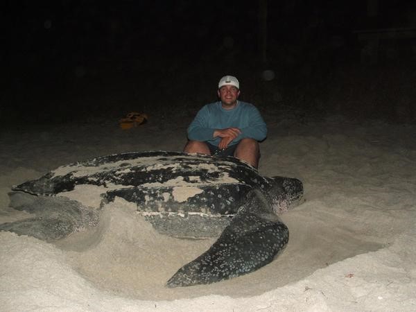
The leatherback sea turtle is the largest of the five species that have been found in the northern Gulf of Mexico. With a carapace (top shell) length between 6-7 feet and weighing between 800-1000 pounds it is truly a magnificent creature. Any encounter with them is amazing.
Most encounters occur with fishermen or divers who are out searching for artificial reefs to fish or dive. Though very rare, they have been known to nest in this area. They feed exclusively on jellyfish and will follow them close to shore if need be. But what do leatherbacks do with most of their time? Do they hang offshore and follow jellyfish in? Do they circle the entire Gulf of Mexico and we see them as they pass? Based on past studies, many encounters with this turtle occur in the warmer months. They often become entangled in commercial fishing longlines set in the central Gulf of Mexico. But what do they do during the fall and winter? One of the tagging projects presented at a recent workshop tried to answer that question.
The project was led by Dr. Christopher Sasso of the National Oceanic and Atmospheric Administration. The tag chosen for this was a satellite tag. Since the leatherback must surface to breath air, and often is found near the surface following jellyfish, orbiting satellites would be able to follow them. As we mentioned in Part 1, catching the creature is step 1, and catching a six-foot 1000-pound sea turtle is no easy task.
The team used a spotter aircraft to locate the turtles. Once found, the pilot would radio the chase boat who would zip in with a large net. The net was connected to a large metal hoop and was designed to give way once it was around the turtle. Once in the net the turtle was hauled onto a small inflatable boat where the work of tagging could be done. They would measure the animal, take blood samples, place a PIT tag within them (similar to a microchip in your pet) and then attach the satellite tag by a tether to the tail end of the turtle before releasing it. The entire operation took less than 30 minutes.
Between 2015-2019 19 leatherbacks were tagged in the northern Gulf. 17 of these were females and 2 were males. Data obtained from these tags ranged between 63 and 247 days at liberty. The behavior the team noticed was divided into foraging behavior (feeding on jellyfish) and transiting behavior (direct swimming ignoring all).
The turtles foraged in this part of the Gulf until the fall season. At that point most of them moved south along the Florida shelf, past the western peninsula of the state, heading towards the Keys. A few chose to swim directly south against the Loop Current, and a small number remained in the area.
Those moving along the Florida shelf appeared to be foraging as they went. Those crossing the open Gulf may have foraged some but seemed to be focused on getting south to the nesting beaches. Almost all of the turtles entered the Caribbean on the east side of the Yucatan channel, following the currents, with their final destination being their nesting beaches. When they returned, they did so in the warmer months and used the western side of the channel – again following the currents – until they once again reached the northern Gulf and foraging began again. One interesting note from this study, the two males tagged did not leave the Gulf.
The tagging studies do show that leatherbacks use the Gulf of Mexico year-round. They usually head south to the Caribbean when it gets colder and use the currents to do so. It is during the warmer months we are most likely to see them here foraging on jellyfish. It is an amazing experience to encounter one of these large turtles. I hope you get to experience it one day.
Satellite tracks of leatherback movement in the GoM. Red (2015), Blue (2018), Black (2019).
Image: Sasso (et.al.) 2021.
Reference
Sasso, C.R., Richards, P.M., Benson, S.R., Judge, M., Putman, N.F., Snodgrass, D., Stacy, B.A. 2021. Leatherback Sea Turtles in the Eastern Gulf of Mexico: Foraging and Migration Behavior During the Autumn and Winter. Frontiers in Marine Science., Vol. 8., https://doi.org/10.3389/fmars.2021.660798.
Recently I attended a workshop on wildlife tagging projects. Researchers from across the Gulf of Mexico who had projects going on in the northern Gulf were invited to present their updates. I was there to help present what we have learned about diamondback terrapins but there were numerous other talks, and the results were fascinating. Fascinating enough that I thought the public would be interested in them as well. Most of the presentations were on fish or reptiles, but the fish included interesting species such as whale sharks, tiger sharks, cobia, and tarpon. So, I am going to run a series of posts on the different species along with another series on barrier island wildlife.
I thought I would start with an introduction on the methods of wildlife tagging and why scientists tag animals. Some of the reasons may seem obvious, but with today’s modern tags, there is a lot of information scientists can gain from doing this.
Why do they tag?
With the types of tags they used when I was in school there were a few things that you could learn. (1) How far do the animals range, (2) how fast they reached those locations, (3) some idea of live longevity – you at least knew how long they were “at freedom”. With these data you could get a better idea of what their habitat range was and how they used the habitat. Some, like blue sharks, may move great distances all year long. Others, like nurse sharks, may not move more than a few miles from the point where they were tagged. Others may move seasonally, spending summer in one region and winter in another. All of these data are useful to resource managers responsible for maintaining the species population.
With the more modern electronic tags, they can learn such things as how deep they dive, how long they stay at depth, what water temperatures they may frequent, what salinity they prefer, and let you know where the animal is at any given moment in time. Today’s tags are pretty amazing.
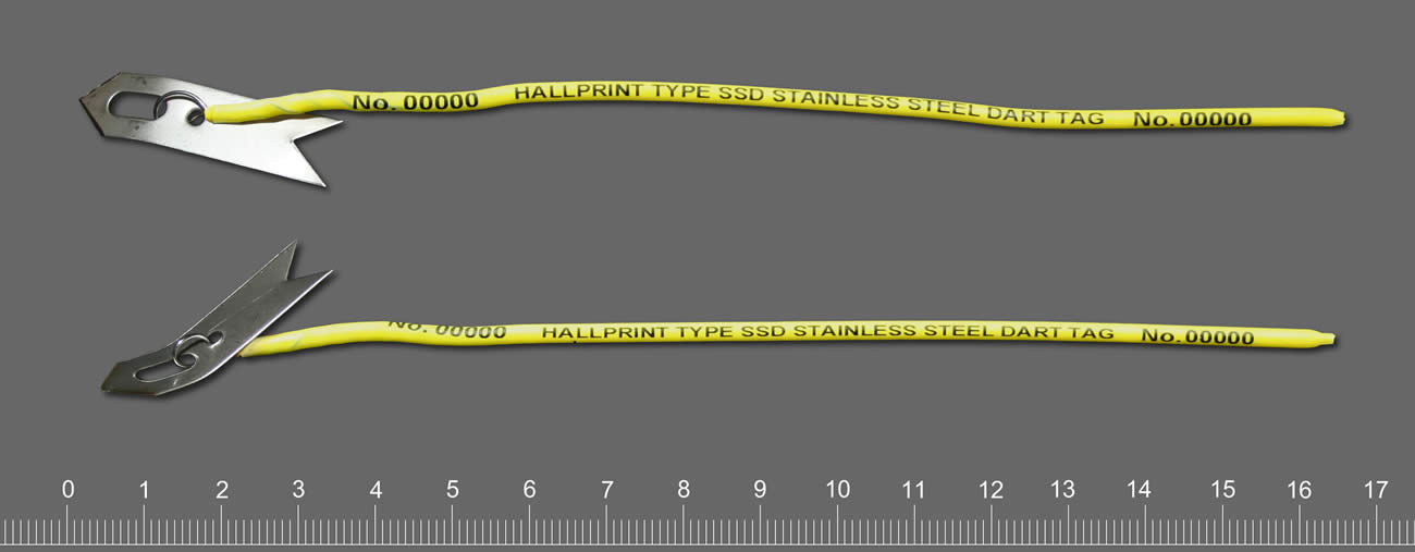
This tag is similar to the ones we used in the 1980s on sharks. They provide a number for individual identification. Ours also had a capsule with a note on water resistant paper.
Photo: Hallprint.
How do they tag?
Well… step one to answering this question is HOW DO YOU CATCH THE ANIMAL? – not as easy as you think. Whale sharks and leatherback sea turtles are quite a handful. If your target species is something like a white shark, tiger shark, diamondback rattlesnake, there is an extra danger added. As you plan a method for your safety, you must also plan a method for their safety. The objective is not harm or kill the creature – you will learn nothing from this. When I began my career, I saw a program on how they tagged polar bears in the 1980s. They would fly over the ice in a helicopter looking for the bears. When the bears saw the helicopter, they would run for the safety of water. The scientist would try to shoot a dart into the animal to put it asleep long enough to get a tag on it. BUT if you overdosed the bear, and it made it to the water, it could drown. So, from the air, they had to gauge the weight of the bear, guess what amount of the drug to shoot, and hope they were right. If the bear did fall asleep, how “asleep was it? Did you give ENOUGH drug? Polar bears can be very dangerous. In the episode I watched the bear was asleep, but the researchers did mention that they will “play sleep” and you need to be ready. Such was the world of wildlife tagging 40 years ago.
One of the things that was also discussed when I was in school was what type of tag you were going to place on the animal. They did not have the neat tools they have now. Most tags had a capsule with a piece of paper, sometimes written in multiple languages, to call said person and report where and when they found the animal. There was usually a monetary award for doing so, or sometimes a hat or T-shirt. I remember the hat you got for reporting a tagged redfish was really neat, but I never caught a tagged one.
You did not want to place a tag that would alter the natural behavior of the animal. In the case of the polar bear, they would place an ear tag and paint a large number on its side in black paint. This made sense from the biologist’s side – flying over the ice you could see the large black “3” on a bear and know the individual. But that large black number could also be seen by their prey. Not good. I saw researchers painting the shells of gopher tortoises with all sorts of neon colors to make detection by them easier, but easier for their predators as well.
Radio tagging was used 40 years ago. This involves capturing the animal (as we have already seen – fun in itself), putting it asleep and attaching/inserting a radio tag. This tag provides a radio signal that can be detected by a receiver carried by the research holding an antenna walking/driving around following the animal. You had to be within range to hear the signal and – honestly – good at detecting the signal. Some researchers were better at this than others. As you can imagine this was only as good as your ability to keep up with the animal. At some point your car/boat would need fuel, or the animal crossed a river you could not. It provided some good data, but there were limits.
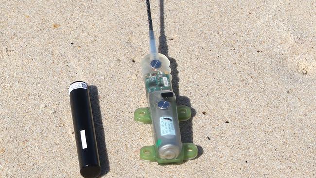
Today modern tags have solved a lot of these issues. Some new tags do not have typed notes but sensors that can detect the elevation/depth, temperature/salinity, all sorts of information that was unknown in my college days. These tags can be retrieved and downloaded on a computer to give a much better idea of how the animal spends its time and what it seeks.
This modern shark tag could provide additional information such as diving depth, water temperature, and more.
Satellite tags work well for creatures who surface frequently – sea turtles, whales, whale sharks. Satellites can detect them, and you can follow their movements/habitat preferences as they are actually using them.
For species at depth, like some sharks, cobia, tarpon, etc. there are now acoustic tags. The tag emits a signal that is detected by an array of receivers the researchers place in the environment. As the animal passes within range of the receiver it is detected, and the downloaded data gives a similar picture of how the animal uses the environment. A couple of neat things about acoustic tags are that (a) you can track satellite tagged animals while they are diving, and (b) your receivers can detect other species tagged by other researchers and let them know where their creature was. This was one reason for the workshop – so, everyone could meet everyone else and know who has tagged what and how to share information.
No tag is permanent. All are designed to fall off. Battery power will eventually fail. But no animal is stuck with this all of their lives as they could have been when I was in school. In future articles we will look at the results of some of these studies.
This tag with an antenna can be detected by a satellite and tracked real time.
Photo: USGS
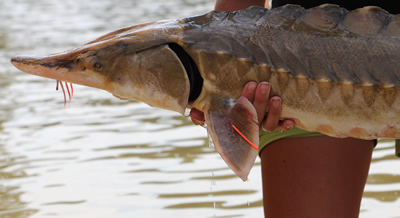
Mark Twain once said – “Everyone talks about the weather, but no one does anything about it.” A similar statement could be made about the Gulf Sturgeon – “Everyone talks about the Gulf sturgeon, but on one has actually seen one.” Those along the coast who have a dock, pier, seawall, or have placed a marina, artificial reef, or oyster farm over state submerged lands, have certainly heard about this fish. It is a portion of the permit in each case. Heck, maybe they have seen one. But it is a fish that many know about but seems elusive to encounter.
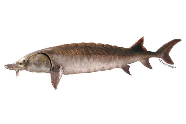
Left-facing Gulf sturgeon illustration. Lighter brown than Atlantic sturgeon. Credit: Jack Hornady for NOAA Fisheries.
The Gulf sturgeon (Acipenser oxyrinchis desotoi) is one of 27 species of sturgeon found worldwide. It is a subspecies of the Atlantic sturgeon. These are ancient fish, and they look it. Sturgeons are large, reaching lengths of up to eight feet and 300 pounds. They have armored looking scutes embedded into their skin, giving them a “dinosaur” appearance. They have a heterocercal caudal fin that resembles a shark. And like sharks, they have a cartilaginous skeleton and a spiral valve within their digestive tract. Their head has a pointed snout with whisker-like structures called barbels, which are used for detecting food buried in the sand, and they lack teeth. They have been swimming in our oceans since the era of the dinosaurs, about 225 million years.
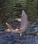
Sturgeons are anadromous fish, meaning they (like salmon) spend their adult lives in salt water, traveling miles upriver to their location of their birth to lay eggs. The Gulf sturgeon spends the colder months (November through February) inhabiting our bays and the nearshore Gulf of Mexico in waters less than 100 feet. Now is the time when you may encounter one near the coast. Because they eat very little while in the river systems, they gorge on benthic invertebrates during the winter. They spend most of their time over sand flats and sand bars, using their barbels to detect a variety of buried invertebrates. When sturgeon sense warmer months coming, they begin their long migrations up the inland rivers seeking the area where they were born. At this time, they leap from the water like mullet and make splashes that can be heard from a long distance. They are famous for this in the Suwannee River and have, at times, been a concern for boaters and jet skiers. Many boaters have had to go to the hospital due to collisions with leaping sturgeon.
The Gulf Sturgeon.
Photo: U.S. Geological Survey
Once they reach the spawning grounds, if conditions are right – temperature, water flow, and pH – the female will lay between 250,000 – 1,000,000 eggs which will become fertilized by the smaller males. Most eggs will not survive, but for those that do, the cycle will begin again with the trek back towards the Gulf of Mexico beginning in September.
Why are they declining?
Early in the 20th century they were sought after for their meat and fertilized eggs (caviar). Most of the rivers within their range (which is between the Mississippi and Suwannee Rivers) have been damned, dredged, or both. Dams impede their ability to reach their nursery grounds and dredging can reduce the required conditions to stimulate breeding, or literally bury their eggs. Between these human activities, their numbers declined drastically. In 1991 they were listed both as a federally and state threatened species and have been protected and monitored ever since. The best population, and best chance to encounter one, is in the Suwannee River. This river has been left basically pristine and has not had the habitat altering activities of the others. Locally, they are found in the Escambia, Blackwater, and Yellow Rivers.
Winter is the time to see them in the lower parts of our bay. Maybe you will be lucky enough to encounter one.
References
The Gulf Sturgeon. Florida Fish and Wildlife Conservation Commission.
Diamondback terrapins are the only resident turtle within brackish water and estuarine systems. Their range extends from Massachusetts to Texas but, prior to 2005, their existence in the Florida panhandle was undocumented. The Panhandle Terrapin Project was developed to first determine whether terrapins exist in the panhandle (Phase I) and, if so, what is their status (Phase II and III).
The project began at the Marine Science Academy at Washington High School (in Pensacola) in 2005. Between 2005 and 2010 the team was able to verify at least one record in each of the panhandle counties. For Phase II we used what we called the “Mann Method” to determine the relative abundance of terrapins in each area. To do this we needed to conduct assessments of nesting activity in each county. In 2012 the project moved from Washington High School to Florida Sea Grant. At that time, we developed a citizen science program to conduct Phase II of this project. Effort first focused on Escambia and Santa Rosa counties, but in recent years has included Okaloosa County. Florida Sea Grant now partners with the U.S. Geological Survey (based out of Gulf County) to assist with Phase II and lead Phase III, which is estimating populations using mark-recapture methods, as well as satellite tagging to better understand movements and habitat use. The focus of Phase III has been Gulf County, but tagging has occurred in Okaloosa and Escambia counties.
Over the years we have trained 271 volunteers who have conducted thousands of hours of nesting surveys and helped obtain a better picture of the status of diamondback terrapins in the Florida panhandle. Here are the 2023 project results.
Results from 2023
We trained 67 volunteers; 35 (52%) of which participated in at least one nesting survey.
The volunteers conducted 196 surveys logging 212 hours.
During those surveys terrapins (or terrapin sign) were encountered 43 times; a Frequency of Encounter (FOE) of 22%.
Three terrapins were tagged. Two from Okaloosa and one from Escambia. All but two of the nine primary survey beaches saw nesting activity (78%). One new nesting beach was discovered.
Escambia County
Two nesting beaches. 47 surveys. 7 encounters (FOE = 15%).
The Mann Method assumes the sex ratio is 1:1 (male: female) but recent studies suggest the ratio may be as high as 5:1 (male: female). Based on these two rations the number of terrapins estimated to be using these beaches ranged from 4-36.
One terrapin (“Dollie”) was tagged. Fire ants and torpedo grass were reported on some beaches.
Santa RosaCounty
Three nesting beaches. 68 Surveys. 14 encounters (FOE = 21%).
The number of terrapins estimated to be using these beaches ranged from 6-30.
No terrapins were captured, though one was seen nesting. No invasive species were reported from the nesting beaches.
OkaloosaCounty
Four nesting beaches. 67 surveys. 21 encounters (FOE = 31%).
The number of terrapins estimated to be using these beaches ranged from 2-66.
Two terrapins were tagged (“Kennedy” and “Molly”). Phragmites were reported from all beaches.
Walton County
Walton county currently does not have a volunteer coordinator and surveys are not occurring at this time. We are working with an individual who may take the lead on this.
BayCounty
This team is just beginning and currently there are no primary beaches. The team focused on five beaches encountering terrapin nesting activity on one of them. They conducted a total of 14 surveys encountering terrapin tracks on 1 of those (FOE = 7%). The estimated number of terrapins using this beach ranged from 4-12.
Baldwin County Alabama
Due to the proximity of terrapin habitat and nesting beaches at the Alabama/Florida line, and the possibility of terrapins using habitat in both states, a team was developed in Baldwin County Alabama this year. The team began conducting Phase I surveys and encountered one deceased terrapin. No nesting beaches have been identified at this time.
Summary
The results of this year’s surveys suggest that, based on the number of nesting beaches we know of, there are anywhere from 2-66 terrapins utilizing them. Again, two of the primary beaches did not have nesting activity this year. USGS tagging studies will provide better population estimates and a better understanding of how these animals are utilizing these habitats. The current population estimate for Gulf County is a little over 1000 individuals and most are showing relatively small range of habitat utilization, although two individuals in the western panhandle moved from one county to the neighboring one.
Training for volunteers occurs in March of each year. If you are interested in participating, contact Rick O’Connor – roc1@ufl.edu.