
by Rick O'Connor | Oct 4, 2024
One of the top concerns with residents in our communities is water quality. Surveys I have conducted with the public support this statement. One of the top concerns with water quality in the coastal areas is health advisories. These are issued when concentrations of selected fecal bacteria are too high.
In coastal areas, the selected bacteria are Enterococcus. It is important to note that Enterococcus bacteria are found in the digestive systems of birds and mammals. So, its presence does not automatically mean there is human waste in the water. However, there are pathogens associated with bird and mammal waste humans should be concerned about. And very high concentrations are most likely due to human waste. Science is working on additional methods to confirm high levels of Enterococcus are human. It is assumed that these will one day be used.
Enterococcus bacteria are used in coastal waters due to their ability to tolerate higher salinity. Some species, such as E. coli, that are used in freshwater systems die in saline ones. This suggests that the waste is not there, when in fact it is. It is also important to know that Enterococcus bacteria in themselves are not health concern for us. They are in our digestive tracts. But their presence in the water indicates that waste is present and there are pathogens in this waste that are of concern – hence the advisories issued.
In this series we will look at three methods we can use to help reduce human waste from entering our local waterways. Those are (1) maintaining your septic system, (2) converting your septic system to sewer, and (3) maintaining your sewer lines. We will begin with maintaining your septic system.
Septic systems have been used in rural and suburban communities where sewer systems have not been available for decades. Even today, the growth of new neighborhoods is outpacing the sewer infrastructure to support them. Many of these new communities are using septic systems. If properly placed and maintained, septic systems can work well. But many are not placed in good locations, and most are not maintained.
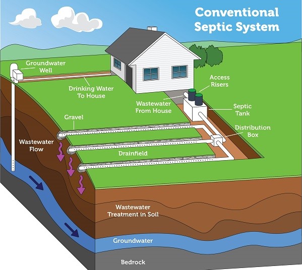
A conventional septic system is composed of a septic tank and a drainfield, where most of the wastewater treatment takes place. Image: US EPA
The system begins with the water leaving your home and entering a large tank made of concrete, fiberglass, or polyethylene buried in the yard. The average size of these tanks is 1000 gallons, but – depending on the number of bedrooms and bathrooms in the house, they could be larger. Here the sewage sits. Over time the solid waste will settle on the bottom (sludge) while the fats, oils, and grease float to the surface. The liquid layer in the middle (effluent) will flow from the tank into a series of smaller perforated drainpipes that slowly discharge into a drain field. A properly designed drain field will have a layer of sand that will allow draining of the effluent to occur.
Let’s talk about how to maintain this system.
- Do not overload the system with too much water. The tank is designed for a specific number of bedrooms/bathrooms. Overusing water can fill the tank and initiate leaking before the sewage has had time to settle. Watch your water use.
- Watch what you are flushing down the drain. Fats, oils, grease, and even milk will solidify and clog the lines. There are many products that describe themselves as “flushable”. They are, but they are not biodegradable. These two will cause clogs and backups in the system. Some harsh cleaning products can harm the bacteria within the tank who are breaking down the waste – these should be avoided. Also avoid using the garbage disposal. Septic systems were designed for water and sewage, not garbage and food. Compost your food waste instead.
- Periodically have your tank pumped and inspected. This is a step that many do not follow and can lead to leaking of untreated sewage into local waterways. It is recommended that you have your septic tank pumped and inspected once every 3-5 years. There are several businesses in your area who do this type of work. They can also provide advice on how to better maintain your specific system.
- Protect your drain field. Do not drive over this area of your lawn. Vehicles can compact the porous soil needed for efficient percolation and possible crack pipes. Planting trees and shrubs in this area can introduce roots into the lines, plant shallow root plants only. Design your landscape so that rainwater does not flow over the drain field during storms. The draining of your system is designed to be a slow process, allowing both physical and biological treatment of the waste to occur before reaching any water source. Rain and flooding conditions impede this from happening.
Developing a septic maintenance plan for your property can help reduce the number of health advisories your community will see. For more information contact your county health department or extension office.
by Rick O'Connor | Aug 30, 2024
Introduction
The bay scallop (Argopecten irradians) was once common in the lower portions of the Pensacola Bay system. However, by 1970 they were all but gone. Closely associated with seagrass, especially turtle grass (Thalassia testudinum), some suggested the decline was connected to the decline of seagrass beds in this part of the bay. Decline in water quality and overharvesting by humans may have also been a contributor. It was most likely a combination of these factors.
Scalloping is a popular activity in our state. It can be done with a simple mask and snorkel, in relatively shallow water, and is very family friendly. The decline witnessed in the lower Pensacola Bay system was witnessed in other estuaries along Florida’s Gulf coast as well. Today commercial harvest is banned, and recreational harvest is restricted to specific months and to the Big Bend region of the state. With the improvements in water quality and natural seagrass restoration, it is hoped that the bay scallop may return to lower Pensacola Bay.
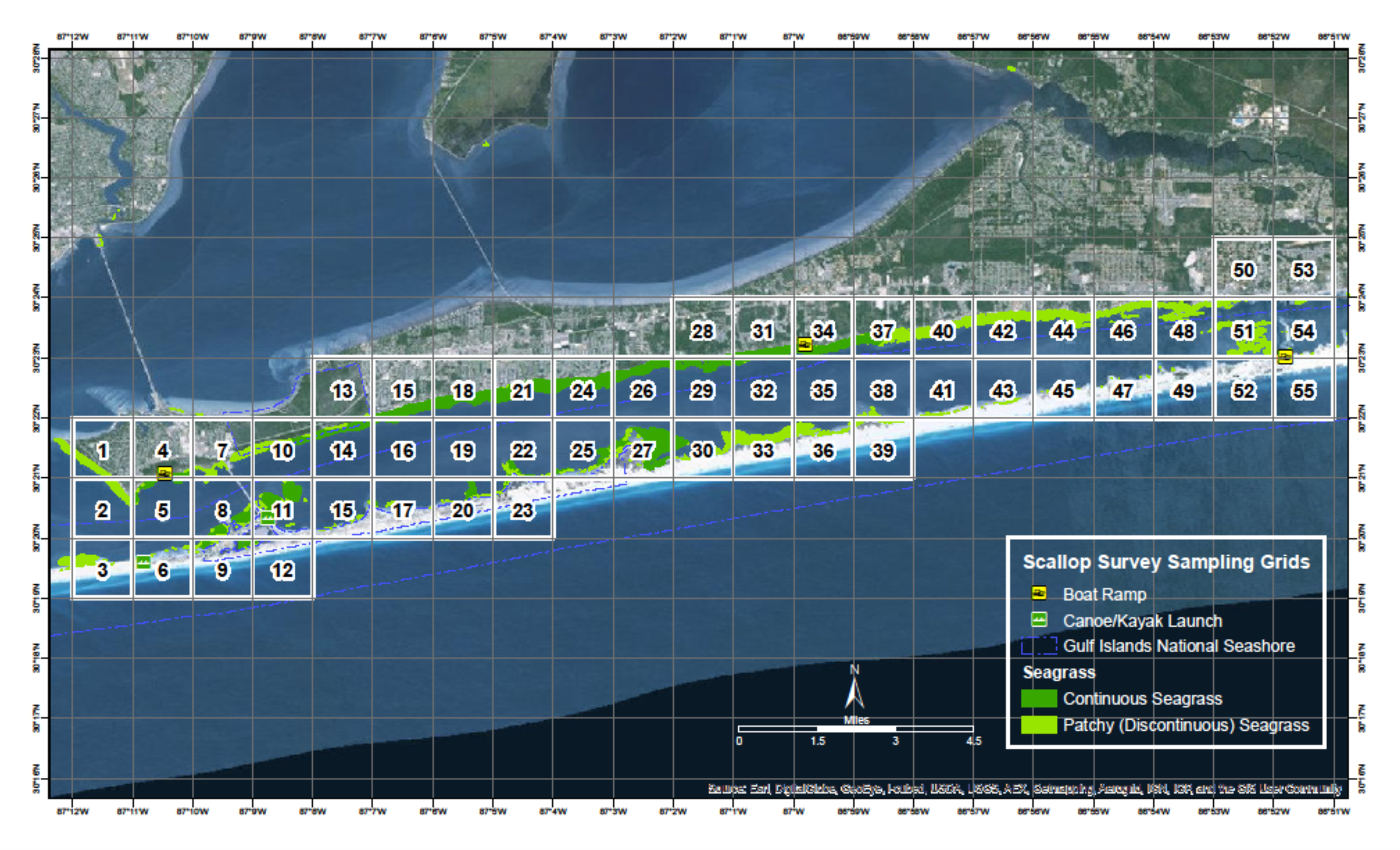
Since 2015 Florida Sea Grant has held the annual Pensacola Bay Scallop Search. Trained volunteers survey pre-determined grids within Big Lagoon and Santa Rosa Sound. Below is the report for both the 2024 survey and the overall results since 2015.
Methods
Scallop searchers are volunteers trained by Florida Sea Grant. Teams are made up of at least three members. Two snorkel while one is the data recorder. More than three can be on a team. Some pre-determined grids require a boat to access, others can be reached by paddle craft or on foot.
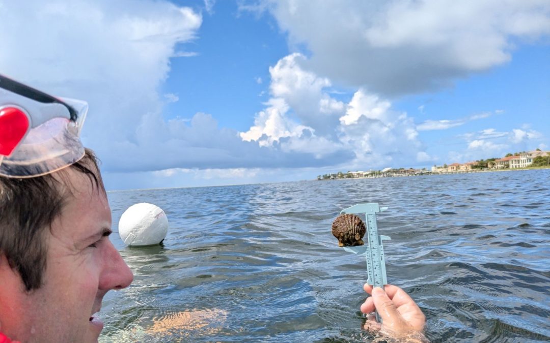
Once on site the volunteers extend a 50-meter transect line that is weighted on each end. Also attached is a white buoy to mark the end of the line. The two snorkelers survey the length of the transect, one on each side, using a 1-meter PVC pipe to determine where the area of the transect ends. This transect thus covers 100m2. The surveyors record the number of live scallops they find within this area, measure the height of the first five found in millimeters using a small caliper, which species of seagrass are within the transect, the percent coverage of the seagrass, whether macroalgae are present or not, and any other notes of interest – such as the presence of scallop shells or scallop predators (such as conchs and blue crabs). Three more transects are conducted within the grid before returning.
The Pensacola Scallop Search occurs during the month of July.
2024 Results
A record 168 volunteers surveyed 15 of the 66 1-nautical mile grids (23%) between Big Lagoon State Park and Navarre Beach. 152 transects (15,200m2) were surveyed logging 133 scallops. An additional 50 scallops were found outside the official transect for a total of 183 scallops for 2024.
2024 Big Lagoon Results
75 volunteers surveyed 7 of the 11 grids (64%) within the Big Lagoon. 67 transects were conducted covering 6,700m2.

101 scallops were logged with an additional 42 found outside the official transects. This equates to 3.02 scallops/200m2. Scallop searchers reported blue crabs and conchs, both scallop predators, as well as some sea urchins. All three species of seagrass were found (Thalassia, Halodule, and Syringodium). Seagrass densities ranged from 5-100%. Macroalgae was present in six of the seven grids (86%) but was never abundant.
2024 Santa Rosa Sound Results
93 volunteers surveyed 8 of the 55 grids (14%) in Santa Rosa Sound. 85 transects were conducted covering 8,500m2.
32 scallops were logged with an additional 8 found outside the official transects. This equates to 0.76 scallops/200m2. Scallop searchers reported blue crabs, conchs, and sand dollars. All three species of seagrass were found. Seagrass densities ranged from 50-100%. Macroalgae was present in five of the eight grids (62%) and was abundant in grids surveyed on the eastern end of the survey area.
2015 – 2024 Big Lagoon Results
| Year |
No. of Transects |
No. of Scallops |
Scallops/200m2 |
| 2015 |
33 |
0 |
0.00 |
| 2016 |
47 |
0 |
0.00 |
| 2017 |
16 |
0 |
0.00 |
| 2018 |
28 |
0 |
0.00 |
| 2019 |
17 |
0 |
0.00 |
| 2020 |
16 |
1 |
0.12 |
| 2021 |
18 |
0 |
0.00 |
| 2022 |
38 |
0 |
0.00 |
| 2023 |
43 |
2 |
0.09 |
| 2024 |
67 |
101 |
3.02 |
| Big Lagoon Overall |
323 |
104 |
0.64 |
2015 – 2024 Santa Rosa Sound Results
| Year |
No. of Transects |
No. of Scallops |
Scallops/200m2 |
| 2015 |
01 |
0 |
0.00 |
| 2016 |
01 |
0 |
0.00 |
| 2017 |
01 |
0 |
0.00 |
| 2018 |
01 |
0 |
0.00 |
| 2019 |
01 |
0 |
0.00 |
| 2020 |
01 |
0 |
0.00 |
| 2021 |
20 |
0 |
0.00 |
| 2022 |
40 |
2 |
0.11 |
| 2023 |
28 |
2 |
0.14 |
| 2024 |
85 |
32 |
0.76 |
| Santa Rosa Sound Overall |
1731 |
36 |
0.42 |
1 Transects were conducted during these years but data for Santa Rosa Sound was logged by an intern with the Santa Rosa County Extension Office and is currently unavailable.
Discussion
Based on a Florida Fish and Wildlife Research Institute publication in 2018, the final criteria are used to classify scallop populations in Florida.
| Scallop Population / 200m2 |
Classification |
| 0-2 |
Collapsed |
| 2-20 |
Vulnerable |
| 20-200 |
Stable |
Based on this, over the last nine years we have surveyed, the populations in lower Pensacola Bay are still collapsed. However, you will notice that in 2024 the population in Big Lagoon moved from collapsed to vulnerable for this year alone.
There are some possible explanations for this.
- The survey effort in Big Lagoon was stronger than Santa Rosa Sound. 75 volunteers surveyed 7 of the 11 grids. This equates to 11 volunteers / grid surveyed and 64% of the survey area was covered. With Santa Rosa Sound there were 93 volunteers who surveyed 8 of the 55 grids. This equates to 12 volunteers / grid surveyed but only 14% of the survey area was covered. Most of the SRS grids surveyed were in the Gulf Breeze/Pensacola Beach area. More effort east of Big Sabine may yield more scallops found.
- There is the possibility of different teams counting the same scallops. Each grid is 1-nautical mile, so the probability of one team laying their transect over an area another team did is low, but not zero.
- It is known that scallops have periodic population booms. Our search this year may have witnessed this. We will know if encounters significantly decrease in 2025.
Whether there was double counting this year or not, the frequency of encounter was much higher than in previous years. There were multiple reports from the public on social media about scallop encounters as well, and in some places we did not survey. It is also understood that scallops mass spawn. So, high density populations are required for reproductive success. The “boom” we witnessed this year suggests that there is a population of scallops – albeit a collapsed one – in our bay. It is important for locals NOT to harvest scallops from either body of water. First, it is illegal. Second, any chance of recovering this lost population will be lost if the adult population densities are not high enough for reproductive success.
Acknowledgements
We would like to thank ALL 168 volunteers who surveyed this year. We obviously could not have done this without you.
Below are the “team captains”.
Harbor Amiss Glen Grant Eric Stone
David Anderson Phil Harter Neil Tucker
Laura Baker Gina Hertz Christian Wagley
Melinda Bennett Sean Hickey Jaden Wielhouwer
Samantha Bergeron (USM class) John Imhof Keith Wilkins
Cheri Bone Jason Mellos Christy Woodring
Cindi Cagle Greg Patterson
Cher Clary Kelly Rysula

A team of scallop searchers celebrates after finding a few scallops in Pensacola Bay.
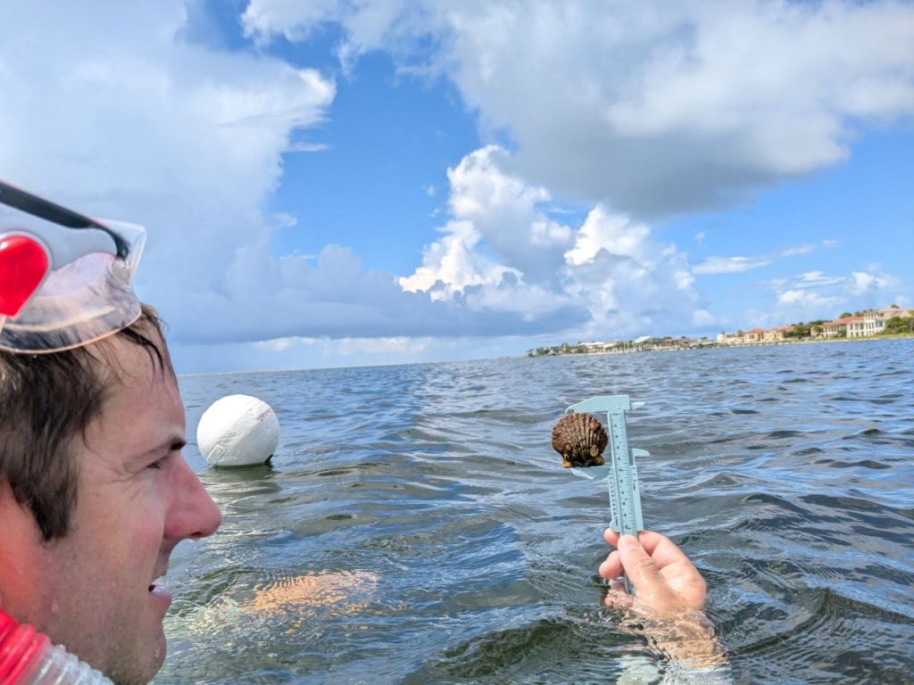
Volunteer measures a scallop he found. Photo: Abby Nonnenmacher
Rick O’Connor Florida Sea Grant; Escambia County
Thomas Derbes II Florida Sea Grant; Santa Rosa County
by Rick O'Connor | Aug 23, 2024
Roundworms differ from flatworms in that… well… they are round. You might recall from Part 1 of this series that flatworms were flat which helps with exchange of materials inside and out of the body. Flatworms were acoelomates – they lack an interior body cavity and thus lack internal organs. So, gas exchange (etc.) must occur through the skin. And a flat body increases the surface area in order to do this more efficiently.
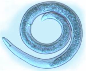
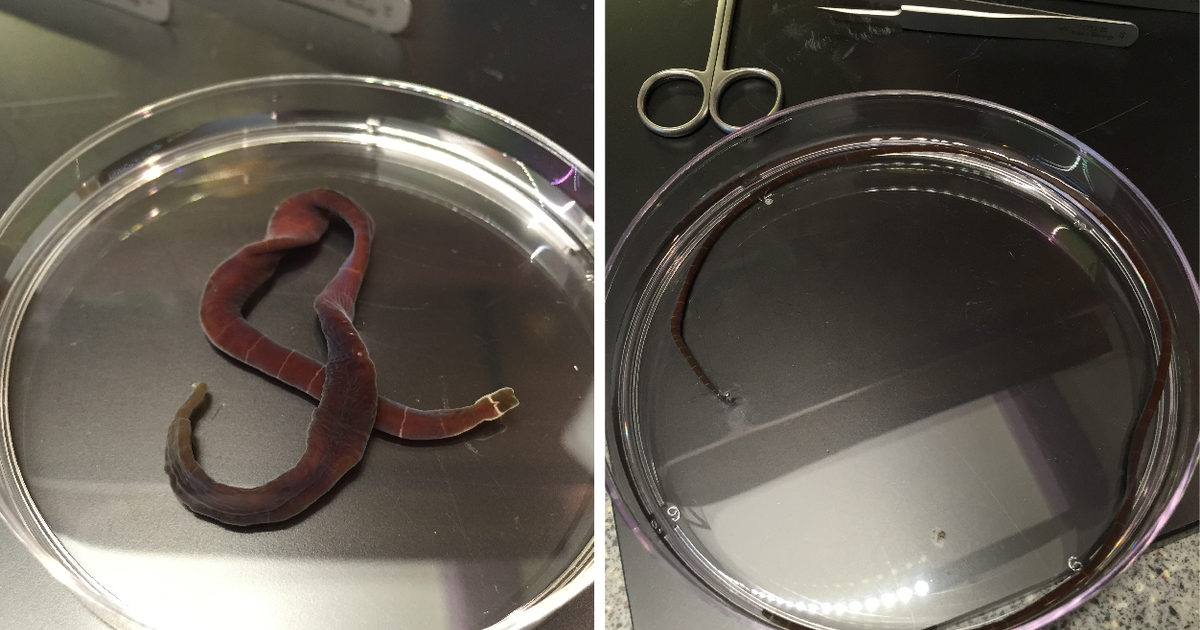
A common nematode.
Photo: University of Florida
But roundworms are round, which reduces this surface area and reduces the efficiency of material exchange through the skin. Though gas exchange through the skin does happen, it is not as efficient. So, there is the need for internal organs and that means there is a need for an internal body cavity to hold these organs. But with the roundworms there is only a partial cavity, not a complete one, and the term pseudocoelomate is used for them. Though the round body has adaptations to deal with gas exchange, it is a better shape for burrowing in the soil and sediment.
There are about 25,000 described species of roundworms, though some estimate there may be at least 500,000. They are placed in the Phylum Nematoda and are often called nematodes. Nematodes live within the interstitial spaces of soil, sediment, and benthic plant communities. They have been found in the polar regions, the tropics, the bottom of the sea, and in deserts – they are everywhere. They are usually in high numbers. One square meter of mud from a beach in Holland had over 4,000,000 nematodes. Scientists have estimated that an acre of farmland may have at least 1 billion of them. A decomposing apple on the ground in an orchard had about 90,000 nematodes. So, they are found everywhere and usually in great abundance. There are parasitic forms as well and they attack almost all groups of plants and animals. Food crops, livestock, and humans have made this group of nematodes a concern in our society.
Like many pseudocoelomates, nematodes have an anterior end with a mouth, but no distinct head – rather two tapered ends. Most of the free-living nematodes are less than 3mm (0.1in), but some soil nematodes can reach lengths of 7mm (0.3in) and there are marine nematodes that can reach 5cm (2in.) – it is a group of small worms.
Roundworms usually need water in order to move, even the soil species. They typically wriggle and undulate, similar to a snake, when moving and under a microscope they wriggle quite fast. In aquatic habitats they may swim for a short distance, and a few terrestrial species can crawl through dry sand.
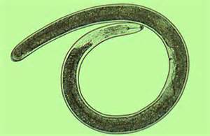
Marine Nematode – Dr. Roy P. E. Yanong, UF/IFAS Tropical Aquaculture Lab
Many free-living nematodes are carnivorous and feed on tiny animals and other nematodes. Some feed on microscopic algae and fungi. Some terrestrial species pierce the roots of plants and digest the material within. Many marine species will feed on detritus lying on the seafloor. The carnivorous species may possess small teeth, and many have a stylet they can use to pierce prey or the plant root to access food. The mouth leads to a long digestive tract and eventually an anus – nematodes have a complete digestive tract.
The brain is basically a nerve ring near the head that leads to numerous nerve chords that run the length of the body. Sensory cells are most associated with the sense of touch and smell.
Having separate sexes is the rule for nematodes, but not for all. Males are usually much smaller and usually have a hooked posterior end which they use to hold the female during mating. 50-100 eggs are usually produced and laid within the environment.
Farmers and horticulturists are familiar with these free-living nematodes, but it is the parasitic ones that are most known to the general public. There are many different forms of parasitism within nematodes. Dr. L.H. Hyman categorized them as follows:
- Ectoparasites that feed on the external cells of plants – using their stylet to pierce the plant tissue and remove nutrients.
- Endoparasites of plants. Juveniles of some nematodes enter plants and feed on tissue. This can cause tissue death and gall-like structures.
- Some free-living nematodes, while juveniles, will enter the bodies of invertebrates and feed on the tissue when the invertebrate dies.
- Endoparasites within invertebrates as juveniles, but the adult stage is free-living.
- Some are plant parasites as juveniles and animal parasites as adults. The females live within the bodies of plant eating insects, where they give birth to their young. When the insects pierce the plant tissue, the juveniles enter the plant and begin feeding on it. When they mature into adults, they re-enter the insects and the cycle begins again.
- Those that live within animals. The eggs, or newly hatched young, may be free-living for a short period, where they find new animal hosts, but the majority of the life cycle occurs within the animal. Many known to us infect dogs, cats, pigs, cattle, horses, chickens, fish, and humans.
Heartworms, pinworms, and hook worms are names you may have heard. For dog nematodes, the eggs are released into the environment by the dog’s feces. Another dog eats this feces and becomes infected.
The nematode known as Ascaris lumbricoides is the most common parasitic worm in humans. It has been estimated that almost 1 billion people are infected with it. Female Ascaris release developing eggs into the environment via human feces. Other humans become infected after swallowing food or water containing the eggs. Once inside the human, the eggs hatch and penetrate the tissue moving into the heart and eventually the lungs. From here they crawl up the trachea inducing a coughing response which is followed by a swallowing response that moves the developing juvenile worm into the esophagus and eventually back to the intestines where the cycle begins again. Infections of this worm are more common where sanitation systems are not adequate and/or human feces are used as a fertilizer.
Hookworms are another human parasite that feed on blood and can cause serious infections in humans due to blood and tissue loss. Fertilized eggs of this worm are laid in the environment and re-enter new human host as developing juveniles by penetrating their skin. Once in the new host the developing worms are carried to the lungs via the circulatory system and work their way into the pharynx, are swallowed, and eventually end up in the intestine. Not all hookworm juveniles penetrate through the skin but rather enter the body when the person unknowingly consumes human feces. This can happen from not washing your hands or food (if human waste is used as fertilizer). Pinworms and whipworms are other nematodes that have similar life cycles. In Asia there are some nematodes that are passed to humans by biting insects.
The roundworm known as the nematode is a common issue for farmers, horticulturists, and as a parasite in some parts of the world. Their lifestyles, while being a potential problem for us, have been very successful for them. In the next edition in this series, we will learn more about the most advanced worms on our planet – the segmented worms. We will begin with the polychaetes.
References
Barnes, R.D. (1980). Invertebrate Zoology. Saunders Publishing. Philadelphia PA. pp. 1089.
Ascaris lumbricoides. 2024. Wikipedia. https://en.wikipedia.org/wiki/Ascaris_lumbricoides.
by Rick O'Connor | Aug 10, 2024
I bet that for most of you, this is not only a worm you have never seen – it is a worm you have never heard of before. I learned about them first in college, which was almost 50 years ago, and have never seen one. But, other than the earthworm, the world of worms is basically hidden from us.
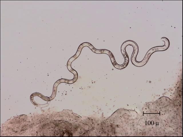
A nemertean worm.
Photo: Okinawa Institute of Science
Nemerteans are a group of about 1300 species in the Phylum Nemertea and are often called ribbon or proboscis worms. They do possess a proboscis used to capture prey. Most are marine and live on the bottom both near the beach and a great depth. They are more temperate than tropical and do have a few parasitic forms.
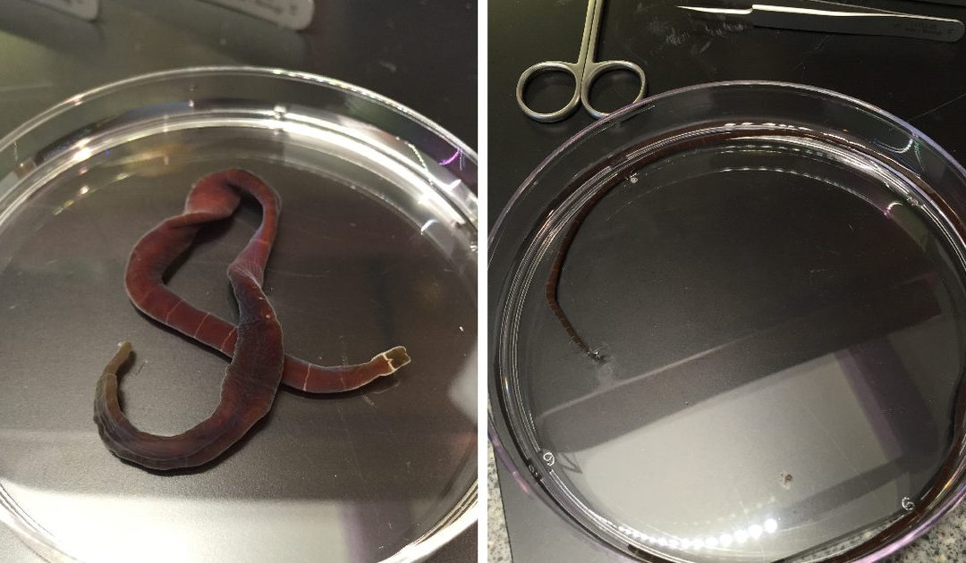
Adult Nemertea Worms – Terra C. Hiebert, PhD, Oregon University
In appearance they resemble flatworms but are larger and more elongated. Most are less than 20cm (8in) but some species along the Atlantic coast can reach 2m (7ft). The head end can be lobed or even spatula looking. Some species are pale in color and others quite colorful. Most nemerteans move over the substrate on a trail of slime produced by their skin. Some species can swim.
As mentioned, the proboscis is used to capture prey. It is a tube-like structure held in a sac near the head. When prey is detected, they can launch the proboscis out and over the victim. Sticky secretions help hold on to the prey while they ingest. Many species are armed with a stylet, dart, that is attached to the proboscis and is driven into the prey like a spear. From there toxins, secreted from the base of the proboscis are injected into the prey.
For many species the proboscis is connected to the digestive tract via a tube, there is no true mouth, but they do possess an anus. They are all carnivorous and feed on a variety of small living and dead invertebrates. Their menu includes annelid worms, mollusk, and crustaceans.
Nemerteans do possess a brain and most find their prey using chemoreception, though some species must literally bump into their prey to find it. They have multiple eyes that can detect light, and, like the true flatworms, they are negatively phototaxic. They are nocturnal by habitat and is probably why most of us have never seen one.
Many nemerteans, particularly the larger ones, have a habit of fragmenting when irritated, creating new worms. Most species have separate sexes and fertilization of the gametes is external (fertilization occurs in the environment).
Nemerteans are an interesting group of semi-large, sometimes toxic, hunters who prowl through the marine waters at night hunting prey. Seen by few, maybe one evening, while exploring or floundering, you may see one.
In Part 3 we will begin to explore a group of worms that are more round than flat. The Gastrotrichs.
Reference
Barnes, R.D. (1980). Invertebrate Zoology. Saunders Publishing. Philadelphia PA. pp. 1089.
by Rick O'Connor | Aug 10, 2024
I was recently conducting a survey for diamondback terrapins from my paddleboard in a small estuarine lagoon within the Pensacola Bay System. Even if we do not find our target species during these surveys – I, and our volunteers, see all sorts of other cool wildlife. On this trip I was treated to nesting osprey, a kingfisher, large blue crabs, and even a swimming eel. But one neat encounter was the numerous stingrays.
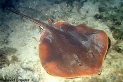
The Atlantic Stingray is one of the common members of the ray group who does possess a venomous spine.
Photo: Florida Museum of Natural History
They were lying in the sand and grassbeds, lots of them, and they all seemed to be of one species – the Atlantic stingray. My brain immediately went to “breeding season”, but when I checked the literature, I found that it was not breeding season, but pupping season – the babies were being born.
Atlantic Stingray (Dasyatis sabina) are true stingrays in the family Dasyatidae. This means they do possess the replaceable serrated venomous barb that makes these animals so famous. They are one of the smaller members of this family. Females can reach a disk width of two feet while the smaller males will only reach about one foot. Atlantic stingrays are a warm water species, migrating if they need to find suitable temperatures. They have been found in water as deep as 80 feet but are more common in the warmer shallower waters near shore. They are very common in our estuaries and being euryhaline (they tolerate a large range of salinity), are found in freshwater systems. There is a population that lives in the St. Johns River. Atlantic stingrays feed on a variety of benthic invertebrates and have special cells in the nose to detect the weak electric fields their prey give off while buried in the sediment. They also like to bury in the sand to ambush prey as they move by.
Breeding occurs in the fall. The smaller males possess two modified fins called claspers connected to their anal fins that are used to transfer sperm to the female. The males have modified teeth they can use to bite the fins of the females. They do this to hold on and make sperm transfer more successful.
The females do not begin to ovulate until spring. So, though they receive the sperm in the fall, fertilization does not occur until the spring. Instead of laying eggs, as some rays and skates do, baby Atlantic stingrays develop within the mother. This is not the same as mammals, who produce a placental to feed the developing young, but more like an internal egg with no hard shell. The embryo is attached to, and feeds from, a yolk sac. Gestation takes about 60 days at which time the yolk sac is depleted, and the young must emerge. Birth usually occurs in late July and early August, and each female will produce 1-4 small pups whose disk are about 10cm (4in.) wide. It was this birthing/pupping period I witnessed.
I returned the following day to search for terrapins and the number of stingrays was significantly fewer. It may be that the birthing process is fast, and the adults leave the coves afterwards. It may have been because that day was the day Hurricane Debby was making landfall east of us and the water levels were abnormally high – something the rays may have noticed and decided to leave – I am not sure.
I was really hoping to see the young rays swimming around – I did not – but plan to search again soon. Stingrays make many people nervous. I witnessed several adult rays whose tails had been cut off – which is very unfortunate – but they are actually cool creatures and fun to watch while paddleboarding. Maybe I will see a baby soon.
References
Dasyatis sabina. 2023. Florida Museum of Natural History. https://www.floridamuseum.ufl.edu/discover-fish/species-profiles/dasyatis-sabina/.
Johnson, M.R., Snelson Jr., F.F. 1996. Reproductive Life History of the Atlantic Stingray, Dasyatis sabina (Pisces, Dasyatidae), in Freshwater St. Johns River, Florida. Bulletin of Marine Science, 59(1): 74-88.

