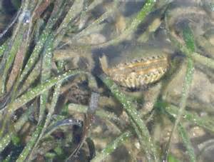
Since 2007 Florida Sea Grant has worked with partners, and trained volunteers, to assess the status of the diamondback terrapin in the Florida panhandle. This small emydid turtle is the only one that lives in brackish water and prefers salt marshes. Very little is known about this turtle in this part of the country, and the Panhandle Terrapin Project has the goal of changing that.
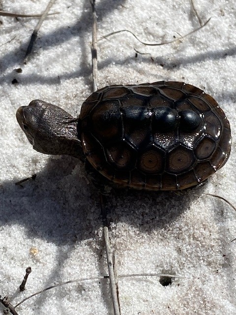
Female diamondback terrapin.
Photo: Rick O’Connor
Terrapins have strong site fidelity, meaning they do not roam much, and spend most of their day basking in the sun and feeding on shellfish – marsh snails being a particular favorite. Like many species of turtle, they breed in the spring. Gravid females leave the marsh seeking high dry sandy beaches along the shores of the estuary to lay their eggs. Unlike sea turtles, she prefers to do this on sunny days – the sunnier the better. She typically lays between 7-10 eggs, and they hatch in about two months. The hatchlings spend their early months on shore, hiding under wrack and debris feeding on small invertebrates before heading to the marsh where the cycle begins again.
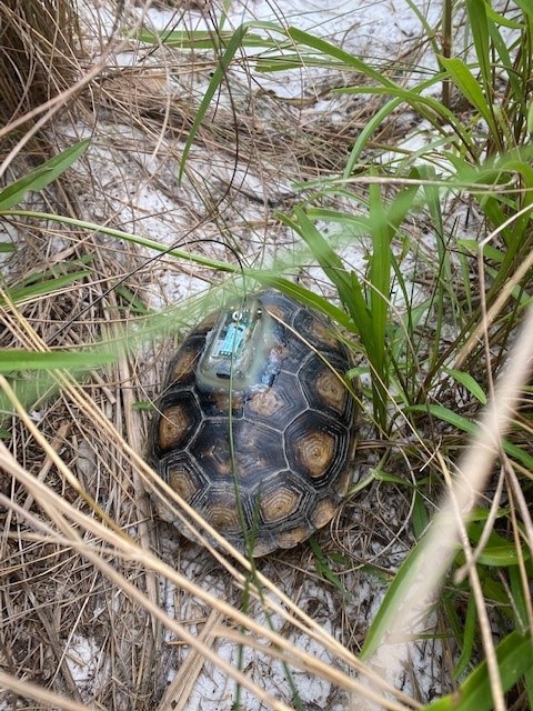
The project has three objectives each year. One, to survey known (primary) nesting beaches for nesting activity. The number of nests, tracks, and depredated nests can be used to calculate a relative abundance of these animals using those beaches. Two, survey potential (secondary) nesting beaches for any presence of nesting activity. Three, tag terrapins using the old notch method, PIT tags, and a small few with satellite tags. This will help us track terrapin movement and better understand how they use the habitat.
Since the project began, we have been able to verify at least one terrapin in each of the seven panhandle counties being surveyed and have identified nesting beaches in four of those. Relative abundance is rather low when compared to other regions within their range, but those beaches remain active.
The nesting season historically begins in late April and 2023 has been busy early. Seven hatchlings that overwintered in their 2022 nests emerged and were found by volunteers, and others. Two depredated nests were located, and one nesting female was captured and tagged. The volunteers will continue to survey the rest of the spring and much of the summer. Reports of these turtles are important in our assessment. If you believe you have seen a terrapin, contact Rick O’Connor – roc1@ufl.edu – (850) 475-5230 ext.1111. and let us know where.
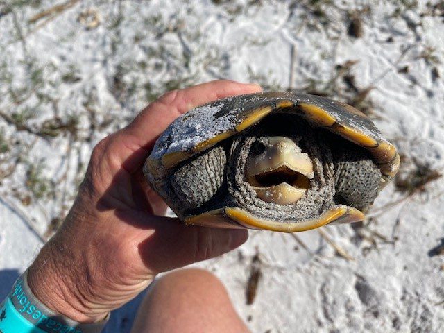
Female terrapin fixed with a satellite tag for tracking.
Photo: Rick O’ConnorSmall terrapin hatchling released on Santa Rosa Island.
Photo: Rick O’Connor
This sounds similar to the idea that has been discussed about protecting some species of sharks. Do we really want to do this?
It reminds me of an interesting situation that was created when they passed the Marine Mammal Act in 1972. The law seemed simple enough. Citizens wanted to protect our marine mammals – such as whales, dolphins, and manatees. But it also included the polar bear, a dangerous animal. If you lived in a community where polar bears existed, and had one enter town that could possibly be a threat to the citizens, could you shoot it? A colleague of mine had a brother who worked with Alaska Fish and Game. We asked this question. He told us that – yes, if you were threatened by one you would shoot it. But you would have to defend yourself in court that it was defense and that you were not actively hunting the bear.
It seems odd to some that we would even consider protecting a creature that is potentially lethal to humans. But, as has been said so many times before, though they are potentially lethal, they rarely are. Rattlesnakes are different from polar bears in they do not seek us out when they are near us. They actually try to avoid us. In the United States only 5-6 people die each year from venomous snakes bites1. Comparing this to the number who die in car accidents, gun violence, or opioid overdose, there is no comparison. So, though the potential is there it is a very low risk. We can also note that many who bitten by snakes were trying to catch or kill the animal.
On the other side of the coin, these animals do us a service by controlling disease caring rodents. When predators select and kill prey, they tend to select one that is easy to catch and kill. Most predators not only have teeth, but hands and claws to grab the prey. The only thing a snake can do when it sees a rodent is grab it with its mouth and hold on. Many snakes do this, almost 90% of those in Florida do. But a few have venom. This can be injected into the prey so that the snake does not have to hold on, making the process much easier. It makes sense for snakes to have venom and is surprising that more do not. However, this venom was meant for killing prey, not for defending against predators. And rattlesnakes, like other venomous snakes, do not want to use it on humans if they can avoid it. As my professor told us in college venom is “expensive”. It is a complex cocktail of proteins they must produce, and they do not want to waste it.
So, though it seems strange that a state or federal agency would even consider protecting dangerous animals, they do. These creatures play a vital role in the ecology of local systems and if their numbers decline that role is not filled and the spin-off results could have larger negative impacts on us.
The U.S. Fish Wildlife Service has been petitioned to list the eastern diamondback rattlesnake (Crotalus adamanteus). This animal inhabits several habitats within the coastal southeastern United States. The National Council of Air & Stream Improvement, Inc. – a scientific research organization that provides technical information on environmental issues concerning forestry and forestry products – is conducting a survey to better understand its distribution and habitat preferences. They are asking people to report sightings of this snake. You can do so by visiting the following link. Please take photos.
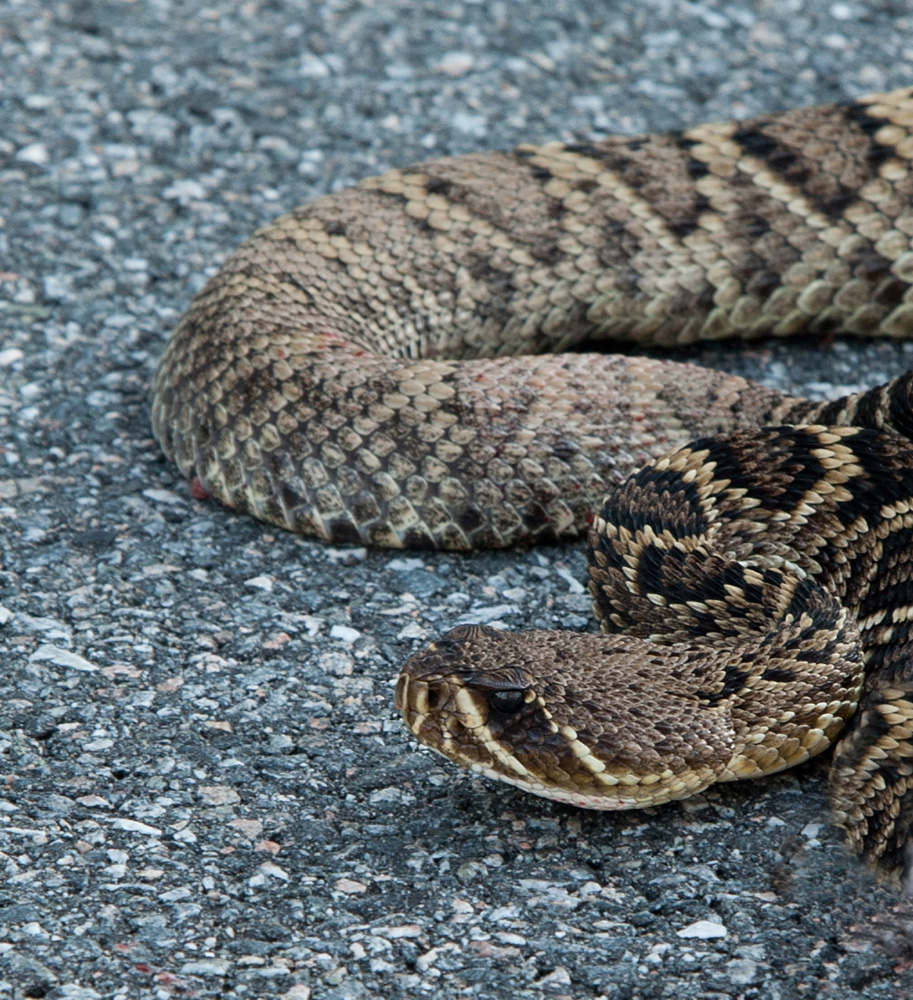
The eastern diamondback rattlesnake is a classic serpent found in xeric habitats like barrier islands and deserts. They can be found in all habitats on barrier islands.
Photo: Bob Pitts
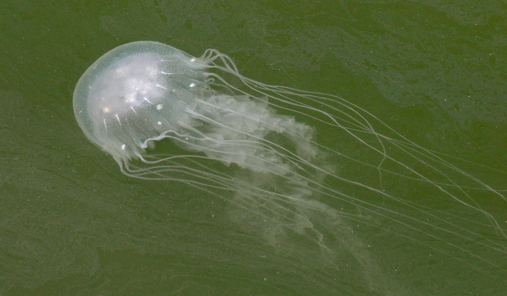
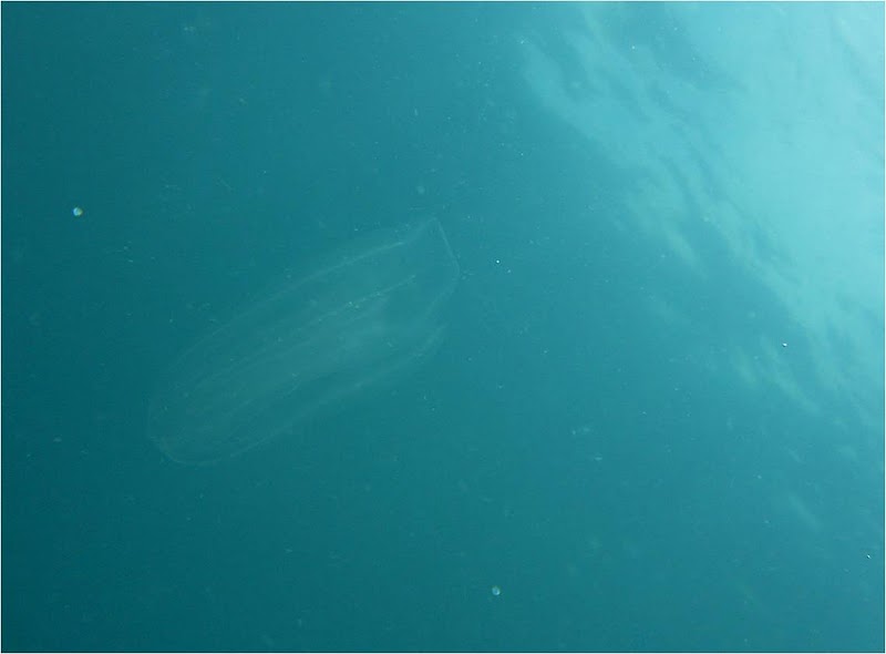
The word “jellyfish” tends to initiate a similar response in most people – “scream”, “run”, “this is going to hurt”. Being stung by a jellyfish is not pleasant and is something most would prefer to avoid. Our beaches warn us when they are out by flying a purple flag.
When exploring the seagrasses, this is not the first animal people thing they will encounter. Few associate jellyfish with the seagrass community. But within any community there are those we call residents (they reside here) and those we call transients (just passing through). It is the second group that we can place most jellyfish, at least the ones we are concerned about.
The sea nettle.
Photo: University of California at Berkley.
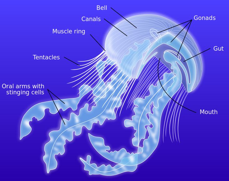
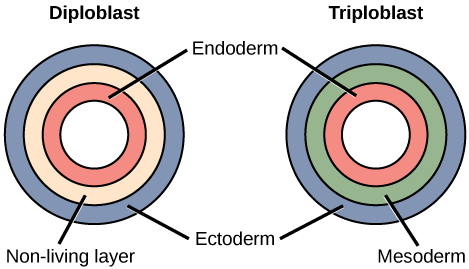
Jellyfish are animals, but not your typical ones. They are obviously invertebrates but differ from most others by having radial symmetry (having a distinct top and bottom, but no head nor tail). They possess ectoderm and endoderm (so, they have a skin layer and some internal organs) but they lack the mesoderm that generates systems such as the skeletal, circulatory, and endocrine. Though they do not have a brain, they do have a simple nervous system made up of basic neurons and some packets of nerve cells called ganglia. They seem to know when they are not in the upright position and know when they have stung something – which initiates the feeding behavior. But they are pretty basic creatures.
When you view a jellyfish the first thing you see is the “bell” and the tentacles – we always see the tentacles. The bell is usually round (radial), could be bell-shaped, or could be flat. It is made of a flexible plastic-like jelly material called mesoglea. Most of the mesoglea is actually water. When you place most jellyfish on the dock and come back in a few hours there may be nothing but a “stain” of where it was. It completely evaporated. There are some exceptions to this, like the moon jelly and the cannonball jelly, who leave thick masses of mesoglea for long periods of time.
Image: Wikipedia.
If you look closer at the “bell” you will see shapes within the mesoglea. Some are stripes, and may have color to them, others look like a clover leaf. These are the gonads of the animal. Jellyfish are hermaphroditic (the gonads can produce both sperm and egg), and they reproduce by releasing their gametes into the water column when triggered by some environmental clue to do so.
Around the edge of the “bell” many have a thin piece of tissue called the velum that can undulate back and forth and allow the jellyfish to swim. Swimming can involve moving up or down in the water column, or turning around, but the swimming action is not very strong and the tide and current actually plays a larger role in where the animals go – like pushing them through a seagrass bed.
Under the “bell” is a single opening, the mouth, that leads into a simple gut (the gastrovascular cavity). This serves as the stomach of the creature. But there is no anus, when the jellyfish has digested its food, the waste is expelled through the same opening – the mouth. This is called an incomplete digestive system.
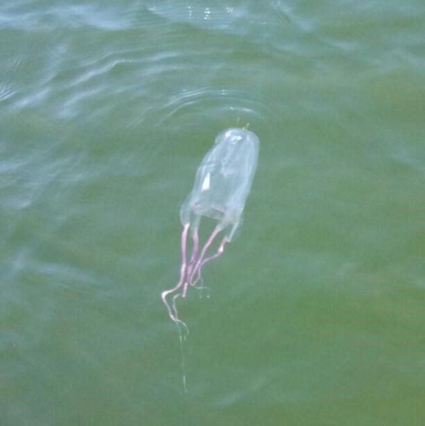
Jellyfish are predators and hunt small creatures such as baitfish. Though they know whether they are upside down or not, and may be able to detect light, most have no true eyes and cannot see their prey. Some species may be able to detect scent in the water and undulate their velum to try and move towards potential food, but most drift in the water and hope the tide carries them to dinner. To kill their prey, they extend tentacles into the water. These tentacles are armed with stinging cells known as nematocysts. Each nematocyst holds a coiled harpoon with a drop of venom at the tip. They are encased in a cell membrane and are triggered when an object, hopefully food, bumps an external trigger hair that will fire the harpoon. This will then trigger the release of many nematocysts and the potential prey will be “stung” by many drops of venom. The venom can either kill or paralyze the prey at which time the tentacles bring it to the mouth. Many jellyfish have venom that is painful to humans, like the sea nettle and moon jelly, others have a mild venom that we do not even notice. Some have a very strong venom and can be quite painful, like the Portuguese man-of-war which has put some in the hospital. The famous box jelly of Australia has actually killed humans. We do have box jellies in the Gulf of Mexico, but they are not the same species.
This box jellyfish was found near NAS Pensacola in November of 2015.
Photo: Brad Peterman
As the tide pushes these transients through the seagrass meadows, their tentacles are extended and small baitfish like juvenile pinfish, croakers, and snapper become prey. But there are resident jellyfish as well.
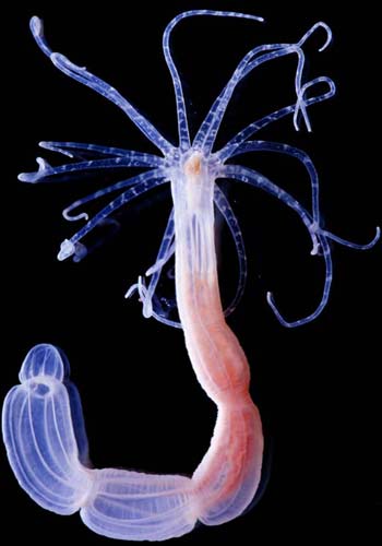
With the Phylum Cnidaria (the stinging jellyfish) there are three classes. Class Scyphozoa includes the bell-like jellyfish that drift in the water column with extended tentacles – what are referred to as medusa jellyfish. But there are two other classes that include benthic (bottom dwelling) jellyfish called polyps.
Polyp jellyfish resemble flowers. The “bell” part is a stalk that is stuck to a rock, pier, or seagrass blade. Their tentacles extend upwards into the water column giving the creature the look of a flower. Instead of drifting and dragging their tentacles, they hope to attract prey by looking like a hiding place or other habitat. The sea anemone is a famous one, and a good example of the polyp form. But it also includes corals and small polyps known as Hydra. Hydra are tiny polyps that are usually colorless and can easily attach to a blade of turtle grass. Here they extend their tentacles into the water column trying to paralyze small invertebrates that are swimming by or grazing on the epiphytes found on the grass blades.
The polyp known as Hydra.
Photo: Harvard University.
Another jellyfish that drifts in the current is Beroe, what some call the “football jellyfish” or “sea walnut”. This a relatively small blob of jelly that lacks tentacles but rather has eight rows of cilia/hair (ctenes) along its side that move quickly and move this animal through the water. But like their medusa cousins, not against the tide or current. These jellyfish do not sting, they lack nematocysts, and hence are in a different phylum known as Ctenophora. Kids often find and play with them when they are present, and they are luminescent at night. These stingless jellyfish feed on small plankton and each other and are another transient in the seagrass community.
The non stinging comb jelly.
Florida Sea Grant
There are certainly species of jellyfish to be aware of and avoid. But as you look deeper into this group there are harmless and fascinating members as well. Most of these Hydra are very small and hard to see while snorkeling, but they are there. Another creature to try and find while you are exploring and play “seagrass species bingo”. Have fun and stay safe.
Many who visit a seagrass bed for fishing or snorkeling, see many forms of marine life while there. There are numerous small silver fish darting in and out of the grass, an occasional stingray half buried in the sand waiting to ambush prey, and sometimes a horseshoe crab crawling along looking for a meal. One seagrass community creature they are not aware of, even if they are in front of them, are the sponges.
Those who are not familiar with the creature we call the sponge may think of the synthetic ones purchased at grocery stores and made in a factory somewhere. They are usually colored to match your kitchen or bathroom. Those who are familiar with them associate them more with reefs. Some reef sponges can become quite large and often they are quite numerous out there. But they do not register as a member of the seagrass community with most people. But they are out there.
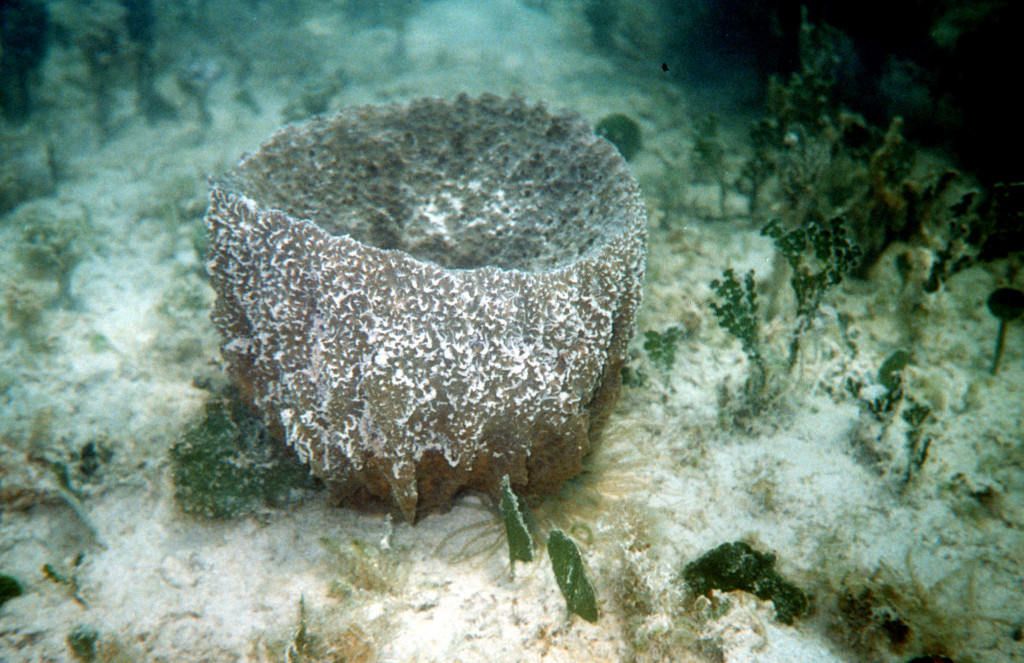
A vase sponge.
Florida Sea Grant
From a taxonomic point of view sponges are interesting. What is a sponge?
Is plant? animal? fungi?
Well, to classify it using the characteristics of each, we can rule out plants. Plants have cell walls and organelles within some cells to conduct photosynthesis. This is not the case for sponges.
We can also rule out fungi. Though fungi do not photosynthesize, they do have cell walls, and sponges do not.
This leaves animals. Yep… they are animals.
Once you classify it as an animal the next step is to declare it either a vertebrate or invertebrate. Based on the definition of each, this would be an invertebrate – there is no backbone.
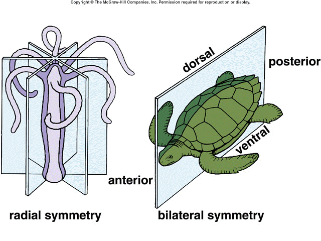
Invertebrates can be further broken down based on their symmetry and which germ layers they possess in the early stages of development – the larval stages.
Most invertebrates are categorized as either having radial or bilateral symmetry. Radial invertebrates have a top and bottom (dorsal and ventral) side, but no head or tail (anterior, posterior). Bilateral invertebrates will have all four. For some sponges, you can find radial symmetry, for others there is no symmetry at all – those would be asymmetrical.
Bilateral creatures have a distinct “head” end (anterior) and a “tail” end (posterior).
With germ layers you can have ectoderm (the outside cell layer), endoderm (the inside), and mesoderm (the middle layer). Each germ layer develops different structures as the larva grows. If the creature is does not have a specific germ layer, they will not develop those specific structures. Sponges have no germ layers. They do not have true skin, no internal organs, no circulatory, musculature, or nervous system. That is a sponge… the simplest form of animal life on the planet.
The three germ layers of animal development.
When you look at a sponge you do see structure. There are different forms (species) of them and they can be distinguished from each other and named – like “vase sponge”, or “barrel sponge”. But when you look inside of them many have a lot of tissue with canals and channels running all through them. Like what an ant colony would look like underground.
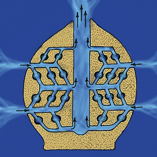
A closer look shows that the exterior wall is very porous (giving them their phylum name Porifera). The water enters these pores and moves all through the massive highways of channels running through the creature. Eventually the water exits the sponge at the top through large pores (or one large pore) called the osculum. The currents that drive this water movement are generated by the flagella of small cells called choanocytes (collar cells). They line the channels by the thousands. Rotating their flagella, they create water movement the way a rotating fan causes air movement. The movement is from the environment into the sponge. Here they collect food from the water (small microscopic creatures and other forms of organic debris), and oxygen.
The anatomy of a sponge.
Flickr
There are other cells within the lining of the channels called amoebocytes who assist with reproduction. They can encase genetic material (cells) within a hard matrix called a gemmule and “toss it” into the currents where it will exit through the osculum, drift in the ocean currents, and form a new sponge elsewhere. Being simple creatures, they can certainly reproduce asexual by simple cell division. Fragments of sponge will also generate new sponges.
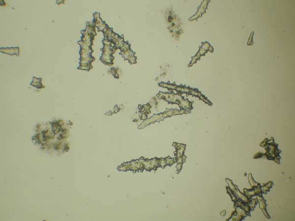
The skeleton that holds these cells into the form we see is a series of hard structures called spicules. Spicules come in different shapes and under the microscope appear to look like thorns, are the “jacks” of a common game played by baby-boomers when they were kids. Some are solid, others a little more flexible, and the material used to make these spicules are used to divide sponges into different classes.
Sponge spicules.
Image: NOAA
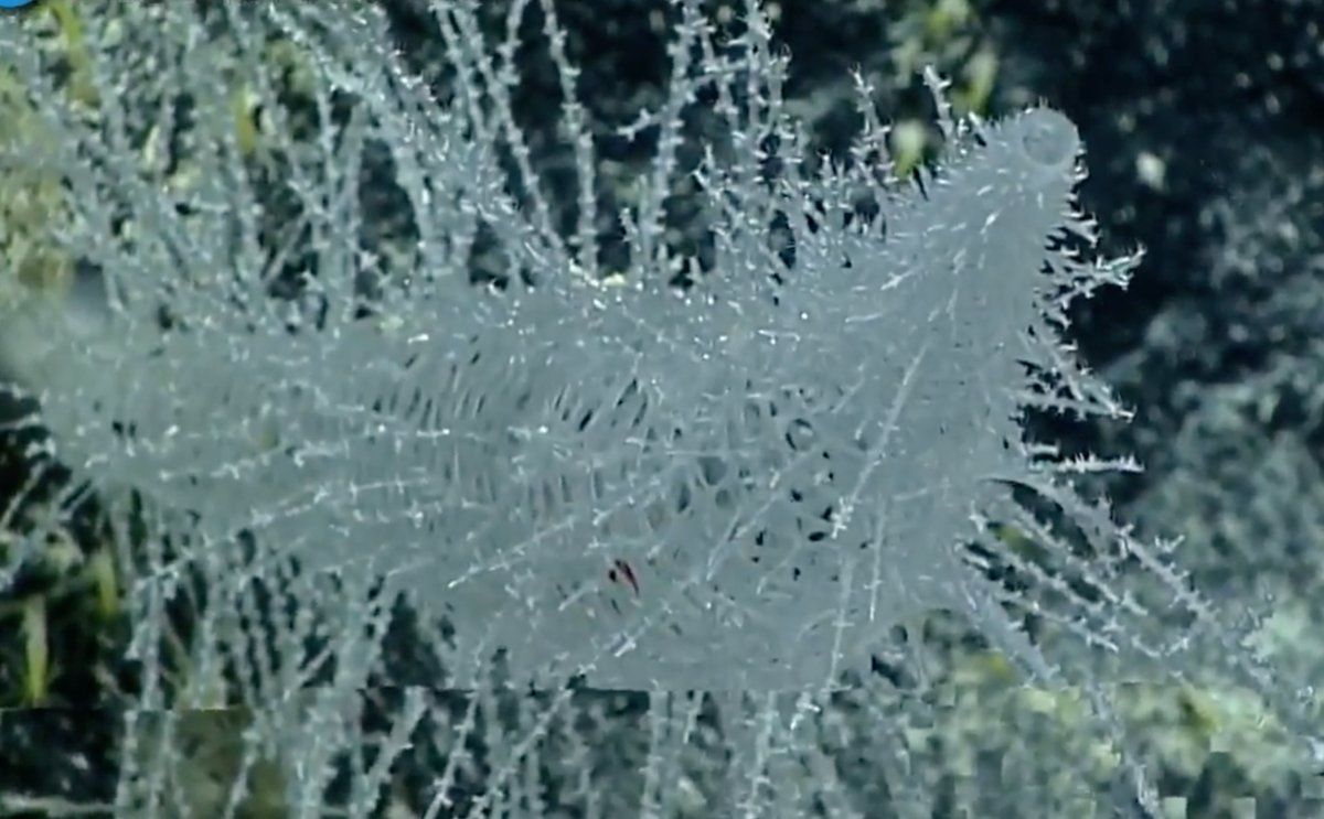
Spicules made from calcium carbonate are hard and scratchy, they are in the Class Calcarea. These are often sold as “luffa’s”. Those made of the more flexible-spongin are in the Class Demospongia and is the largest class of sponges. These are often sold as “bath sponges” and are softer. And then there is the Class Hexactinellida – the “glass sponges”. Their spicules are made of clear silica and they look like they are made of glass. They are more common in the deeper part of the ocean and are beautiful.
Glass sponges are beautiful.
Photo: NOAA
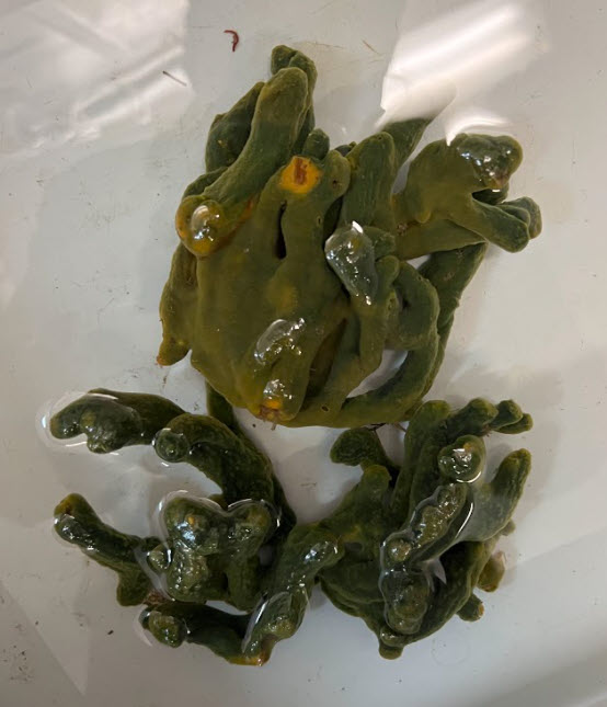
In the seagrass beds of the panhandle, you will find sponges from the “bath sponge” group. One common one sold at the Gulf Specimens Lab in Panacea is called “Green Finger Sponge”. As you move through the grasses you will encounter these anchored near the base of the grass. They are usually dark in color, often a dark green almost black, and when opened appear yellow or orange on the inside.
They are full of creatures. Sponge channels provide excellent hiding places for the small creatures who graze on the epiphytes found on the grass blades. All sorts of small crustaceans and worms can be found here. It is like a microhabitat within the grassbed system itself.
Green finger sponge common in panhandle grassbeds.
Photo: Gulf Specimens Lab
The relationship between sponge and grass is complicated. Sponges filter the water, improving water clarity which seagrasses need. However, seagrasses are excellent at trapping and holding sediment, which also improves water clarity but these same sediments can plug the pores of sponges which they need to feed. It is sort of a love/hate relationship between them.
The purpose of this series is to educate you on some of the members of the seagrass community. Sponges are one such creature and most people do not notice them. But they are interesting creatures if you take a look.
The open grasslands of the American west support huge herds of grazing herbivores such as bison, antelope, and deer. These large herds again support populations of hunters such as wolves, coyotes, and – historically – bears. The huge acres of wetland grasses we call marshes are productive as well, with all sorts of grazing creatures that feed on the grass like snails and insects, which in turn support populations of first order carnivores like birds, crabs, and turtles, who then feed larger predators like alligators, otters, and raccoons.
The salt marsh is full of life, if you look close enough. Photo: Rick O’Connor
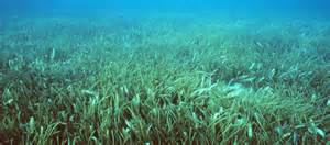
One would think that the submerged seagrass meadows would work in the same way. But there are no large herds of bison like creatures that graze on the grasses. True, manatees and sea turtles do graze on these, but not in the numbers we see with bison and antelope. There are numerous species of snails and crustaceans that live in seagrass, but it is not the grass they are interested in… it is the epibiota. These epibiota are the key to vast diversity of creatures living in seagrasses. If you snorkel or seine through a submerged grassbed you will notice the majority of creatures are small. This place is a nursery for the estuarine and marine environments. These grasses provide excellent hiding places and the epibiota provide the food they need to grow.
Grassbeds are also full of life, albeit small creatures.
Photo: Virginia Sea Grant
So, what are these epibiota?
The term epibiota means “creatures that live on other creatures”. They can be further broken down into epiphytes (plants that growth on other creatures), and epizoids (animals that grow on other creatures). Spanish moss is a familiar example of an epiphyte most people know. Barnacles growing on a turtle shell, or a whale could be an epizoid you are familiar with. Many epibiota are small, even microscopic. You can see the algae growing on the shells of turtles, or the fur of the sloth. There are also numerous epizoids that are microscopic, and no one sees. It is a whole field of microbiology – the study of the natural history and diversity of this tiny world that, certainly in the case of seagrasses, makes the whole thing work.
The wide blades of turtle grass provide habitat for a variety of epibiota.
Photo: UF IFAS
With the seagrasses you will not always see the epibiota we are talking about. At times, there are mats of algae growing on the grass like Spanish moss on oak trees. We typically see these epibiotic macroalgae growing on seagrasses in the spring and summer. Most of these algal mats are red algae. Studies have shown that they support juvenile animals as hiding habitat and can increase the overall biomass of seagrass meadows. But, like with all things, too much of a good thing can have a negative effect on seagrass meadows as well. The seaweed can smother the grasses, reducing needed sunlight, and enhance the decline of seagrasses in some areas.
Gracilaria is a common epiphytic red algae growing in our seagrass beds. Photo: Rick O’Connor
Most of the epibiota feeding the growing populations of shellfish and finfish using these nurseries are microscopic plants and animals that appear to us as “scum” on the blades of the grass. As you might expect, the wider the blade (in this case turtle grass) can support a higher diversity and abundance of growing grazers than the thinner shoal grass.
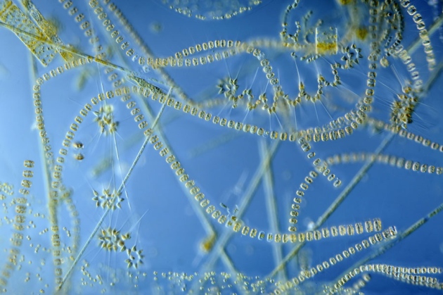
A study conducted in 1964 listed 113 species of microscopic algae existing on the blades of seagrasses in Florida. They include such creatures as diatoms, cynobacteria, and bryozoans. We will focus on these.
Diatoms are quite abundant on seagrass blades and provide for microscopic grazers.
Photo: University of New Hampshire
Diatoms are single celled plant-like algae that are encased in a clear silica shell. They are one of the most abundant forms of oxygen producing plant-like creatures found in the sea. Many species drift with the phytoplankton layers of the open ocean. Others are benthic, living on the bottom upon rocks, seawalls, turtle shells, and seagrasses. It has been stated that 50% of the oxygen produced on our plant comes from the diatoms and the dinoflagellates (another microscopic plankton).
Cells of a species of cyanobacteria.
Photo: Florida Atlantic University.
Cyanobacteria are what many call blue-green algae. They produce a darker colored green with their photosynthetic pigments – thus the name blue-green algae – but were not initially identified as a bacteria – which they are now because they lack an organized nucleus. Many have heard of the recent cyanobacteria blooms in central and south Florida in freshwater systems. Some species are toxic and have caused fish kills and even made pets, who drank from water with cynaobacteria, very sick. There hundreds of different species found in marine systems. Like diatoms, some live in the water column, others are attached to an object on the bottom – like seagrasses.
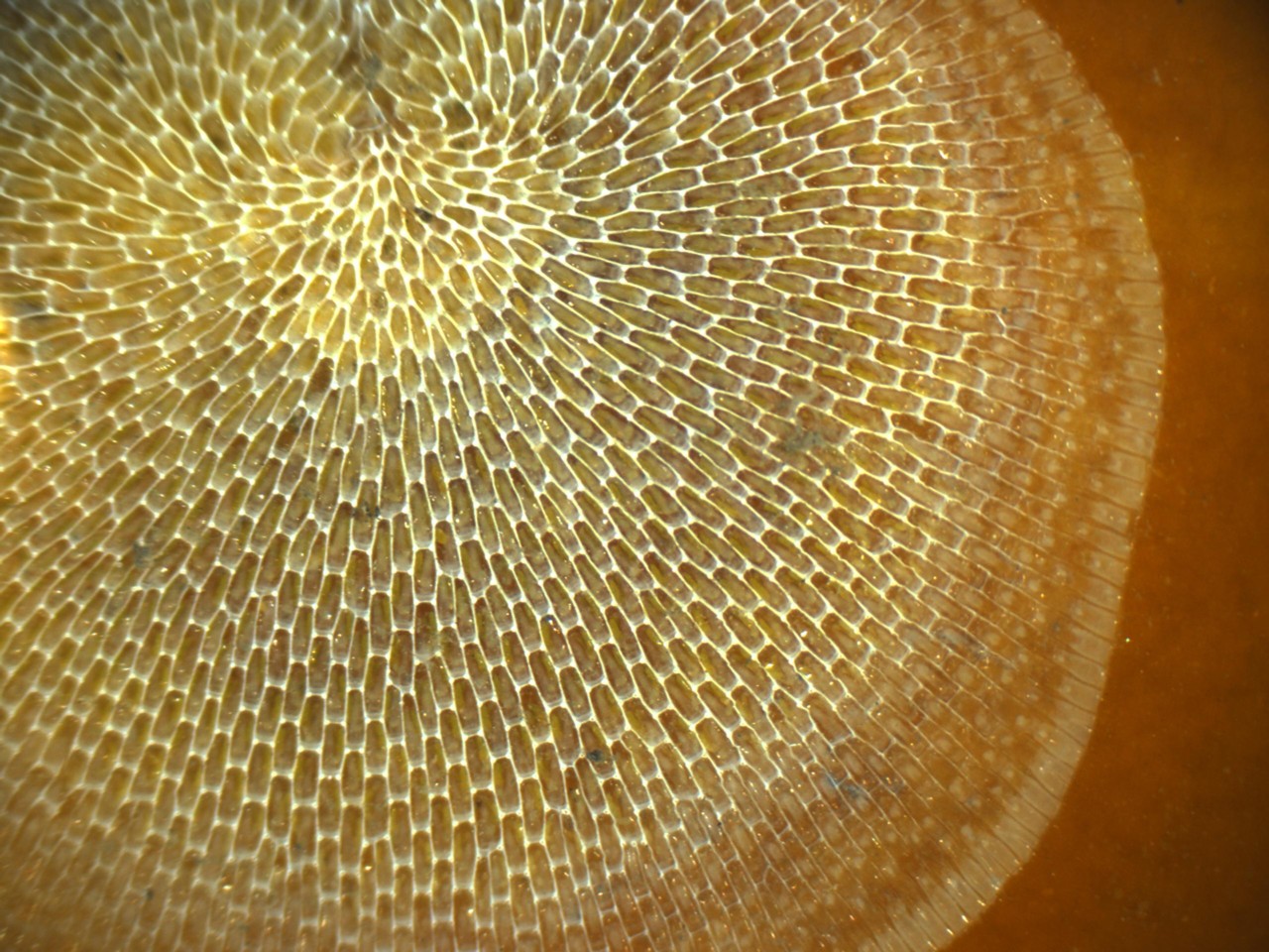
This beautiful matrix was built by a group of microscopic animals known as bryozoans.
Bryozoans are microscopic colonial animals. They act and behave similar to corals, though they are much smaller. Some species appear as a “cast net” over the shell of a snail or clam, and can be seen on blades of turtle grass as well. There are many other species of these colonial creatures that call seagrass home.
We are highlighting these three groups but there are many other forms of epiphytes and epizoids growing on these grass blades. And it is these that the small grazers, like tiny crustaceans, feed upon, which in turn are what the millions of small silver juvenile finfish and crabs are feeding on. The seagrass meadow biodiversity and productivity is dependent on them and most Panhandle folks do not know they are there. Dr. Edward O. Wilson made a comment in his book Half Earth, that we have been focused on conservation of wildlife and habitat for many years now – but we fully do not understand what it is we are trying to conserve. We focus on blue crab and manatee conservation and do not realize that conservation of these micro-communities is essential for conservation, or restoration, success. The first step in conserving such communities is knowing they exist and how they support the system. You now have a little more knowledge of them, but there is SO much more to learn.