by Sheila Dunning | Apr 18, 2019
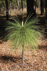
Young Longleaf Pine
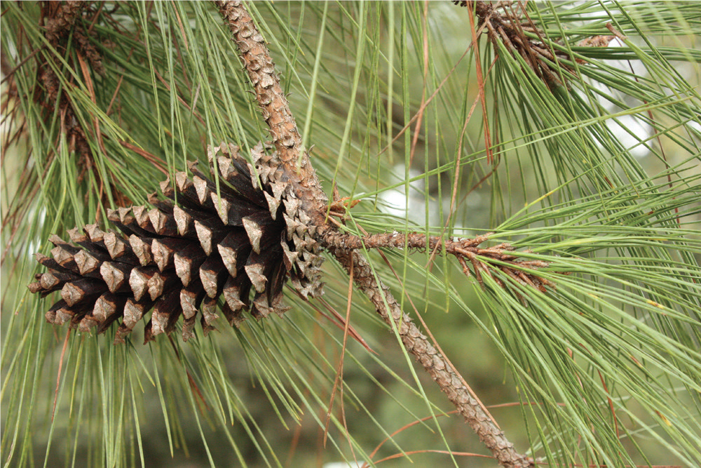
All of Florida’s ecosystems contain pine trees. There are seven native species in the state; Sand, Slash, Spruce, Shortleaf, Loblolly, Longleaf, and Pond. Each species grows best in its particular environment. Pines are highly important to wildlife habitats as food and shelter. Several species are equally valuable to Florida’s economy. Slash, Loblolly, and Longleaf are cultivated and managed to provide useful products such as paper, industrial chemicals, and lumber. All pines are evergreens, meaning they keep foliage year-round. The leaves emerge from the axil of each scale leaf into long slender needles clustered together in bundles. Needles are produced at the growing tips of each branch and remain on the tree for several years before turning reddish-brown and falling off. The bundles are referred to as “fascicles”. The length and number of needles in each fascicle is one way to help identify the different pine species.
A handy rule of thumb is that pines starting with “S” have needles in twos, while pines starting with “L” have needles in threes. And slash pine, which starts with “SL” has needles in twos and threes. The pond pine is also a three-needled fascicle. Pay attention to their length and the number that are held in a fascicle. Because the numbers per fascicle may vary, be sure to check several fascicles to get an overall sense for the plant! Longleaf has the longest needle, measuring over 10 inches. While sand pine has the shortest needles at around 2 inches in length. Pine cones are also a means for identification. Typically the longer the needle, the bigger the cone. But, they also vary in attachment and “spinyness’.
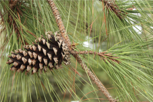
Cone of Loblolly Pine, attached directly to the stem
The outer (dorsal) surface of each seed cone scale has a diamond-shaped bulge, or “umbo,” formed by the first year’s growth. The umbo may or may not be armored with a “prickle,” a sharp point but not quite a spine or thorn, at the tip. As the seed cone continues to grow and expand, the exposed area at the end of each scale grows as well. The larger diamond-shaped area around the umbo, formed in the second year of growth, is called the “apophysis.” The shapes of the prickle, umbo, and apophysis can be helpful in identification. The male and female cones are separate structures, but both are present on the same plant. Pollen is produced by male cones and is carried by the wind to female cones where it fertilizes the ovules. Seeds develop and mature inside the female cones (also called the seed cones) for two years, protected by a series of tightly overlapping woody scales. Some pines open their seed cones after two years to release the seeds, while other pines continue to keep their cones tightly closed past maturity and release seeds in response to the heat of a forest fire.
To learn more about Florida’s pines and helpful hint on identification go to:
http://edis.ifas.ufl.edu/pdffiles/fr/fr00300.pdf
by hollyober | Mar 20, 2019
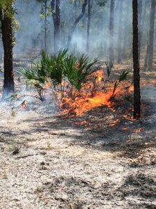
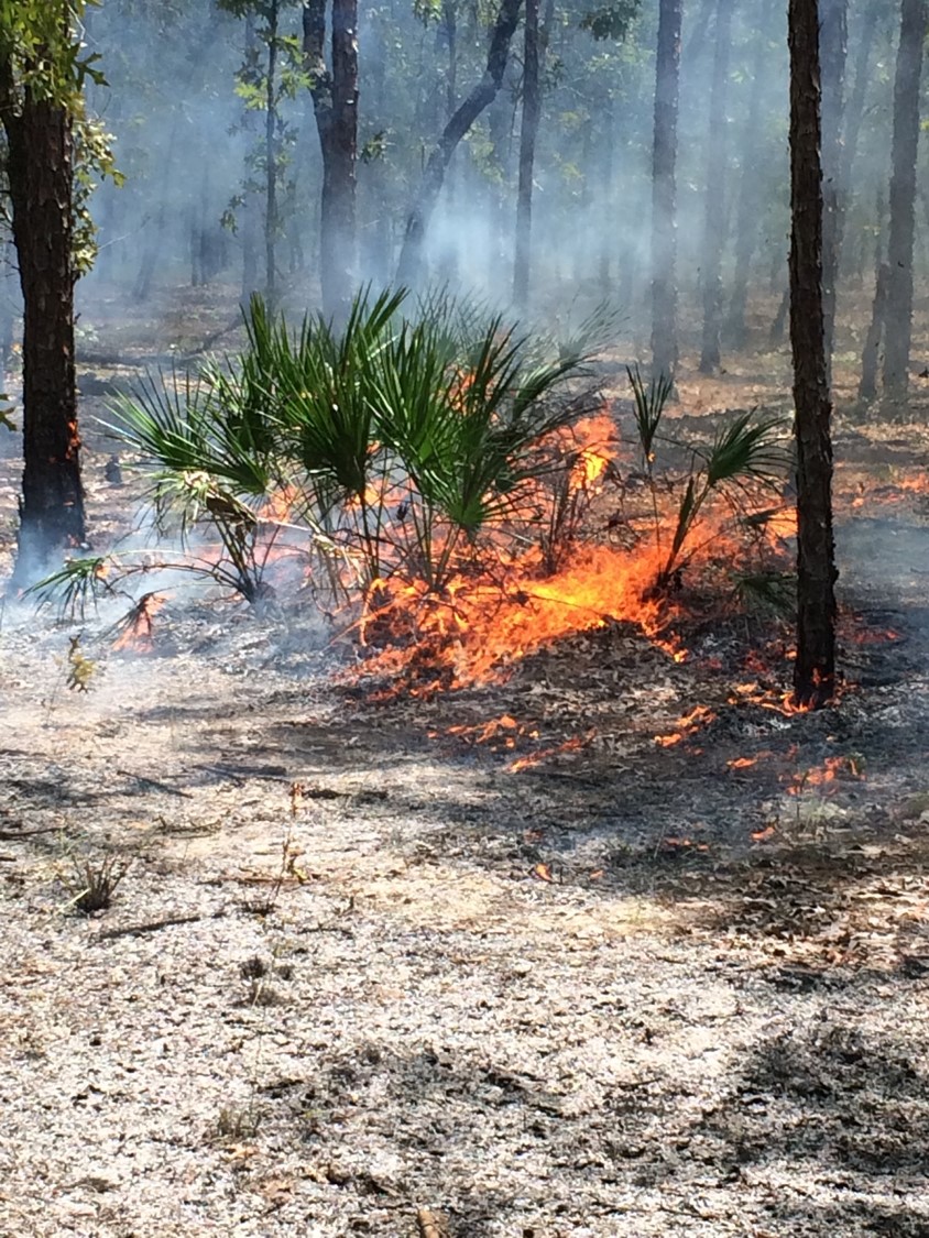
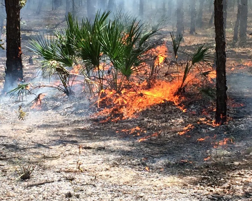
A prescribed fire burns safely in a natural area. Photo by Holly Ober.
Most plant and wildlife communities in Florida are adapted to periodic fires. For thousands of years, fires were ignited naturally, and frequently, by lightning. In fact, Florida has the greatest number of lightning strikes of any state in the country. About 1,000 lightning-set fires are documented in Florida each year.
Today, due to the many people living in Florida, the vast majority of fires naturally ignited by lightning are quickly suppressed by trained personnel. This is done to reduce the loss of human life and property. Although helpful to human safety in the short term, suppression of fire from natural areas for long periods of time can be problematic for all the native plant communities and wildlife that are adapted to periodic fire, and ultimately dangerous for humans as well. The longer our natural areas go unburned, the greater the accumulation of vegetative material that could serve as fuel for fire, and the greater the possibility of uncontrollable wildfires devastating natural areas, homes, and buildings when lightning strikes.
PRESCRIBED FIRES are an important tool: they are a safe alternative to wildfires. Prescribed fires are intentionally set under favorable weather conditions with the goal of stimulating the ecological benefits produced by natural wildfires. By selecting safe conditions for these burns and by preparing for them in advance by creating barriers to halt the spread of fire past desired borders, trained personnel have much more control over the results of these fires. The reason we often see and smell smoke in the spring is because this is the most popular time of year to use prescribed burning as a forest management tool.
Below are some of the benefits fire provides to the health of the many plants and wildlife that naturally occur in our state.
- Fire maintains required habitat conditions for many of Florida’s plant and wildlife species.
- Fire promotes fruit production of many woody plant species.
- Fire promotes flowering of herbaceous (non-woody) plant species.
- Fire promotes diverse herbaceous plants that serve as food for insects and wildlife.
- Fire scarifies seeds, breaking down their hard seed coats and promoting germination.
- Fire prepares sites for seeding or planting of species that require bare mineral soil.
- Fire creates growing conditions required by some cone-bearing trees. It reduces leaf litter on the soil surface, increases nutrient reserves, and canopy openings so that sunlight can reach the forest floor.
- Fire releases nutrients bound up in dead organic matter, ultimately increasing palatability, digestibility, and nutritional value of growing plants for wildlife.
- Fire can improve the quality of forage for grazing livestock.
- Fire changes the density of trees in the forest, creating space for some wildlife species.
- Fire removes hardwood thickets and vines in the understory of pine forests, making these areas more suitable for some wildlife species.
- Fire controls insect pests and diseases that afflict pine trees.
- Fire increases the rate of nutrient cycling of some elements and elevates soil pH.
- Fire creates a diverse habitat conditions when fires are patchy, leaving pockets of unburned areas.
- Fire reduces the risk of severe, high intensity wildfires that could cause harm to native plants and wildlife by preventing the accumulation of highly-flammable, dead vegetation.
The last week in January has been designated as Prescribed Fire Awareness Week in Florida. Early February has been designated as Prescribed Fire Awareness Week in Georgia. March is Prescribed Fire Awareness Month in South Carolina. Why are so many southern states making a big deal about prescribed fire? It is because we have recognized the importance of safe fires for both the health of our native plants and wildlife as well as the safety of our human residents and visitors. If you see or smell smoke in a nearby natural area, it might well be coming from a prescribed fire intended to benefit our natural plants and wildlife as well as our safety.
To learn more about prescribed burning in Florida, visit https://www.freshfromflorida.com/Divisions-Offices/Florida-Forest-Service/Wildland-Fire/Prescribed-Fire
by Andrea Albertin | Mar 20, 2019
By Vance Crain and Andrea Albertin
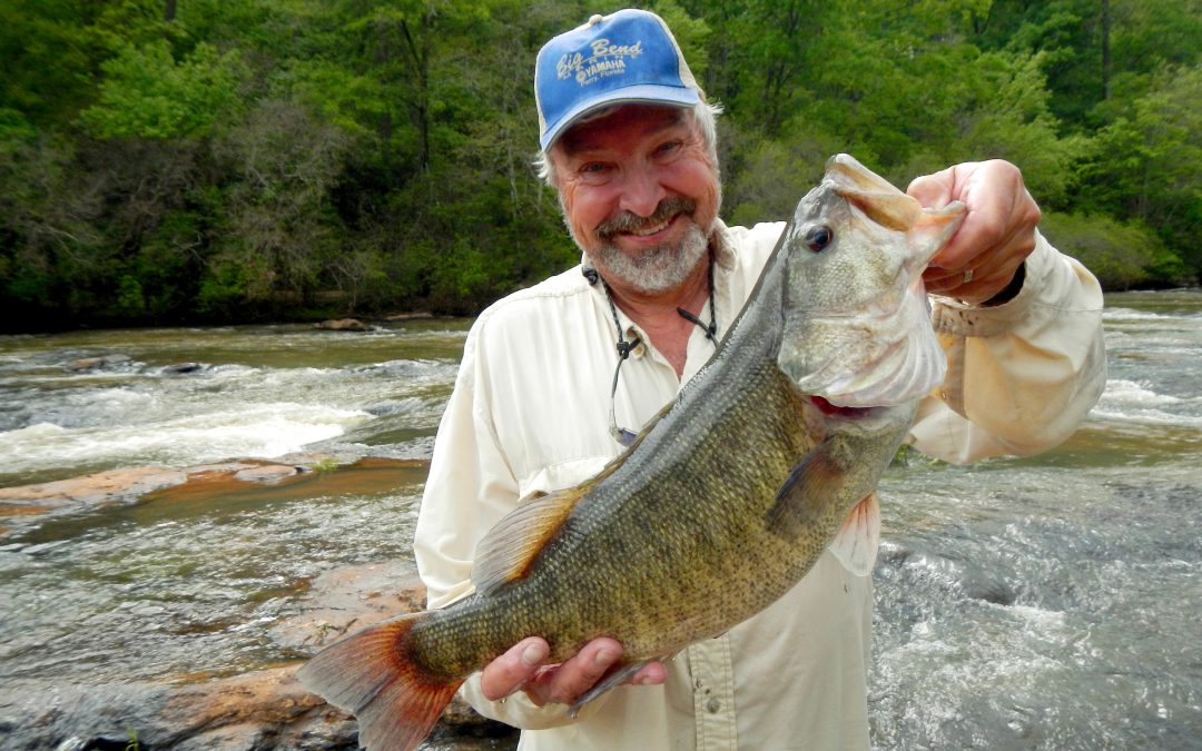
Fisherman with a large Shoal Bass in the Apalachicola-Chattahootchee-Flint River Basin. Photo credit: S. Sammons
Along the Chipola River in Florida’s Panhandle, farmers are doing their part to protect critical Shoal Bass habitat by implementing agricultural Best Management Practices (BMPs) that reduce sediment and nutrient runoff, and help conserve water.
Florida’s Shoal Bass
Lurking in the clear spring-fed Chipola River among limerock shoals and eel grass, is a predatory powerhouse, perfectly camouflaged in green and olive with tiger stripes along its body. The Shoal Bass (a species of Black Bass) tips the scale at just under 6 lbs. But what it lacks in size, it makes up for in power. Unlike any other bass, and found nowhere else in Florida, anglers travel long distances for a chance to pursue it. Floating along the swift current, rocks, and shoals will make you feel like you’ve been transported hundreds of miles away to the Georgia Piedmont, and it’s only the Live Oaks and palms overhanging the river that remind you that you’re still in Florida, and in a truly unique place.
Native to only one river basin in the world, the Apalachicola-Chattahoochee-Flint (ACF) River Basin, habitat loss is putting this species at risk. The Shoal Bass is a fluvial specialist, which means it can only survive in flowing water. Dams and reservoirs have eliminated habitat and isolated populations. Sediment runoff into waterways smothers habitat and prevents the species from reproducing.
In the Chipola River, the population is stable but its range is limited. Some of the most robust Shoal Bass numbers are found in a 6.5-mile section between the Peacock Bridge and Johnny Boy boat ramp. The Florida Fish and Wildlife Conservation Commission has turned this section into a Shoal Bass catch and release only zone to protect the population. However, impacts from agricultural production and ranching, like erosion and nutrient runoff can degrade the habitat needed for the Shoal Bass to spawn.

Preferred Shoal Bass habitat, a shoal in the Chipola River. Photo credit: V. Crain
Shoal Bass habitat conservation and BMPs
In 2010, the Southeast Aquatic Resources Partnership (SARP), the National Fish and Wildlife Foundation and a group of scientists (the Black Bass Committee) developed the Native Black Bass Initiative. The goal of the initiative is to increase research and the protection of three Black Bass species native to the Southeast, including the Shoal Bass. It also defined the Shoal Bass as a keystone species, meaning protection of this apex predators’ habitat benefits a host of other threatened and endangered species.
Along the Chipola River, farmers are teaming up with SARP and other partners to protect Shoal Bass habitat and improve farming operations through BMP implementation. A major goal is to protect the river’s riparian zones (the areas along the borders). When healthy, these areas act like sponges by absorbing nutrients and sediment runoff. Livestock often degrade riparian zones by trampling vegetation and destroying the streambank when they go down to a river to drink. Farmers are installing alternative water supplies, like water wells and troughs in fields, and fencing out cattle from waterways to protect these buffer areas and improve water quality. Row crop farmers are helping conserve water in the river basin by using advanced irrigation technologies like soil moisture sensors to better inform irrigation scheduling and variable rate irrigation to increase irrigation efficiency. Cost-share funding from SARP, the USDA-NRCS and FDACS provide resources and technical expertise for farmers to implement these BMPs.

Holstein drinking from a water trough in the field, instead of going down to the river to get water which can cause erosion and problems with water quality. Photo credit: V. Crain
By working together in the Chipola River Basin, farmers, fisheries scientists and resource managers are helping ensure that critical habitat for Shoal Bass remains healthy. Not only is this important for the species and resource, but it will ensure that future generations can continue to enjoy this unique river and seeing one of these fish. So the next time you catch a Shoal Bass, thank a farmer.
For more information about BMPs and cost-share opportunities available for farmers and ranchers, contact your local FDACS field technician: https://www.freshfromflorida.com/Divisions-Offices/Agricultural-Water-Policy/Organization-Staff and NRCS field office USDA-NRCS field office: https://www.nrcs.usda.gov/wps/portal/nrcs/main/fl/contact/local/ For questions regarding the Native Black Bass Initiative or Shoal Bass habitat conservation, contact Vance Crain at vance@southeastaquatics.net
Vance Crain is the Native Black Bass Initiative Coordinator for the Southeast Aquatic Resource Partnership (SARP).
by Laura Tiu | Jan 31, 2019
They say that dreams don’t work unless you take action. In the case of some Walton County Florida dreamers, their actions have transpired into the first Underwater Museum of Art (UMA) installation in the United States. In 2017, the Cultural Arts Alliance of Walton County (CAA) and South Walton Artificial Reef Association (SWARA) partnered to solicit sculpture designs for permanent exhibit in a one-acre patch of sand approximately .7-miles from the shore of Grayton Beach State Park at a depth of 50-60 feet. The Museum gained immediate notoriety and has recently named by TIME Magazine as one of 100 “World’s Greatest Places.” It has also been featured in online and print publications including National Geographic, Lonely Planet, Travel & Leisure, Newsweek, The New York Times, and more.
Seven designs were selected for the initial installation in summer of 2018 including: “Propeller in Motion” by Marek Anthony, “Self Portrait” by Justin Gaffrey, “The Grayt Pineapple” by Rachel Herring, “JYC’s Dream” by Kevin Reilly in collaboration with students from South Walton Montessori School, “SWARA Skull” by Vince Tatum, “Concrete Rope Reef Spheres” by Evelyn Tickle, and “Anamorphous Octopus” by Allison Wickey. Proposals for a second installation in the summer of 2019 are currently being evaluated.
The sculptures themselves are important not only for their artistic value, but also serve as a boon to eco-tourism in the area. While too deep for snorkeling, except perhaps on the clearest of days, the UMA is easily accessible by SCUBA divers. The sculptures are set in concrete and contain no plastics or toxic materials. They are specifically designed to become living reefs, attracting encrusting sea life like corals, sponges and oysters as well large numbers and varieties of fish, turtles and dolphins. This fulfills SWARA’s mission of “creating marine habitat and expanding fishery populations while providing enhanced creative, cultural, economic and educational opportunities for the benefit, education and enjoyment of residents, students and visitors in South Walton.”
The UMA is a diver’s dream and is in close proximity to other Walton County artificial reefs. There are currently four near-shore snorkel reefs available for snorkeling and nine reefs within one mile of the shore in approximately 50-60 feet of water for additional SCUBA opportunities. All reefs are public and free of charge for all visitors with coordinates available on the SWARA website (https://swarareefs.org/). Several SCUBA businesses in the area offer excursions to UMA and the other reefs of Walton County.
For more information, please visit the UMA website at https://umafl.org/ or connect via social media at https://www.facebook.com/umaflorida/.
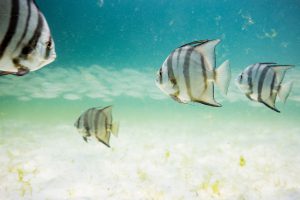
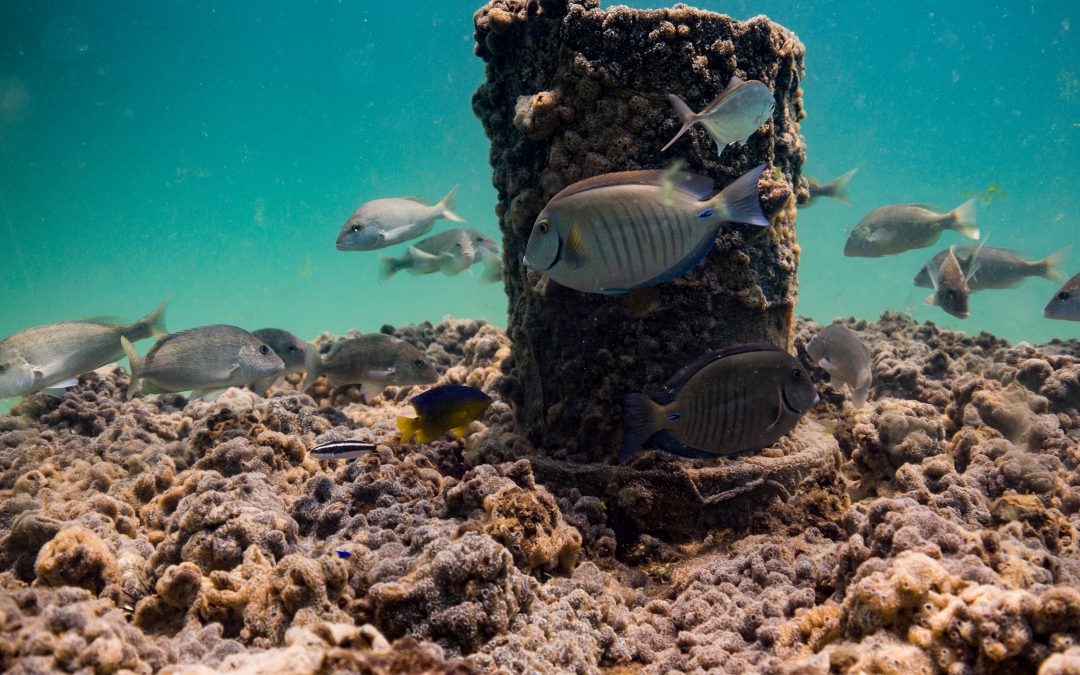
Schools of fish swim by the turtle reef off of Grayton Beach, Florida. Photo credit: University of Florida / Bernard Brzezinski
by Rick O'Connor | Jan 4, 2019
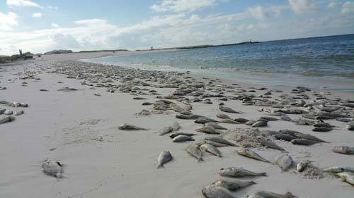
It has been one crazy year in the world of natural resources in the Florida panhandle. I guess the top stories would be the red tide and, of course, Hurricane Michael. Both had an impact environmentally and economically in the area.
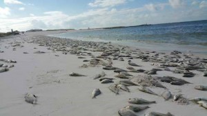
Dead fish line the beaches of the Florida Panhandle after a coast wide red tide event in October of 2015.
Photo: Randy Robinson
We did not see the red tide in the panhandle until late summer. The folks in southwest Florida had been dealing with it since late winter. Down there, large fish kills were driving away tourists and halting the charter fishing industry. People began canceling their hotel reservations and moving to the east coast of the state, which eventually had red tide as well. One report showed a 6% decrease in tourism for that region, may have been more. It was certainly devastating and there is now a bill in U.S. congress to fund red tide research and monitoring. They are wanting to be able to predict them better, and possibly reduce their impacts.
Here in the panhandle the economic impact was not as large. One, it came later in the year – beyond our busy season, and two Hurricane Michael occurred, which had a far greater environmental and economic impact. That said, FWC will continue to monitor for red tide and hope it will not be a story this year.
Hurricane Michael was huge as far as environmental and economic impacts for the natural resources in the region. Charter captains either had no boats, no crew, no marina, or no customers – in some cases, all of the above, and business suffered. For some fishing interest, we were past the closed season but for divers, and other fishing interest, the loss was definitely felt.
It was no different for the commercial fishing industry. In addition to boat, crew, and marina issues, oyster cages in the Apalach area were tossed up on beaches or lost all together. Product leaving the area, if you could harvest, was okay – but for those looking for local seafood in the area you had the problem with closed restaurants and seafood markets.
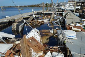
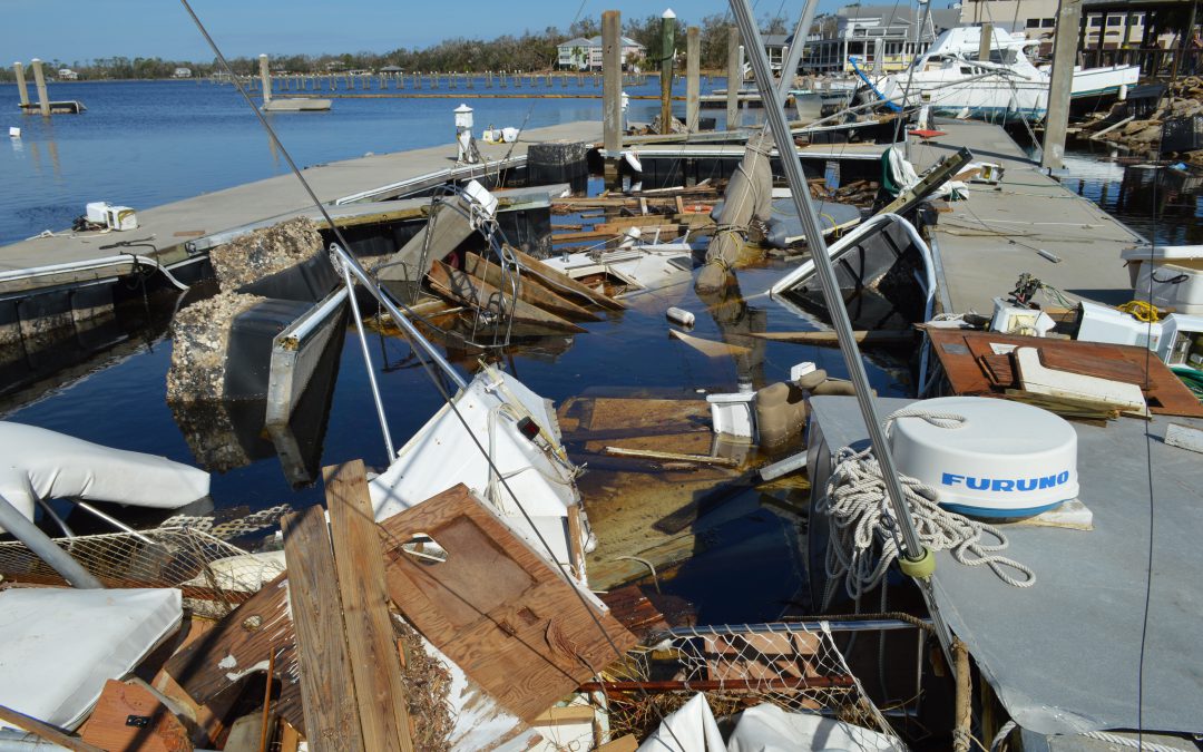
Here is an example of the damage to local marinas and vessels that service our local fisheries. Unseen is the economic damage to fishing crews and supporting shore base businesses such as seafood processors, bait and tackle shops, and tourism related businesses. (Photo by Allen Golden).
Above the coast, there were problems with downed trees – making commuting impossible and, in some cases, costing landowners a lot of money. Pecan orchards were hit hard, as were some of the timber interest. There were reports of livestock loose due to crushed fences from downed trees. Those they could hold on to did not have barns to put them in and feed was in low supply.
Then you had to be concerned about the quality of the water. Excessive rain equals high levels of bacteria, even in private wells there could be contamination. With time all things tend to return. Some local residents may be restoring their natural resources for some time, others may be back in business now. It was a tough hit for the area this year.
Other natural resource notes for 2018 include bear sightings. This continues to be an issue in the panhandle, particularly in Santa Rosa County. There have been manatees visiting the Big Lagoon area of Pensacola Bay during the last two years – something they do not often see. Also, in the Pensacola area has been an increase in calls about venomous snakes. Hard to say if there are more snakes than there once were, or whether they are becoming more visible, but it was a story that we will continue to watch this year.
At the 2018 FWC lionfish summit it was mentioned that lionfish are harder to find in waters shallower than 120’, this is good news. The story is not over yet but seems the harvesting we have been doing has helped. We will be having a regional lionfish workshop February 19 in Ft. Walton Beach for those interested in learning more about this issue. That will be followed the next day with a workshop on local artificial reefs. Registration information will be posted soon.
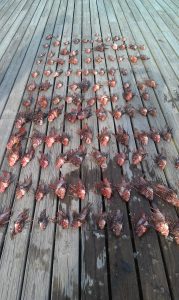
Harvested lionfish. Photo Credit: Bryan Clark
As we now look at 2019 there will certainly be new natural resource stories. There are a couple of bills recently introduced at the state level dealing with septic tank inspections, lawn fertilizer, maintaining our springs, and sewage spills designed to help improve water quality – we will see what happens with those. There is much discussion on coastal resiliency and how to reduce the impacts of future hurricanes and we will continue to monitor changes in our area such as invasive species and mangrove distribution.
If you have a topic you would like to see an article about, please let us know. We hope you had a great holiday season and we look forward to a good new year.
by Les Harrison | Jan 4, 2019
Florida’s park system has many unique and quality experiences to offer visitors, but few stand out as much as The Edward Ball Wakulla Springs State Park. It is home of the world’s largest and deepest freshwater springs.
The brisk water is home to manatees, alligators and a host of diverse wildlife which can be viewed from the shore or a boat. Each season delivers a different selection of birds passing through and offering birdwatchers a prime destination to see the avian residents and visitors in a natural setting.
The bracing, some say chilly, 70 degree waters are sure to refresh bathers even during the hottest summer days. For some human visitors ankle deep is enough to experience.
Wakulla Springs’ history extends back thousands of years with evidence of varied use by people and animals, some long gone. Early residents lived in shoreline villages and took advantage of the plentiful natural resources to support their idyllic existence.
One novel use of the area was by filmmakers who appreciated the primeval quality of the park’s swamps and wildlife as a backdrop for cinematic productions. Hollywood films such as Tarzan’s Secret Treasure (1941) and Creature from the Black Lagoon (1954) were shot at this location.
The historic lodge is an elegant remnant of old Florida, and set among the ancient cypress trees which surround the swamps. The Spanish style lodge with its period furniture, original elevators and colorful painted ceilings that depicts wildlife and Old Florida scenes still takes lodgers.
For the adventurous, there are several hiking trails requiring varying degrees of exertion. For more information about the park’s amenities visit their website: https://www.floridastateparks.org/parks-and-trails/edward-ball-wakulla-springs-state-park