Water Management Summit Flyer. Great Speakers and Topics for Irrigation and Turf Professionals.
Water is a precious natural resource that often makes headlines. Here in Northwest Florida we have Areas of Special Concern in which it has been determined that availability will not meet the needs as our population grows. Now is the time to make all efforts to conserve this valuable commodity. For those in the landscape industry, water plays a big part in their livelihood. To learn more about water conservation and related issues please attend this Third Annual event January 31, 2013 from 8:00 – 4:30. $15 in advance, $20 at the door. Door Prizes Available for those who registered in advance by January 25! To pre-register call Sheila Dunning, Okaloosa County Commercial Horticulture Extension Agent – 850.689.5850.
Water Use Update – Lauren Connell, Hydrogeologist, Resource Regulation, Northwest Florida Water Management
Landscape Irrigation Water Requirements, What Does the Science Say? – Michael Dukes, Ph.D., Irrigation Specialist, University of Florida
Urban Irrigation Smart Controller Retrofits – Kati Migliaccio, University of Florida, Tropical Research and Education Center
Reclaimed Water – Tom Shannon, Ewing Irrigation
Practical Considerations for Minimizing Environmental Impact of Turf Maintenance – Bryan Unruh, Ph.D., Turfgrass Professor and Associate Center Director, University of Florida, West Florida Research and Education Center
Damage Prevention – Brad Martin, Sunshine One Call 811
No matter our distance from a lake, wetland, river, or coastline, we all live within the boundaries of a watershed – photo by Judy Ludlow
No matter our distance from a lake, wetland, river, or coastline, we all live within the boundaries of a watershed. In fact, all land on earth is part of a watershed and all habitats exist within a watershed boundary. The size of watersheds can vary from a few square feet to millions of acres. It is important to realize our location is always within a watershed. All domestic, agricultural, horticultural, or industrial activities that occur in a specific watershed will impact surrounding water quality and quantity.
The United States Environmental Protection Agency defines a watershed as “an area of land where all of the water that is under it or drains off of it goes to a common waterway, such as a stream, lake, estuary, wetland, aquifer, or even the ocean.” Think of a watershed as a bowl or basin formed by the elevation of surrounding terrain. Gravity moves rainwater, surface water, and groundwater down the basin to its lowest point ending in a body of water.
Being aware of your actions within the watershed is important to the long term water quality and quantity of your favorite panhandle Florida lake, river, or spring run – photo by Judy Ludlow
With that description in mind (water moving to the lowest point), think about the daily activities within your watershed. Watersheds contain houses, cars, businesses, natural areas, timber lands, agriculture, gardens, golf courses, shopping malls, pavement, septic systems, factories etc. So no matter where we are within our watershed, whatever falls to the ground (wash water, chemicals, fertilizers, fuels, oils, wastes, etc.) within that watershed will flow “downhill” to the water system that drains it. You may think the accidentally spilled motor oil may never reach the nearest lake, but it will impact the surface water and/or ground water as it moves downhill through the watershed. You may also think one isolated spill is insignificant. Keep in mind however; the more densely populated a watershed is, the greater the frequency and volume of impacts to surface and ground water will be.
Whether you are a business or individual, becoming aware of your watershed “address” is a novel way to view your essential connection to your water resources. Becoming aware, also, of your actions within the watershed, is important to the long term water quality and quantity of your favorite Panhandle lake, river, or spring run.
For more information about locating your watershed “address” and about watershed management please see the following resources.
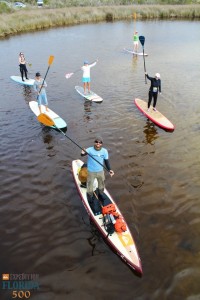
It is human nature to explore. We are a curious species, yearning from birth to stimulate our senses of sight, smell, touch…from an infant’s grab at a colorful toy to an astronaut setting foot on the moon, we thrive on new adventures and understanding. A legend of the Age of Exploration, Spanish explorer Ponce de Leon set foot on Florida’s coast in 1513, and 500 years later, another water-based expedition is taking place. This time, the explorer sets out not to conquer, but to celebrate the unique ecology and history of Florida. On January 1, University of Florida graduate Justin Riney, founder of a nonprofit advocacy group called Mother Ocean, launched a 365 day standup paddleboard journey around the state. Several standup paddleboarding enthusiasts (myself included) joined him at Big Lagoon State Park in Pensacola to begin the 1,515 mile Florida Circumnavigational Saltwater Paddling Trail, which hugs the coastline south through the Keys and back north to Jacksonville.
The author (top right) participates in the launch of Expedition Florida 500 at Big Lagoon State Park on January 1. Photo Credit: Jackson Berger
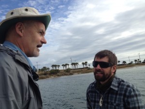
Justin plans to paddle for at least 10 miles a day, carrying all of his gear on his board and camping at beaches in each community. The goal of the trip is not only to help celebrate the 500th anniversary, but he’s partnered with the Florida Department of Environmental Protection, the University of Florida, and several watersports companies to promote the expedition and highlight conservation of the springs, rivers, estuaries and beaches around our state. He hopes the journey will inspire people to explore and protect our invaluable water resources, and encourages locals to join him at each location to paddle and share knowledge about their waterways. Along the route, he has scheduled almost three weeks to take daylong tours in areas of particular ecological and historical significance. Today several of us joined him on a trip through Pensacola Bay, where we discussed everything from the history of Fort Pickens, to the improvement of water quality in Bayou Chico, to the Appalachian origins of our sugar-white sands.
Captain Robert Turpin, Escambia County Marine Resources (left), discusses seagrass preservation in Little Sabine Bay with Justin Riney.
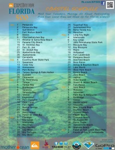
In several communities, he plans to lead coastal cleanups. Justin will be paddling from Pensacola through Gulf Breeze tomorrow and to south Okaloosa and Walton counties through January 11. From there, he will continue along the coast, and on to Bay and Franklin counties between the 15-26 of this month. The detailed schedule below outlines his route from the Panhandle and beyond.
Coastal Schedule for Expedition Florida 500
You can follow Justin’s experiences at Expedition Florida 500 on Facebook to see updates, photos, and information about where he will be next. If you’re a standup paddleboarder, kayaker, or just interested in the project, contact him through the page and take the time to be part of this historic journey. And for those of you who live further inland, after reaching Jacksonville on July 4, he plans to paddle back through the state exploring inland waterways–rivers, springs, and lakes–so there’s a good chance Expedition Florida will come to your community this year as well!
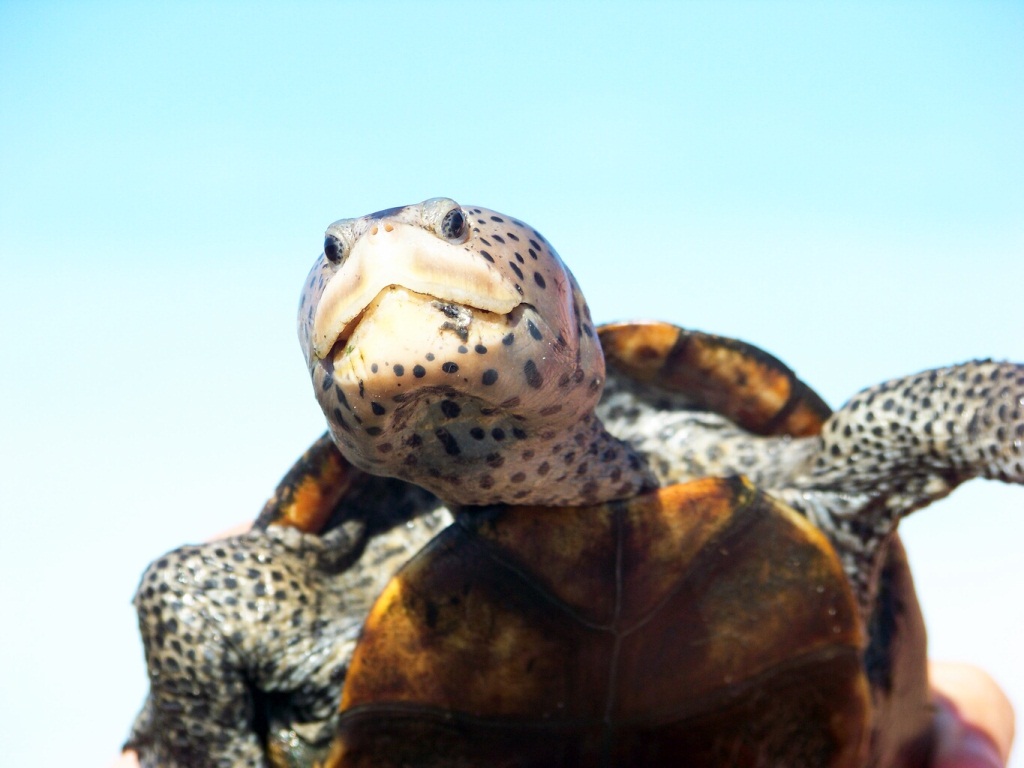
It is hard to say one turtle is more beautiful than another but this is one beautiful turtle! The diamondback terrapin is the only brackish water turtle in the United States. These turtles can be easily distinguished from other species by their light colored skin with dark spots, and their choice of habitat – salt marshes.
Ornate Diamondback Terrapin (photo: Dr. John Himes)
Terrapins inhabit creeks within marshes close to where they were born and rarely range from their natal home. They require dry ground for nesting. Terrapins spend their time basking in lagoons near the surface or on open mudflats at low tide. They feed primarily on shellfish, preferring snails and bivalves, but will also feed on small crabs, shrimp, worms, fish, and occasionally vegetation.
The females are larger than the males and have shorter tails. Mature females typically lay 6 to 10 eggs and will nest more than once in the same year. Nesting begins in late April in our part of the country and females laying multiple clutches will do so every 16 days. The sex of the offspring is determined by the nest temperature (warmer than 29˚C = females) so generally the eggs in the upper part of the nest are female. Unlike sea turtles, female terrapins approach the nesting beach at high tide during daylight hours. Most of the nests we find in Santa Rosa County are near salt bush (Baccharis sp.) but we have found them in open areas or near debris like driftwood. They also differ from sea turtles in that young head away from open water preferring the plants of the marsh. The heaviest predation is on the eggs and young. The dominant nest raider is the raccoon. Hatchlings are preyed upon by raccoons, otters, skunks, crows, and sea gulls; adults have few predators.
Terrapin populations have declined over the last 150 years. In the late 19th century it became very popular to eat them and the demand for the animal became an economic dynamo for many coastal fishermen. Terrapin researchers from the University of Alabama at Birmingham found a newspaper article from that time period that discussed a terrapin farm in Mobile County that had 25,000 terrapins; suggesting they were once very common. With the increase in the popularity for food their numbers decreased, this caused an increase in price and a decline in their popularity. The introduction of the crab trap in the 20th century became problematic for them. Terrapins swim into traps and can not reach the surface to breathe. In some states a “by-catch reduction device” or BRD is required on crab traps. Studies of these in New Jersey and Florida showed they have no significant impact on the crab catch but do reduce the number of terrapins captured. BRDs are not currently required in Florida as commercial traps are actively fished and bycatch removed when crabs are harvested. “Derelict” crab traps are those that are not actively being fished, killing all sorts of aquatic life. Derelict crab trap removal events which removes this potential hazard to turtles and to blue crabs as well.
We have been conducting a monitoring program assessing the status of Terrapins in the Panhandle since 2006 and have found at least one in every coastal county between Alabama and the Apalachicola River. We have identified five nesting beaches and believe that one population has between 25-50 individuals within it (likely much lower numbers than historically found). The marsh turtle status is certainly of concern for many biologists.
To learn more about terrapins and the crab trap removal program visit the following websites or call your local extension office. For more information on obtaining a bycatch reduction device (BRD) for your recreational crab traps contact Rick O’Connor, 850-475-5230.
Terrapins in a derelict crab trap (photo: Molly O’Connor)
Photo Courtesy of NOAA – Car bodies and other thin metal materials such as appliances were once used to create artificial reefs. Monitoring revealed these materials deteriorate quickly.
History of Artificial Reefs and Materials Ancient mariners observed large numbers of fish inhabiting areas near sunken vessels. Our first sailors quickly realized objects placed in the sea are almost immediately colonized by marine life.
Based on these early observations, the first artificial reefs were constructed from materials purposefully put underwater to enrich marine life. New reefs were mainly constructed from deteriorating vessels or “materials of opportunity”.
In the 1830s, artificial reef pioneers in South Carolina experimented using log huts, which they discovered deteriorated in a few short years. Locally, in the Florida Panhandle, as early as the 1950s and 60s, railroad cars, school buses, car bodies, white goods (stoves, refrigerator, washer, etc.), tires, and even porcelain fixtures were used to create artificial reefs.
Today’s artificial reef materials are no longer the “underwater junk yards” of the past but marine resources that are carefully deployed and calculated to last at least 20 years without harm to wildlife or the environment. Decommissioned steel hulled ships, military surplus, nested concrete culvert, and durable “materials of opportunity” are still utilized today. Additionally, new engineered concrete artificial reef modules that support specific species and various life stages of fish have been developed. Current fisheries research seeks to refine materials, design, and placement of artificial reefs to maximize conservation through planned monitoring activities.
Courtesy of Florida Sea Grant. In total, it takes about 3 – 5 years for reefs to reach a level of maximum production for both fish and invertebrate species.
Within hours of sinking a vessel or concrete reef, baitfish move into their new home. This initiates a “parade” of marine life over several months. The hard structure of an artificial reef is slowly colonized by soft corals, sponges, plants, and barnacles. Baitfish will soon have new neighbors, as snapper and grouper take residence. Nearby sand sediments come to life with sea stars, sand dollars, and other invertebrate species.
Attraction vs. Production Almost as old as the history of artificial reefs is the question of attraction vs. production. Do artificial reefs actually increase the fish population or merely increase the number of fish being caught? Researchers struggled with this question for decades producing seemingly conflicting results. Today’s consensus is that the answer to the question is both yes and no – it depends.
When fishing pressure and mortality exceed the number of fish produced, artificial reefs can end up as expensive fishing equipment. It’s in everyone’s interest to avoid this situation and create productive resources.
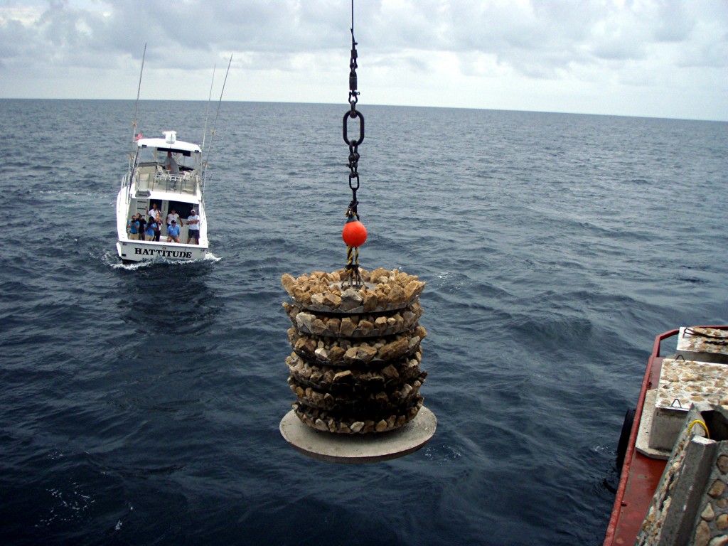
Photo Courtesy of Okaloosa County Sea Grant and Joy Brown. Engineered concrete reefs with limestone rock. Modules are easily stacked for transport and then deployed by crane to create patch reefs.
Fisheries Management Tools Artificial reefs are best used as a fisheries conservation tool that disperses fishing pressure and promotes healthy fish stocks. Reefs are strategically deployed so that the exposure to fishing pressure is limited by either time or by geographic location. The ultimate goal when using artificial reefs is for fish production to exceed any fishing or natural mortality.
Economic Benefits of Artificial Reefs
Our artificial reefs support more than just fish. They support jobs and people that earn a living from tourism associated with diving and fishing. In 1998, Florida State University researchers, estimated fishing and diving activities supported nearly 8,136 jobs and 84 million dollars in salary each year in Escambia, Santa Rosa, Okaloosa, Walton, and Bay counties. Despite the age of the study, it provides an idea of how vital artificial reefs and marine recreation are to Northwest Florida.
Photo Courtesy of Florida Fish and Wildlife and Bill Horn. Different types of modules are now being deployed together. Innovations like this narrow spaced ecosystem reef help expand the diversity of fish species and ages supported in today‘s reef designs.
How to Access Northwest Florida’s Artificial Reefs


")