by Rick O'Connor | Nov 4, 2021
At the time of this writing, red tide is still lingering off the Pensacola coast. By the time this is posted it may or may not be. I have had a few questions about red tide while this has been occurring here, and some misconceptions about it – so, now is a good time to try and set the story straight.
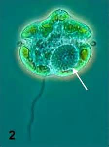
The dinoflagellate Karenia brevis.
Photo: Smithsonian Marine Station-Ft. Pierce FL
Red tide is actually caused by a group of small, single-celled marine plants. The one responsible for the red tide in the Gulf of Mexico is called Karenia brevis. Karenia is a naturally occurring dinoflagellate. If I were to pull a water sample off of Pensacola Beach right now I would find it there – albeit in small concentrations – say 300-500 cells in a liter of water. At these concentrations there are no problems. When we say problems, we mean respiratory problems or fish kills. See, Karenia is a dinoflagellate that when irritated or disturbed, will release a toxin – brevotoxin. This toxin is a neurotoxin that is known to kill fish, sea turtles, and marine mammals at high concentrations – greater than 1,000,000 cells / liter. For humans the issue is more of respiratory and eye irritation. Though consuming filter feeding shellfish, such as oysters and scallops, during a red tide can cause serious gastrointestinal problems and possibly hospitalization in humans. This is why the state closes shellfish harvesting when Karenia concentrations reach 5,000 cells / liter.
What causes Karenia concentrations to increase from 500 cells to 5,000 cells, or even 1,000,000 cells / liter?
The same thing that causes all plants to grow – sunlight and nutrients.
Here is where the first misconception arises.
“Red tides are caused by the increase of nutrients in the ocean due to human activity”.
Not exactly correct. Red tides have occurred in the Gulf of Mexico since the colonial period, and the colonists certainly did not discharge enough nutrients to spawn a red tide bloom. No, these blooms occur naturally. Most form off the coast of southwest Florida. There the continental shelf extends about 200 miles offshore before reaching the slope to the deep sea. At this slope there are upwelling currents bringing nutrients from the seafloor to bath these phytoplankton in the warm Florida sun. This combination, along with some other water chemistry needs, fuel the growth of phytoplankton from a few hundred cells / liter to a few thousand, hundred thousand, or even a million cells / liter – an algal bloom. At concentrations of 1,000,000 cells or more the water actually changes color to reddish – hence the name “red tide”.
However…
Today humans ARE discharging large amounts of organic and inorganic nutrients into local waterways. These eventually make their way to the Gulf and can enhance a natural bloom from say 10,000 cells / liter to over 1,000,000 – we can make the situation worse. This typically happens when offshore winds blow the naturally occurring red tides closer to shore to meet our “cocktail of nutrients” and wa-la – an enhanced bloom with enhanced problems.
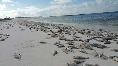
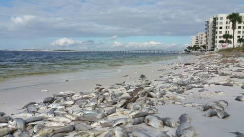
Dead fish line the beaches of the Florida Panhandle after a coast wide red tide event in October of 2015.
Photo: Randy Robinson
Here in the northern Gulf the conditions to spawn naturally occurring red tides do not typically exist. What we usually see are the blooms generated in southwest Florida pushed northward but weather patterns. At the time of this writing, Escambia County is experiencing a red tide offshore at background/very low concentrations (0-10,000 cells/liter). Though are no reports of fish kills or respiratory issues in humans, but these are happening to our east in Okaloosa, Walton, Bay, and Franklin counties.
The state is aware of the not only the red tide situation, but other harmful algal blooms occurring around the state and has a task force to try and address these. We, of course, can help by reducing the amount of nutrients (fertilizers) we discharge into our local waterways. This would include not only commercial fertilizers, but any plant and animal waste.
References
Red Tide Current Status. 2021. Florida Fish and Wildlife Conservation Commission. https://myfwc.com/research/redtide/statewide/?utm_content=&utm_medium=email&utm_name=&utm_source=govdelivery&utm_term=campaign.
by Rick O'Connor | Oct 21, 2021
Catfish…
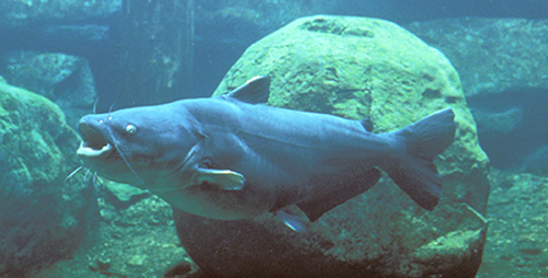
There are a lot of fish found along the Florida panhandle that many are not aware of, but catfish are not one of them. Whether a saltwater angler who captures one of those slimy hardhead catfish to a lover of freshwater fried catfish – this is a creature most have encountered and are well aware of.
Growing up fishing along the Gulf of Mexico, the “catfish” was one of our nemesis. Slinging your cut-bait out on a line, if you were fishing near the bottom, you were likely to catch one of these. Reeling in a slimy barb-invested creature, they would swallow your bait well beyond the lip of their mouths and it would begin a long ordeal on how to de-hooked this bottom feeder that was too greasy to eat. Many surf fishermen would toss their bodies up on the beach with the idea that removing it would somehow reduce their population. Obviously, that plan did not work but ghost crabs will drag their carcasses over to their burrows where they would consume them and leave the head skull that gives this species of catfish it’s common name “hardhead” catfish, or “steelhead” catfish. This hard skull has bones whose shape remind you of Jesus being crucified and was sold in novelty stores as the “crucifix fish”.
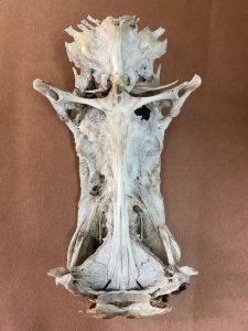
The bones in the skull of the hardhead catfish resemble the crucifixion of Christ and are sold as “crucifix fish”.
Photo: Rick O’Connor
When I attended college in southeast Alabama a group of friends wanted to go out for fried catfish. I, knowing the above about saltwater catfish, replied “why?… no…, you don’t eat catfish”. They assured me you did and so off we went to a local restaurant who sold them. Fried catfish quickly became one of my favorites. A fried catfish sandwich with slaw and beans is something I always look forward to. At that time, I was not aware of the freshwater catfish, nor the catfish farms that produce much of the fish for my sandwiches. I now have also become aware of the method of catching freshwater catfish called “noodling” – which is not something I plan to take up.
Worldwide, there are 36 families and about 3000 species of what are called catfish1. Most are bottom feeders with flatten heads to burrow through the substrate gulping their prey instead of biting it. Most possess “whiskers” – called barbels, which are appendages that can detect chemicals in the environment (smell or taste) helping them to detect prey that is buried or hard to find in murky waters. These barbels resemble whiskers and give them their common name “catfish”.
The serrated spines and large barbels of the sea catfish. Image: Louisiana Sea Grant
They lack scales, giving them the slimy feel when removing them from your hook, and also have a reduced swim bladder causing them to sink in the water – thus they spend much of their time on the bottom. The mucous of their skin helps in absorbing dissolved oxygen through the skin allowing them to live in water where dissolved oxygen may be too low for other types of fish1.
They are also famous for their serrated spines. Usually found on the dorsal and pectoral fins, these spines can be quite painful if stepped on, or handled incorrectly. Some species can produce a venom introduced when these spines penetrate a potential predator which have put some folks in the hospital1.
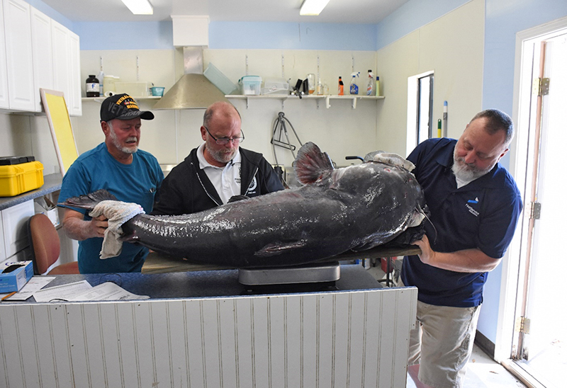
The size range of catfish is large; from about five inches to almost six feet. In North America, the largest captured was a blue catfish (Ictalurus furcatus) at 130 pounds. The largest flathead catfish (Pylodictis olivaris) was 123 pounds. But the monster of this group is the Mekong catfish of southeast Asia weighing in at over 600 pounds.
The Florida Fish and Wildlife Conservation Commission lists six species of catfish in the Florida panhandle area. However, they are focusing on species that people like to catch2.
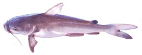
The Blue Catfish
Photo: University of Florida
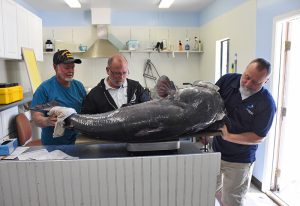
This large blue catfish is being weighed by FWC researchers. Photo: Florida Fish and Wildlife Conservation Commission
The Channel Catfish (Ictalurus punctatus) is found throughout Florida and also in many river systems of the eastern United States. It has found few barriers dispersing through these river systems. They are not typically bottom feeders having a more carnivorous diet.
The Flathead Catfish (Pylodictis olivaris) are relatively new to Florida and are currently reported in the Escambia and Apalachicola rivers. They prefer these slow-moving alluvial rivers.
The Blue Catfish (Ictalurus furcatus) were first reported in the Escambia and Yellow Rivers, there are now records of them in the Apalachicola. These catfish prefer faster moving rivers with sand/gravel bottoms and seem to concentrate towards the lower ends of major tributaries.
The White Catfish (Amerius catus) is found in rivers and streams statewide, and even in some brackish systems.
The Yellow Bullhead (Amerius natalis) are most often found in slow moving heavily vegetated systems like ponds, lakes, and reservoirs. It is reported to be more tolerant of poor water conditions.
The Brown Bullhead (Amerius nebulosus) live in similar conditions to the Yellow Bullhead.
The dispersal of freshwater catfish is interesting. How do they get from the Escambia to the Apalachicola Rivers without swimming into the Gulf and up new rivers? The answer most probably comes from small tributaries further upstream that can, eventually, connect them to a new river system. Scientists know that eggs deposited on the bottom can be moved by birds who feed in each of the systems carrying the eggs with them as they do. And you cannot rule out movement by humans, whether intentionally or accidentally.
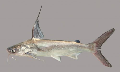
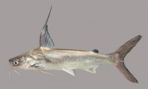
On the saltwater side of things, there are two species – though the blue catfish has been reported in the upper portions of some estuaries in low salinities in the western Gulf of Mexico. The marine species are the hardhead catfish (Arius felis), sometimes known as the “steelhead” or the “sea catfish” – and the gafftop (Bagre marinus), also known as the gafftopsail catfish3.
The hardhead catfish is very familiar with anglers along the Gulf coast. This is the one I was referring to at the beginning of this article. It is considered inedible and a nuisance by most. They are common in estuaries and the shallow portions of the open sea from Massachusetts to Mexico. They are reported to have an average length of two feet, though most I have captured are smaller. Like many catfish, they possess serrated spines on their dorsal and pectoral fins. Their distribution seems to be limited by salinity.
The gafftop is also reported to have a mean length of two feet, and most that I have captured are closer to that. At one point in time, we were longlining for juvenile sharks in Pensacola Bay and caught numerous of these thinking they were small bull sharks as we pulled the lines in, until we saw the long barbels extending from them. I remember this being a very slimy fish, covered with mucous, and not fun to take off the hooks. It is reported to have good food value, though I have not eaten one. They differ from the hardheads mainly in their extended rays from the dorsal and pectoral fins. The habitat and range are similar to hardheads, though they have been reported as far south as Panama.
The extended rays of the gafftop catfish.
Photo: University of Florida.
The diversity of freshwater catfish in the U.S. goes beyond what has been reported here. This group has been found on most continents and have been very successful. There are plenty of local catfish farms where you can try your luck, have them cleaned, and enjoy a good meal.
References
1 Catfish. Wikipedia. https://en.wikipedia.org/wiki/Catfish.
2 Catfish. Florida Fish and Wildlife Conservation Commission. https://myfwc.com/fishing/freshwater/sites-forecasts/catfish/.
3 Hoese, H.D., R.H. Moore. 1977. Fishes of the Gulf of Mexico; Texas, Louisiana, and Adjacent Waters. Texas A&M Press. College Station TX. Pp. 327.

by Rick O'Connor | Sep 23, 2021
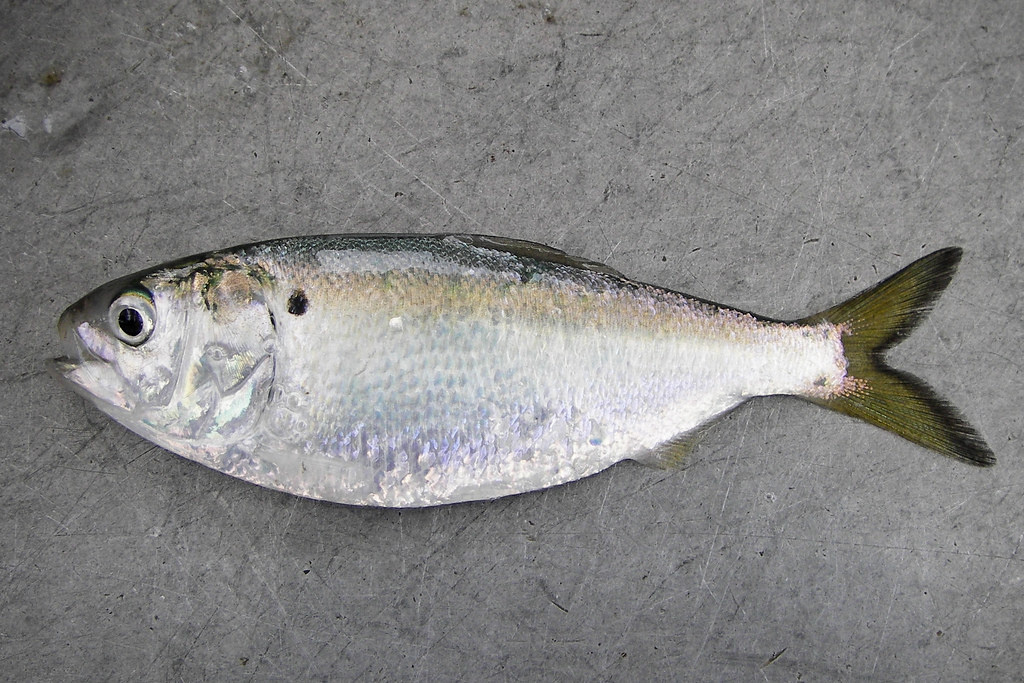
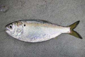
These are all fish that many have heard of but know nothing about. They are not even sure what they look like. We have heard of them as a seafood product. Smoked herring, canned sardines, and anchovy pizza are popular the world over. These are one of the largest commercial species harvested in U.S. waters. In 2020 over 6 million pounds of sardines, 12 million pounds of anchovies, 41 million pounds of herring, 1.3 BILLION pounds of menhaden were harvested. The menhaden catch alone was valued at just under $200 million2. It not as large a fishery in Florida. 327,000 pounds of menhaden, 700,000 pounds of sardines, and 1.8 million pounds of herring were harvested from state waters in 2020 and at value of about $900,000 in 2020. The fish are popular in many European dishes, cat food, and menhaden oil is used in many products.
The Gulf menhaden supports a large commercial fishery in the Gulf of Mexico.
Photo: NOAA
These fishes are actually divided into two families. The herring, sardine, and menhaden are in the Family Clupeidae and are often called “clupeids”. This family includes 11 species in the northern Gulf of Mexico. Most have a “hatchet” shape to their bodies – being straight along their back with a deep curve along the ventral side, and most having a forked, or lunate, tail. They average between 2-20 inches in length and form massive schools as they travel near the surface waters filtering plankton. They are often harvested using purse seines. Large factory vessels will plow the waters searching for the large schools. Often, they will use aerial assistance to search such as small airplanes or ultralights. Once spotted, small chase boats will be launched from the factory vessel hauling the large purse seine around the school. Once that is completed a large weight called a “tommy” is dropped that “zips” the purse shut and captures the fish. There is little bycatch in this method.
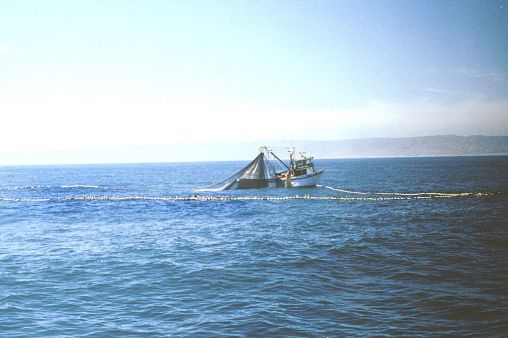
Purse seining in the Pacific Ocean.
Photo: NOAA
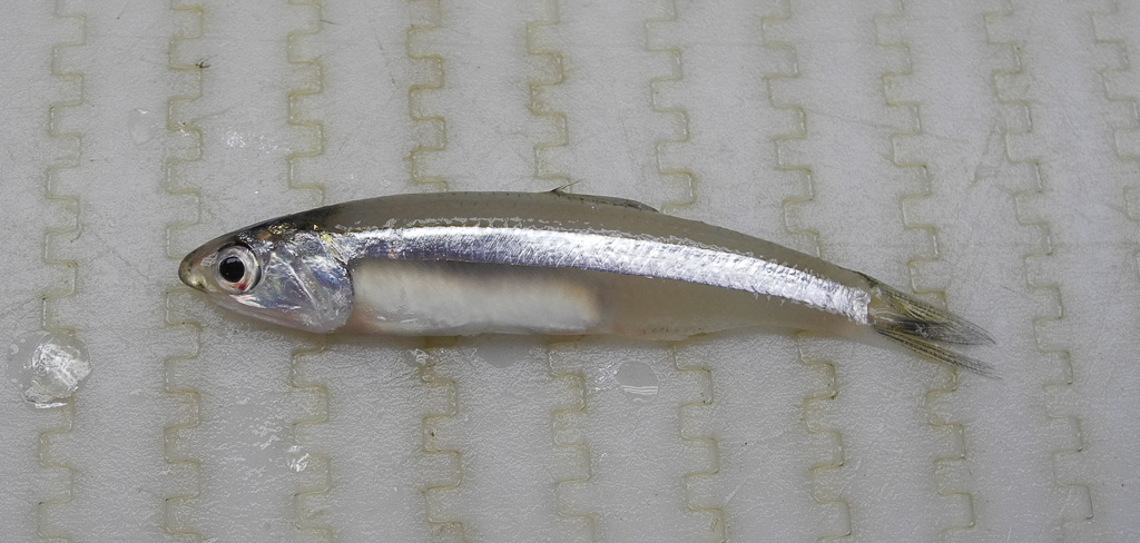
The anchovies are found in the family Engraulidae. They differ in that they are more streamlined in shape and their mouths are larger / body size than the clupeids. Though there is no commercial fishery for them in Florida, they comprise one of the largest groups of schooling fish in the northern Gulf of Mexico. Hoese and Moore mention that the local species are too small for a fishery. The five native species average between 2.5-5.5 inches in length1. Some marine biologists consider anchovies as an “environmental canary”, or indicator species. Their presence can suggest good water quality. I have often caught them in seines along the beach in the Pensacola area. They resemble the very common silverside minnow in that they have a silver stripe running down their sides. But they differ in that they (a) only have a single dorsal fin (silversides have two), and (b) their snouts extend to a point resembling the head of a shark.
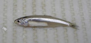
This striped anchovy resembles a silver side but differs with the shape of its snout and the number of dorsal fins.
Photo: NOAA
The distribution and biogeography of this group of fishes is all over the place. The round herring (Etrumeus teres) has few barriers and is found from the Bay of Fundy (at the Canadian/Maine border) to the Pacific Ocean1! A few species have the classic “Carolina” distribution – meaning they are found from North Carolina south, the entire Gulf of Mexico, and down to Brazil. For whatever reason (currents, water temperature, other) they do not venture north of the Carolinas and are probably impacted by the large amount of freshwater entering the Atlantic Ocean near the Amazon River.
Twp species are restricted by tropical conditions. The tiny dwarf herring (Jenkinsia lamprotaenia) and the Spanish sardine (Sardinella anchovia) are both listed as being restricted by water temperatures, though I have captured plenty of the Spanish sardines in the Pensacola area.
Some species are restricted to either the eastern or western Gulf of Mexico. Usually, the barrier for this distribution is the Mississippi River. Like the Amazon, there is a large plume of highly turbid/low salinity water extending into the Gulf of Mexico which keeps some species from crossing. Hoese and Moore report the Alabama shad (Alosa alabamae) only from the area between the Mississippi River and the Florida panhandle. The Mississippi River to one side, and the Apalachicola on the other.
Clupeids, like this Pacific sardine, for m large schools can consist of literally millions of fish.
Photo: NOAA
And finally, there is a spatial distribution with some species between freshwater, estuaries, and the open shelf. Two species, the threadfin shad (Dorosoma petenense) and the gizzard shad (Dorosoma cepedianum) are more associated with freshwater. The scaled sardine (Harengula pensacolae) is more common on the open shelf of the Gulf.
We all know the names of these fish but are unaware of their general biology and importance to commercial fisheries around the world. Many are common in our estuaries and play an important role in the health of the overall ecology. They are important members of the “panhandle fish family”.
References
1 Hoese, H.D., R.H. Moore. 1977. Fishes of the Gulf of Mexico; Texas, Louisiana, and Adjacent Waters. Texas A&M Press, College Station TX. Pp. 327.
2 NOAA Fisheries. 2021. Commercial Landings. https://www.fisheries.noaa.gov/foss/f?p=215:200:2082956461436::NO:::.
3 Florida Commercial Landings. 2021. Florida Fish and Wildlife Conservation Commission. https://myfwc.com/research/saltwater/fishstats/commercial-fisheries/landings-in-florida/.
by Laura Tiu | Sep 9, 2021
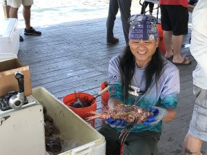
A Lionfish Removal and Awareness Day festival volunteer sorts lionfish for weighing. (L. Tiu)
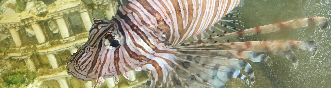
The northwest Florida area has been identified as having the highest concentration of invasive lionfish in the world. Lionfish pose a significant threat to our native wildlife and habitat with spearfishing the primary means of control. Lionfish tournaments are one way to increase harvest of these invaders and help keep populations down. Not only that, but lionfish are a delicious tasting fish and tournaments help supply the local seafood markets with this unique offering.
Since 2019, Destin, Florida has been the site of the Emerald Coast Open (ECO), the largest lionfish tournament in the world, hosted by Destin-Fort Walton Beach and the Florida Fish and Wildlife Commission (FWC). While the tournament was canceled in 2020, due to the pandemic, the 2021 tournament and the Lionfish Removal and Awareness Day festival returned to the Destin Harbor May 14-16 with over 145 tournament participants from around Florida, the US, and even Canada. The windy weekend facilitated some sporty conditions keeping boats and teams from maximizing their time on the water, but ultimately 2,505 lionfish were removed during the pre-tournament and 7,745 lionfish were removed during the two-day event for a total of 10,250 invasive lionfish removed. Florida Sea Grant and FWC recruited over 50 volunteers from organizations such as Reef Environmental Education Foundation, Navarre Beach Marine Science Station and Tampa Bay Watch Discovery Center to man the tournament and surrounding festival.
Lionfish hunters competed for over $48,000 in cash prizes and $25,000 in gear prizes. Florida Man, a Destin-based dive charter on the DreadKnot, won $10,000 for harvesting the most lionfish, 1,371, in 2 days. Team Bottom Time secured the largest lionfish prize of $5,000 with a 17.32 inch fish. Team Into the Clouds wrapped up the $5,000 prize for smallest lionfish with a 1.61 inch fish, the smallest lionfish caught in Emerald Coast Open History.
It is never too early to start preparing for the 2022 tournament. For more information, visit EmeraldCoastOpen.com or Facebook.com/EmeraldCoastOpen. For information about Lionfish Removal and Awareness Day, visit FWCReefRangers.com
“An Equal Opportunity Institution”
by Rick O'Connor | Aug 27, 2021
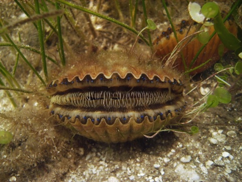
For those who lived in the Pensacola Bay area 50 or so years ago, this question comes up from time to time. By scallop I am speaking of the bay scallop (Argopecten irradians), the one sought by so many scallopers then and now. This relatively small bivalve sits on beds of turtle grass, gazing with their ice blue eyes, filtering the water for plankton and avoiding numerous predators. They only live for a year, maybe two. They aggregate in relatively large groups and mass spawn. Releasing male gametes first, then female, fertilizing externally in the water column, to create the next generation.
Bay Scallop Argopecten iradians
http://myfwc.com/fishing/saltwater/recreational/bay-scallops/
These are unique bivalves in that they can swim… sort of. When conditions are not good, or a predator is detected, they can use their single adductor muscle to open and close the shells creating a current of expelling water that “pushes” them along and off the bottom. They were once found from Pensacola to Miami… but no longer. Scallops have become almost nondetectable in much of their historic range. Today they congregate in the Big Bend area of the state, and there they are heavily harvested.
What happened?
Well, if you look at the variety of causes for species decline around the globe habitat loss is usually at the top of the list. The habitat of the bay scallop are seagrass beds. There are many publications reporting the loss of seagrasses across the Gulf and Atlantic coast. Locally we know that the historic beds of the Pensacola Bay system have declined. We also know that some of those beds have shown some recovery in the last 20 years. But was the loss enough to cause the decline of the scallop?
Studies show that there is a strong association between seagrasses and scallops. The planktonic larva typically attached to grass blades a week or two after fertilization. This seems essential to reduce predation. Once they drop from the blades, vegetative cover is important for their survival. This suggests yes – any loss of seagrass could begin the loss of bay scallops.
What about water quality?
We do know that scallops need more saline brackish water – at (or above) 20 parts per thousand (20‰); 10‰ or less is lethal. Sea Grant is currently working with citizen scientists in Escambia County to monitor the salinity of area waters weekly. Though we do not believe the data is usable until we have 100 readings from each location, early numbers suggest that locations in Big Lagoon and Santa Rosa Sound are at 20‰ threshold. We do not know whether run-off engineering of the 1970s may have lowered the salinity to cause a die-off, and one would think (since they can swim) they would move to a better location. However, if salinities were low across much of their local range, and seagrasses were not available in areas where salinities were good, this could have a devasting impact on their numbers.
Then there is sedimentation. Studies show that young scallops (<20mm) that do not have seagrass to attach to settle on silty bottoms and their survival is very low. And then there are toxic metals, and other contaminants that scallops may have little tolerance for. It is known that juvenile scallops have a low tolerance for mercury.
Disease?
One study from the Tampa Bay area indicated that there was little loss of scallops due to disease and parasites.
And then there is overharvesting…
Scallops are mass spawners and there needs to be high numbers of adults near each other for reproduction to be successful. If people are taking too many, this can lead to more spaced adults and less chance of successful fertilization. This combined with environmental stressors probably did our populations in.
According to a publication from Sarasota Bay Estuary Program in 2010, populations of less than five scallops / 600m2 is considered collapsed. Sea Grant has been conducting volunteer scallop searches in the Pensacola Bay area for the last five years. In that time, we have found only one live scallop… we have collapsed. During the 2021 Scallop Search, 17 volunteers surveyed 4000m2 and found no live scallops. However, reports of live scallops outside of our surveys indicate they are still there. We will see what the future holds.
References
Castagna, Michael, Culture of the Bay Scallop, Argopecten irradians, in Virginia (1975). Marine Fisheries
Review, 37(1), 19-24.
https://scholarworks.wm.edu/vimsarticles/1200
Leverone, J.R. 1993. Environmental Requirements Assessment of the Bay Scallop
Argopecten Irradians Concentricus. Final Report. Tampa Bay Estuary Program. Pp.82.
Leverone, J.R., S.P. Geiger, S.P. Stephenson, and W.S. Arnold. 2010. Increase in Bay Scallop (Argopecten irradians) Populations Following Releases of Competent Larvae in Two West Florida Estuaries. Journal of Shellfish Research. Vol. 9, No. 2, pp. 395-406.
by Rick O'Connor | Aug 18, 2021
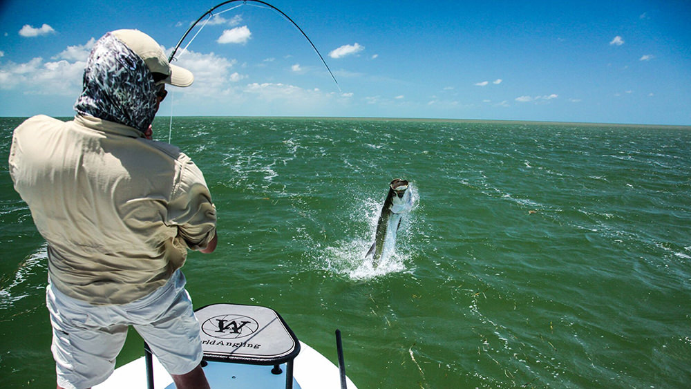
This is a famous fish. If you look back at the old tourism magazines of the early 20th century you will see a lot about tarpon fishing in Florida. As a matter of fact, some say that tarpon fishing was the beginning of the tourism industry in the state. Also known as “silver kings”, they put up a tremendous fight which anglers love, particularly on lighter tackle. It is a sport fish, not sought for food, so catch and release has been the rule for years. But those who seek them will tell you it is worth the fight even if you must release it.
Tarpon have been a popular fishing target for decades.
Photo: NOAA
Tarpon (Megalops atlantica) are large bodied, large scaled fish, with a deep blue back and silver sides. They are a large fish, reaching over 8 feet in length and up to 350 pounds. They tend to travel in schools and are often associated with other fish, such as snook2.
It has always been thought of as a “south Florida fish”. As mentioned, down there it is a popular fishing target for tourist and residents alike. Many charter captains specialize in catching the fish and they have been featured in fishing programs. But you do not hear about such things in the Florida panhandle. Hoese and Moore1, as well as the Florida Museum of Natural History2 both indicate that they are in fact in the Florida panhandle. As a matter of fact, this fish has few barriers and has the distribution of the classic “Carolina fish” group. That includes the entire eastern seaboard of the United States, the entire Gulf of Mexico, and the Caribbean1. The Florida Museum of Natural History indicates they are found on the opposite shores of the Atlantic Ocean and may have made their way through the Panama Canal to the Pacific shores of the canal. Within this range they are known to enter freshwater rivers. They seem to have few biogeographic barriers.
I grew up in the panhandle and remember hearing about them swimming in our area when I was younger. Fishermen said they would throw all sorts of bait at them. Artificial lures, live bait, cut bait, you name it – they tossed it… the tarpon never would take it. Catching one here was almost impossible. The flats fishing charter trips for tarpon in south Florida would not happen here. I remember once diving in Pensacola Bay near Ft. Pickens. We were looking for an old Volkswagen beetle that had been sunk years ago when at one point the water became very dark – almost like storm clouds had rolled in. When my buddy and I both looked up we saw a school of very large fish swimming above us. We were not sure what they were at first but as we slowly ascended, we realized they were tarpon. It was pretty amazing.
An interesting side note here. In 2020 tarpon were once again seen swimming around the Pensacola area but this time they WERE taking bait. There were several reports of tarpon caught off the Pensacola Fishing Pier and inside the bay. Why change over all this time? I am not sure.
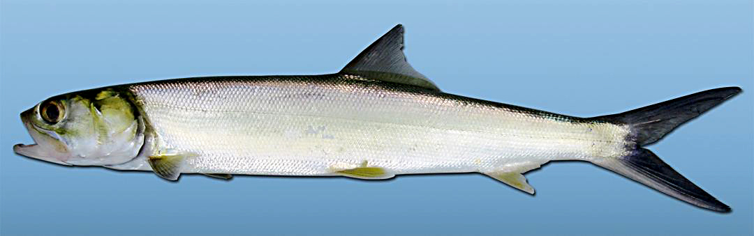
The ladyfish (or skipjack) is the smaller cousin of the tarpon, but puts up a good fight as well.
Photo: University of Southern Mississippi
Tarpon belong to the family Elopidae which also includes another local fish known as the “ladyfish” or “skipjack” (Elops saurus). This is a much smaller fish reaching about 3 feet (and that would be a large ladyfish). The scales of this family member are much smaller, but the fight on hook and line is just as large. The characteristic that places these two fish into the same family (and these are the only two in this family) is the hard bony gular plate found between the right and left side of the lower jaw (in the “throat” area).
Like tarpon, it is not prized as a food fish but more of a game fish. It has the classic wide distribution of the “Carolina fish group” – the eastern seaboard of the United States, the Gulf of Mexico, down to Brazil. Like the tarpon, it is found in brackish conditions but is not mentioned in freshwater. Again, few biogeographic barriers for this fish.
Both members of this family provide anglers young and old with a lot of enjoyment.
1 Hoese, H.D., R.H. Moore. 1977. Fishes of the Gulf of Mexico; Texas, Louisiana, and Adjacent Waters. Texas A&M Press, College Station TX. Pp. 327.
2 Discover Fishes. Tarpon. Florida Museum of Natural History. https://www.floridamuseum.ufl.edu/discover-fish/species-profiles/megalops-atlanticus/.
3 Discover Fishes. Ladyfish. Florida Museum of Natural History. https://www.floridamuseum.ufl.edu/discover-fish/species-profiles/elops-saurus/.