The University of Florida/IFAS Extension & Florida Sea Grant faculty are reintroducing their acclaimed “Panhandle Outdoors LIVE!” series on St. Joseph Bay. This ecosystem is home to some of the richest concentrations of flora and fauna on the Northern Gulf Coast. This area supports an amazing diversity of fish, aquatic invertebrates, turtles and other species of the marsh and pine flatwoods. Come learn about the important roles of ecosystem!
Registration fee is $40. You must pre-register to attend.
Recently I participated in a local festival to educate the public about the Rice’s Whale – the newly described species in the Gulf of Mexico that is now listed as critically endangered, possibly the most endangered whale in the world’s oceans. I honestly did not know enough about it to provide much education and chose to do terrapin conservation at my table instead (something I know more about) but have since learned much about this new member of the Gulf community.
One of the more frequent comments I heard during the event was “I did not know we even had whales in the Gulf”. This is understandable since we rarely see them – most of us have never seen one. When we think of whales we think of colder climates like Alaska, New England, and the colder waters off California. But many large whales must give birth to their smaller calves in warmer waters – so, they make the trek to tropical locations like Hawaii and Florida to do so. But there are also resident whales in the tropical seas.
You first must understand that the term “whale” does not only mean the large creatures of whale hunting fame, but any member of the mammalian order Cetacea. Cetaceans include both the large baleen whales – like the blue, gray, and right whales – but also the toothed whales – like the sperm, orca, and even the dolphins.
The Right whale is another critically endangered whale found in the Gulf of Mexico. Image: NOAA.
There are 28 cetaceans that have been reported from the Gulf, 21 of those routinely inhabit here. Most exist at and beyond the continental shelf – hence we do not see them. Only two frequent the waters over the shelf – the Atlantic Bottlenose Dolphin and the Atlantic Spotted Dolphin, and only one is routinely seen near shore – the Atlantic Bottlenose Dolphin.
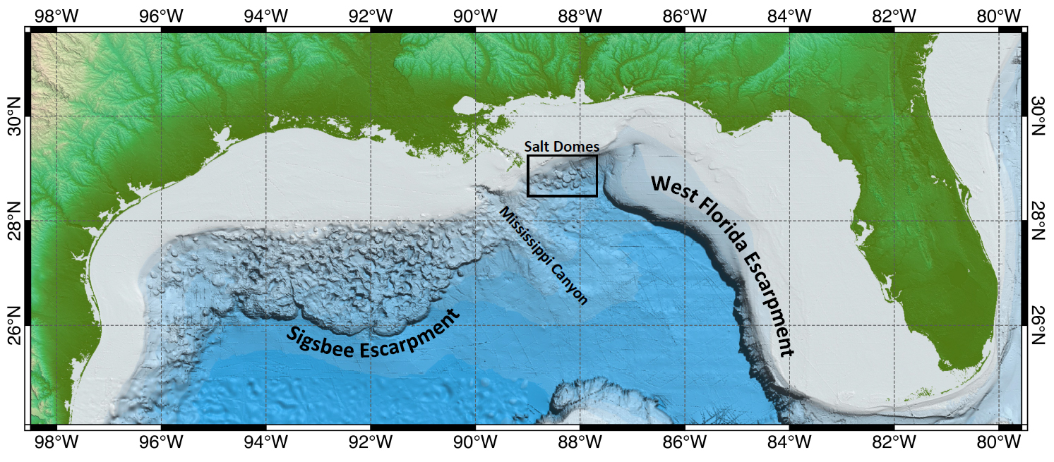
This image shows the location of the continental shelf and thus the location of most of the whales found in the Gulf of Mexico. Image: NOAA.
But offshore, out at the edge of the continental shelf, exists several species of large and small cetaceans. The endangered Sperm, Sei, Fin, Blue, Humpback, and Northern Right whales have been seen. Of those only sperm whales are common. Others include several beaked whales (which resemble dolphins but are much larger), large pods of other species of dolphins, pygmy and dwarf sperm whales, pygmy and false killer whales (as well as the killer whale itself), and other baleen whales such as the Minke and Bryde’s whale.
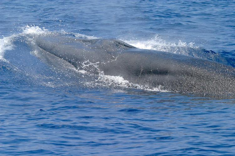
The Bryde’s whale is one of interest to this story.
The Bryde’s whale (pronounced “brood-duss” – Balaenoptera edeni) is a medium sized baleen whale, reaching lengths of about 50 feet and weighing 30 tons. It is often confused with the larger sei whale. They are found in tropical oceans across the planet and are not thought to make the large migrations of many whales due to the fact it is already here in the tropics for birth, and its food source is here as well. They reside in the northeastern Gulf of Mexico extending from the DeSoto Canyon, off the coast of Pensacola, to the shelf edge near Tampa. They appear to travel alone or in small groups of 2-5 animals. They feed on small schooling fish, such as pilchards, anchovies, sardines, and herring. Their reproductive cycle in the Gulf is not well understood.
The Bryde’s whale was thought to be the only resident baleen whale in the Gulf of Mexico. Photo: NOAA.
Strandings have occurred – as of 2009, 33 have been logged. There are no records of mortality due to commercial fishing line entanglement, but vessel strikes have occurred. Due to their large population across the planet, they were not considered for listing under the Endangered Species Act, but that may change in the Gulf region due to human caused mortality. Between 2006-2010 it was estimated that 0.2 Bryde’s whales died annually due the vessel strikes.
In the 1960s Dr. Dale Rice described the Gulf of Mexico population as a possible subspecies. It is the only baleen whale that regularly inhabits the Gulf of Mexico. And ever since that time scientists examining stranded animals thought they may be dealing with a different species.
In the 1990s Dr. Keith Mullin began examining skull differentiation and genetic uniqueness from stranded animals of the Gulf population. Dr. Patricia Rosel and Lynsey Wilcox picked up the torch in 2008. In 2009 a stranded whale, that had died from a vessel strike, was found in Tampa Bay and provided Dr. Rosel more information. In 2019 a stranded whale, that had died from hard plastic in gut in the Everglades, was examined by Dr. Rosel and her team and, with data from this skull, along with past data, determined that it was in fact a different species. The new designation became official in 2019.
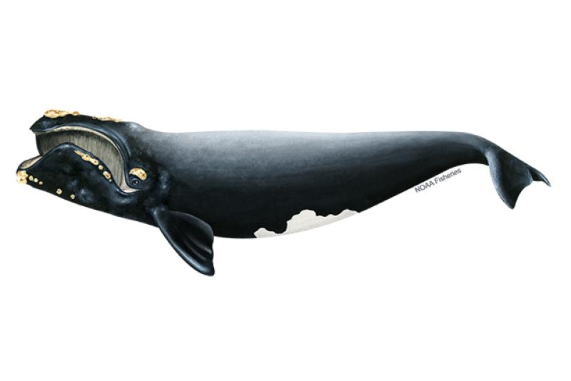
The newly described Rice’s whale only exists in the Gulf of Mexico. Photo: NOAA.
The new whale was named the Rice’s whale (Balaenoptera ricei) after Dr. Dale Rice who had first describe it as a subspecies in the 1960s. With this new designation everything changed for this whale. This new species only lives in the Gulf of Mexico, and it was believed there were only about 50 individuals left. Being a marine mammal, it was already protected by the Marine Mammal Protection Act, but with this small population it was listed as critically endangered and protected by the Endangered Species Act.
New reviews and publications began to come out about the biology and ecology of this new whale. Rice’s whales do exist alone or in small groups and currently move between the 100m and 400m depth line along the continental shelf from Pensacola to Tampa. Diet studies suggest that it may feed near the seafloor, unlike their Bryde’s whale cousins. They may have lived all across the Gulf of Mexico at the 100-400m line at one time. They prefer warmer waters and do not seem to conduct long migrations.
The area where the Rice’s whale currently exists. Image: NOAA.
Being listed under the Endangered Species Act, NOAA National Marine Fisheries (NMFS) was required to develop a recovery plan for the whale. NMFS conducted a series of five virtual workshops between October 18 and November 18 in 2021. Workshop participants included marine scientists, experts, stakeholders, and the public. There were challenges identified from the beginning. Much of the natural history of this new whale was not well understood. Current and historic abundance, current and historic distribution, population structure and dynamics, calving intervals and seasonality, diet and prey species, foraging behavior, essential habitat features, factors effecting health, and human mortality rates all needed more research.
At the end of the workshop the needs and recommendations fell into several categories.
Management recommendations
Create a protected area
Restrict commercial and recreational fishing in such – require ropeless gear
Require VMS system on all commercial and recreational vessels
Require reporting of lost gear and removal of ghost gear
Risk assessment for aquaculture, renewable energy, ship traffic, etc.
Prohibit aquaculture in core area and suspected areas
Reduce burning of fossil fuels
Prohibit wind farms in core area
Renewable energy mitigation – reduce sound, night travel, passive acoustic
Develop spatial tool for energy development and whale habitat use
Require aquaculture to monitor effluent release
Develop rapid response focused on water quality issues
Develop rapid response to stranding events
Reduce/cease new oil/gas leases
Reduce microplastics and stormwater waste discharge
Work with industry to use technologies to reduce noise
Reduce shipping and seismic sound within the core area
Restrict speed of vessels
Maintain 500m distance – require lookouts/observers while in core
Consider “areas to be avoided”
Monitoring recommendations
Long-term spatial monitoring
Long-term prey monitoring
Electronic monitoring of commercial fishing operations
Necropsies for pollution and contaminants
Outreach and Engagement are needed
Top Threats to Rice’s Whale from the workshop Include:
Small population size – vessel collisons
Noise
Environmental pollutants
Prey – Climate change – marine debris
Entanglement – disease – health
Offshore renewable energy development
The Endangered Species Act (ESA) requires the designation of critical habitat for listed species. In July 2023 NOAA proposed the area along the U.S. continental shelf between 100-400 meters depth as critical habitat. Comments on this designation were accepted through October 6, 2023.
The proposed protection zone for the Rice’s whale including the core area. Image: NOAA.
Vessel strikes are a top concern. It is understood that the most effective method of reducing them is to keep vessels and whales apart and reduce vessel speeds within the approved critical habitat.
On May 11, 2021, NOAA Fisheries received a petition submitted by five nongovernmental agencies and one public aquarium to establish a year-round 10-knot vessel speed limit in order the protect the Rice’s whale from vessel collisions. The petition included other vessel mitigation measures. On April 7, 2023, NOAA published a formal notice in the Federal Register initiating a 90-day comment period on this petition request. The comment period closed on July 6, 2023, and they received approximately 75,500 comments. After evaluating comments, and other information submitted, NOAA denied the petition on October 27, 2023.
NOAA concluded that fundamental conservation tasks, including finalizing the critical habitat designation, drafting a species recovery plan, and conducting a quantitative vessel risk assessment, are all needed before we consider vessel regulations. NOAA does support an education and outreach effort that would encourage voluntary protection measures before regulatory ones are developed.
On that note, the Bureau of Ocean Energy Management (BOEM) did issue voluntary precautionary measures the industry could adopt to help protect the Rice’s whale. These include:
Training observers to reduce vessel collisions.
Documenting and recording all transits for a three-year period.
All vessels engaged in oil and gas, regardless of size, maintain no more than 10 knots and avoid the core area after dusk and before dawn.
Maintain 500m (1700 feet) distance from all Rice’s whales.
Use automatic identification system on all vessels 65’ or larger engaged in oil and gas.
These suggestions would not apply if the crew/vessel are at safety risk.
So…
This is where the story is at the moment…
This is what is up with the Rice’s whale in the Gulf of Mexico.
2 Rosel, P.E., Mullin, K.D. Cetacean Species in the Gulf of Mexico. DWH NRDA Marine Mammal Technical Working Group Report. National Marine Fisheries Service. Southeast Fisheries Science Center.
7BOEM Issues Voluntary Precautionary Measures for Rice’s Whale in the Gulf of Mexico. 2023. U.S. Department of Interior. Bureau of Ocean Energy Management.
8NOAA Fisheries Denies Petition to Establish a Mandatory Speed Limit and Other Vessel Mitigation Measures to Protect Endangered Rice’s Whales in the Gulf of Mexico. NOAA Fisheries News. FB23-079. Gulf of Mexico Fishery Bulletin. October 27, 2023.
Organized and sponsored by Florida Sea Grant, the “Stem to Stern” workshop in November 2023 at the Emerald Coast Convention Center marked a significant gathering in marine conservation and management. This event drew together legal experts, representatives from the Florida Fish and Wildlife Conservation Commission (FWC), local marine resource coordinators, law enforcement, and industry stakeholders to tackle critical issues facing Florida’s marine environments. Through discussions that ranged from legal frameworks for boating and waterway access to environmental conservation strategies, the workshop facilitated a deep dive into the complexities of marine policy and stewardship. Discover new programs, insights, and collective expertise shared at “Stem to Stern.”
Florida Sea Grant Boating and Waterways Workshop
November 2, 2023 Emerald Coast Convention Center
1250 Miracle Strip Parkway SE – Ft. Walton Beach FL
9:00 – 9:25 WELCOME AND INTRODUCTIONS
Welcome
Rick O’Connor (Florida Sea Grant UF IFAS Extension)
Moderators –Mike Norberg and Jessica Valek (Okaloosa County)
3:15 – 3:45 WRAP UP – Robert Turpin (Escambia County Marine Resources)
PROGRAM SPONSORS
Acknowledgement
We extend our deepest gratitude to all who contributed to the success of the “Stem to Stern” workshop. To our esteemed speakers, whose expertise and insights into marine conservation and management have been invaluable, we offer our sincere thanks. Your presentations were not only informative but also inspirational, guiding us toward a more sustainable future for our waterways.
A special acknowledgment goes to the members of the planning and program committee. Your dedication and hard work in organizing this event did not go unnoticed. From the initial planning stages to the execution of the workshop, your efforts have been the backbone of this successful gathering.
We also want to thank the authors of the surveys that have provided us with essential data and perspectives. Your research and analysis contribute significantly to our understanding of the challenges and opportunities within Florida boating and waterways.
Lastly, we are incredibly grateful for the support from our sponsors. Your generosity and commitment to Florida Sea Grant and marine conservation have been crucial in bringing this workshop to life. Your support not only made this event possible but also highlights your dedication to safeguarding our marine ecosystems.
Together, we have taken an important step towards protecting and enhancing Florida’s waterways. Thank you for your contributions, commitment, and shared vision for a sustainable future.
Information edited and compiled by: L. Scott Jackson, Chantille Weber, and Amon Philyaw, UF/IFAS Extension Bay County
An Equal Opportunity Institution. UF/IFAS Extension, University of Florida, Institute of Food and Agricultural Sciences, Andra Johnson, Dean. Single copies of UF/IFAS Extension publications (excluding 4-H and youth publications) are available free to Florida residents from county UF/IFAS Extension offices.
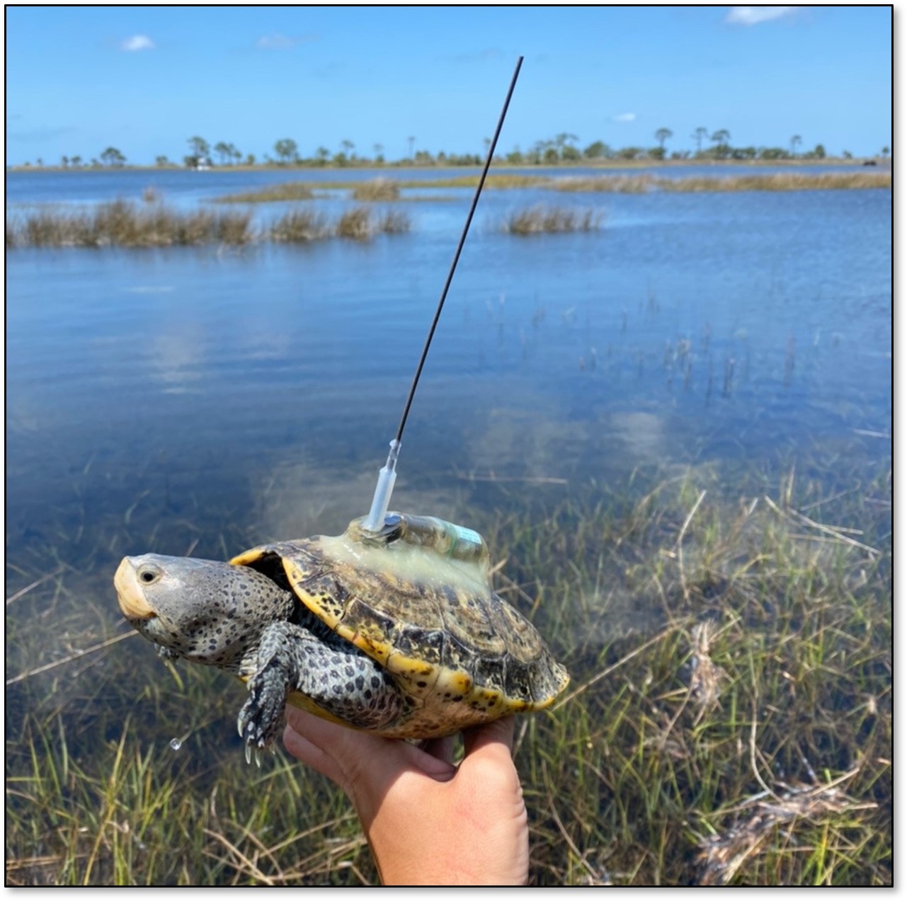
Recently I attended a workshop on wildlife tagging projects. Researchers from across the Gulf of Mexico who had projects going on in the northern Gulf were invited to present their updates. I was there to help present what we have learned about diamondback terrapins but there were numerous other talks, and the results were fascinating. Fascinating enough that I thought the public would be interested in them as well. Most of the presentations were on fish or reptiles, but the fish included interesting species such as whale sharks, tiger sharks, cobia, and tarpon. So, I am going to run a series of posts on the different species along with another series on barrier island wildlife.
I thought I would start with an introduction on the methods of wildlife tagging and why scientists tag animals. Some of the reasons may seem obvious, but with today’s modern tags, there is a lot of information scientists can gain from doing this.
Why do they tag?
With the types of tags they used when I was in school there were a few things that you could learn. (1) How far do the animals range, (2) how fast they reached those locations, (3) some idea of live longevity – you at least knew how long they were “at freedom”. With these data you could get a better idea of what their habitat range was and how they used the habitat. Some, like blue sharks, may move great distances all year long. Others, like nurse sharks, may not move more than a few miles from the point where they were tagged. Others may move seasonally, spending summer in one region and winter in another. All of these data are useful to resource managers responsible for maintaining the species population.
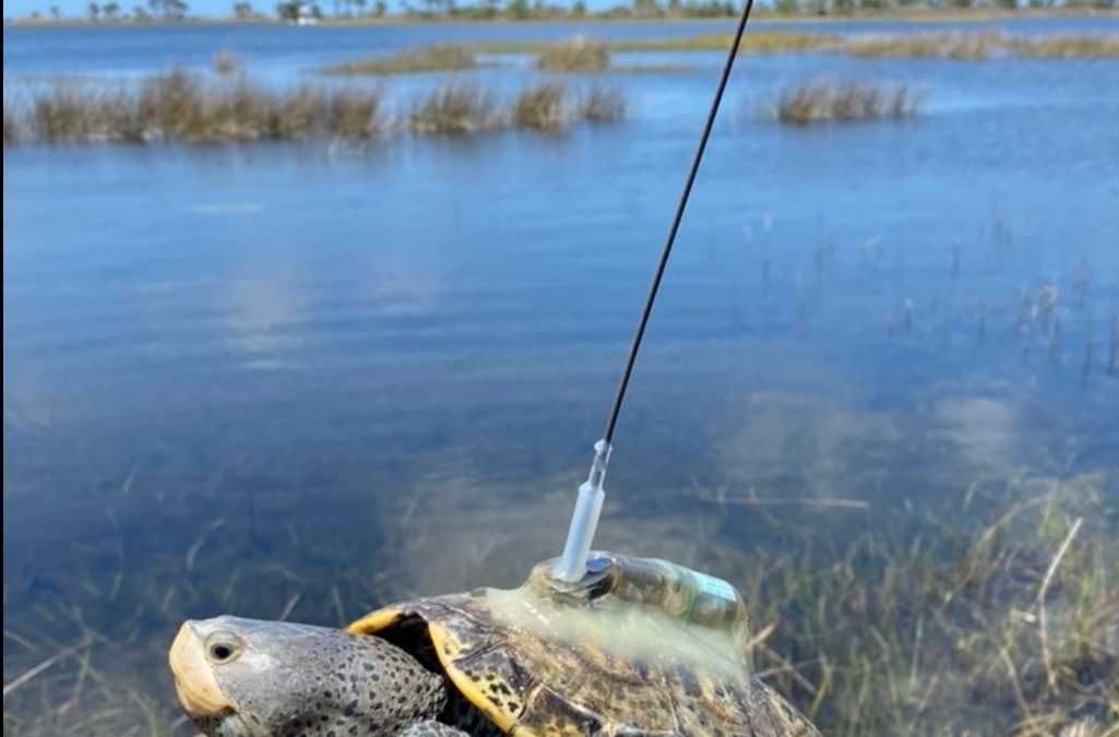
With the more modern electronic tags, they can learn such things as how deep they dive, how long they stay at depth, what water temperatures they may frequent, what salinity they prefer, and let you know where the animal is at any given moment in time. Today’s tags are pretty amazing.
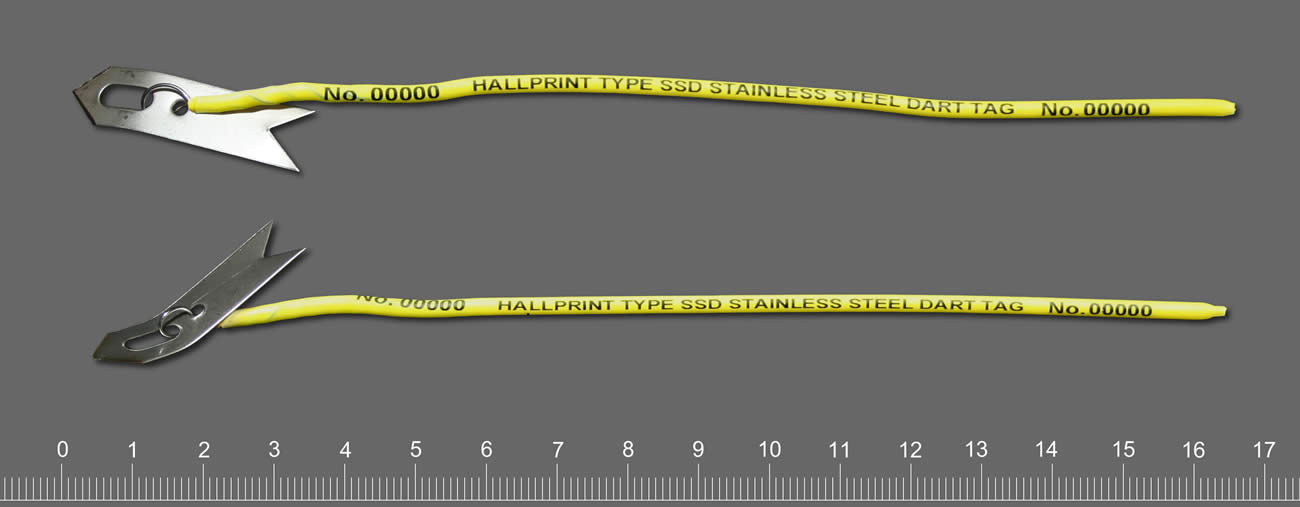
This tag is similar to the ones we used in the 1980s on sharks. They provide a number for individual identification. Ours also had a capsule with a note on water resistant paper.
Photo: Hallprint.
How do they tag?
Well… step one to answering this question is HOW DO YOU CATCH THE ANIMAL? – not as easy as you think. Whale sharks and leatherback sea turtles are quite a handful. If your target species is something like a white shark, tiger shark, diamondback rattlesnake, there is an extra danger added. As you plan a method for your safety, you must also plan a method for their safety. The objective is not harm or kill the creature – you will learn nothing from this. When I began my career, I saw a program on how they tagged polar bears in the 1980s. They would fly over the ice in a helicopter looking for the bears. When the bears saw the helicopter, they would run for the safety of water. The scientist would try to shoot a dart into the animal to put it asleep long enough to get a tag on it. BUT if you overdosed the bear, and it made it to the water, it could drown. So, from the air, they had to gauge the weight of the bear, guess what amount of the drug to shoot, and hope they were right. If the bear did fall asleep, how “asleep was it? Did you give ENOUGH drug? Polar bears can be very dangerous. In the episode I watched the bear was asleep, but the researchers did mention that they will “play sleep” and you need to be ready. Such was the world of wildlife tagging 40 years ago.
One of the things that was also discussed when I was in school was what type of tag you were going to place on the animal. They did not have the neat tools they have now. Most tags had a capsule with a piece of paper, sometimes written in multiple languages, to call said person and report where and when they found the animal. There was usually a monetary award for doing so, or sometimes a hat or T-shirt. I remember the hat you got for reporting a tagged redfish was really neat, but I never caught a tagged one.
You did not want to place a tag that would alter the natural behavior of the animal. In the case of the polar bear, they would place an ear tag and paint a large number on its side in black paint. This made sense from the biologist’s side – flying over the ice you could see the large black “3” on a bear and know the individual. But that large black number could also be seen by their prey. Not good. I saw researchers painting the shells of gopher tortoises with all sorts of neon colors to make detection by them easier, but easier for their predators as well.
Radio tagging was used 40 years ago. This involves capturing the animal (as we have already seen – fun in itself), putting it asleep and attaching/inserting a radio tag. This tag provides a radio signal that can be detected by a receiver carried by the research holding an antenna walking/driving around following the animal. You had to be within range to hear the signal and – honestly – good at detecting the signal. Some researchers were better at this than others. As you can imagine this was only as good as your ability to keep up with the animal. At some point your car/boat would need fuel, or the animal crossed a river you could not. It provided some good data, but there were limits.
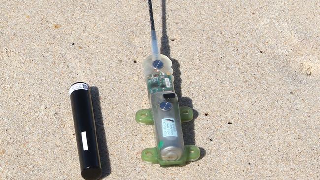
Today modern tags have solved a lot of these issues. Some new tags do not have typed notes but sensors that can detect the elevation/depth, temperature/salinity, all sorts of information that was unknown in my college days. These tags can be retrieved and downloaded on a computer to give a much better idea of how the animal spends its time and what it seeks.
This modern shark tag could provide additional information such as diving depth, water temperature, and more.
Satellite tags work well for creatures who surface frequently – sea turtles, whales, whale sharks. Satellites can detect them, and you can follow their movements/habitat preferences as they are actually using them.
For species at depth, like some sharks, cobia, tarpon, etc. there are now acoustic tags. The tag emits a signal that is detected by an array of receivers the researchers place in the environment. As the animal passes within range of the receiver it is detected, and the downloaded data gives a similar picture of how the animal uses the environment. A couple of neat things about acoustic tags are that (a) you can track satellite tagged animals while they are diving, and (b) your receivers can detect other species tagged by other researchers and let them know where their creature was. This was one reason for the workshop – so, everyone could meet everyone else and know who has tagged what and how to share information.
No tag is permanent. All are designed to fall off. Battery power will eventually fail. But no animal is stuck with this all of their lives as they could have been when I was in school. In future articles we will look at the results of some of these studies.
This tag with an antenna can be detected by a satellite and tracked real time.
Photo: USGS
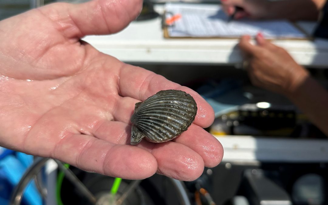
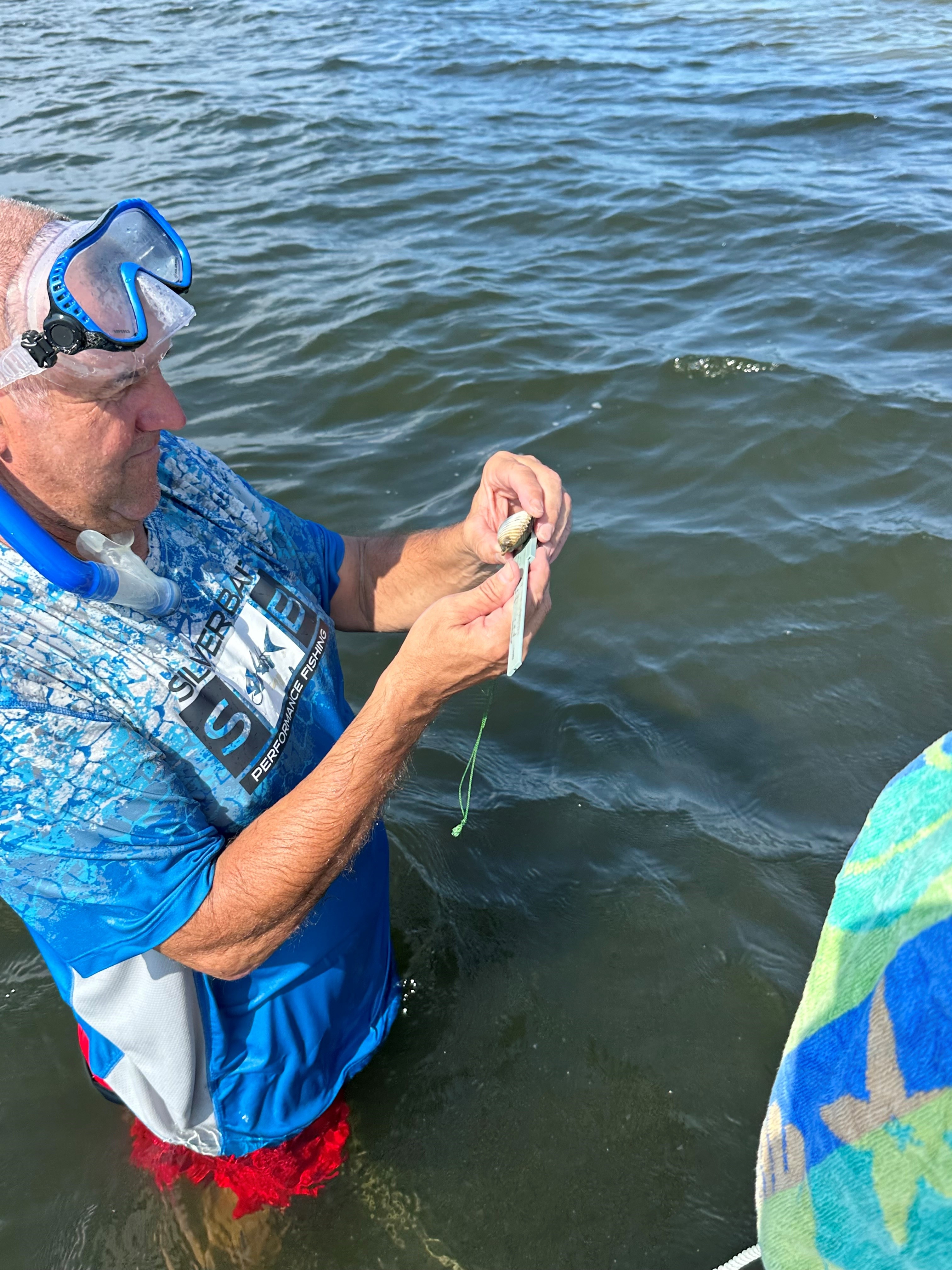
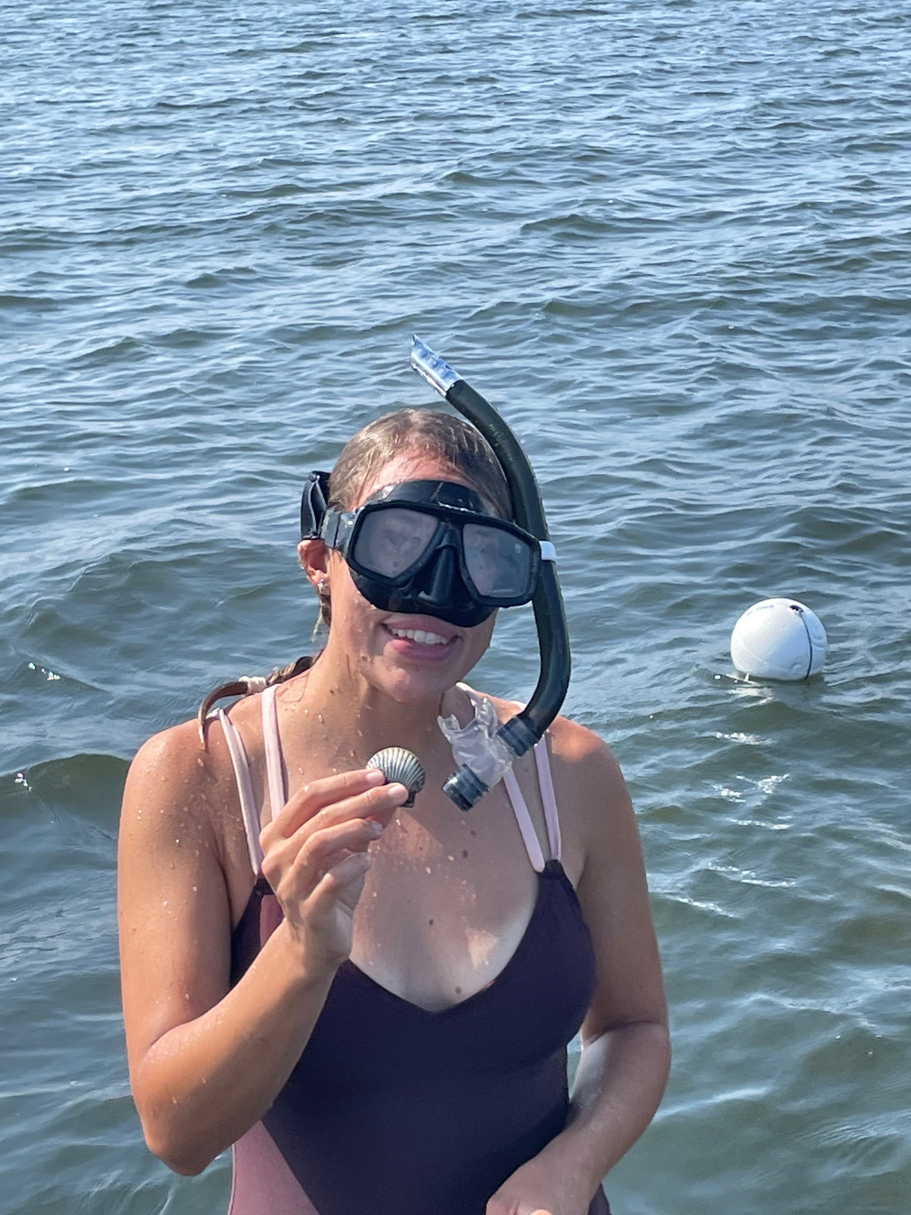
Bay scallops (Argopecten irradians) have been an important part of the economy of many gulf coast communities within the Florida Big Bend for decades. It was once abundant in all gulf coast counties of the state but beginning in the 1960s populations in many bays began to decline to levels where they are all but nonexistent. The cause of this decline has been associated with many factors including a decline in water quality, a decline in suitable habitat (sea turtle grass beds – Thalassia), and overharvesting. Most likely the cause included all of these. Since the collapse of both the commercial and recreational fishery, Gulf coast communities have been trying to address all three of the stressors above. Multiple monitoring projects are ongoing in the Pensacola Bay area and one of those is the Great Scallop Search.
The Great Scallop Search was developed by Sea Grant Agents in Southwest Florida and expanded, through Florida Sea Grant, to Northwest Florida. In each location volunteers snorkel a 50-meter transect line searching for live bay scallops, as well as monitoring the status of the seagrass habitat. Since 2015 317 volunteers have logged 634 hours surveying 407 50-meter transects in 106 grids in Big Lagoon or Santa Rosa Sound. In that time 4 live scallops have been logged, though we hear anecdotal reports of additional scallops being found in these bodies of water.
Survey Method
Volunteers select and survey one of 11 grids in Big Lagoon, or one of 55 grids in Santa Rosa Sound. Once on site, the volunteers anchor and record preliminary information on the data sheet provided. Two snorkelers enter the water and swim on opposite sides of a 50-meter transect line searching for live scallops. Any live scallop found is measured and returned. The species and density of the seagrass is recorded as well as the presence/absence of macroalgae on that seagrass. Four such transects are surveyed in each grid.
2023 Results
2023
SRS
BL
Total
Other
# of volunteers
72
No significant difference between 2022 and 2023
# of grids surveyed
8
8
16
Slight decrease from 2022. 16 of the 66 grids (24%) were surveyed.
# of transects surveyed
26
51
77
A decrease from 2022. More surveys were conducted in Big Lagoon than Santa Rosa Sound.
Area surveyed (m2)
2600
5100
7700
1.9 acres
# of scallop found
2
2
4
Four live scallops are a record for this project. It equals the sum of all other live scallops since the project began.
Scallop Size (cm)
4.5, 5.0
4.0, 4.5
Surveys with Seagrass
Halodule
5
12
17
17/21 surveys – 81%
Thalassia
8
11
19
19/21 surveys – 90%
Syringodium
0
2
2
2/21 surveys – 10%
Grass Density
100% grass
3
9
12
12/21 surveys (57%) were 100% grass
90%
1
0
1
Note: Volunteers typically select area for transects
75%
3
1
4
with a lot of grass.
70%
1
0
1
50%
3
9
12
5%
1
0
1
Macroalgae
Present
4
4
8
Absent
2
10
12
12/21 surveys (57%) had no macroalgae.
Abundant
2
2
4
Sediment Type
Mud
0
1
1
Sand
7
8
15
15/21 surveys (71%) were sandy.
Mixed
1
4
5
21 surveys were conducted covering 16 grids. 8 grids were surveyed in each body of water.
A total of 77 transects were conducted covering 7,700 m2 and four live scallops were found.
Two of the scallops were found in Big Lagoon and two in Santa Rosa Sound.
All scallops measured between 4-5cm (1.6-2”).
The number of live scallops found this year equaled the total number found over the last eight years.
Most of the transects included a mix of Halodule and Thalassia seagrass ranging from 100% coverage to 5%. The majority of the transects were between 50-100% grass. Four transects had 100% Thalassia. Three of those were in Santa Rosa Sound, one was in Big Lagoon. The diving depth of the volunteers ranged from 0 meters (0 feet) to 2.4 meters (8 feet). Macroalgae was present in 8 of the 21 surveys (38%) but was not abundant in most.
Volunteer measuring one of the four collected bay scallops in 2023 from Pensacola Bay.
Photo: Gina Hertz.
Summary of Project
Year
Volunteer
Grids Surveyed
Transects Surveyed
Live Scallops Found
2015
87
28
101
0
2016
96
31
111
1
2017
5
4
16
0
2018
20
7
32
0
2019
13
6
20
0
2020
5
2
16
1
2021
17
6
24
0
2022
74
22
87
2
2023
72
16
77
4
TOTAL
317
407
8
MEAN
35
14
45
0.4
To date we are averaging 35 volunteers each event, surveying 14 of the 55 possible grids (25%). We are averaging 45 transects each year (4500 m2), have logged 407 transects (40,700 m2) and have recorded 8 live scallops (< than one a year).
Discussion
Based on the results since 2016 this year was a record year for live scallops. Whether they are coming back on their own is still to be seen. Being mass spawners, bay scallop need high densities in order to reproduce successfully, and these numbers do not support that. The data, and comments from volunteers, suggest that the grasses look good and dense. Thalassia, a favorite of the bay scallop, appear to be becoming more abundant. This is a good sign.
Though small and few, bay scallops are trying to hold on in Pensacola Bay.
Photo: Gina Hertz
The Gulf of Mexico Sea Grant Science Outreach Team is proud to announce four new outreach items that are applicable throughout the US and showcases marine microplastics and homeowners’ insurance:
Marine Microplastics Primer for Extension Professionals – This publication is intended to serve as a guide for extension professionals to aid in answering questions about microplastics that they have encountered or may encounter in the future. The publication can be accessed at https://gulfseagrant.org/wp-content/uploads/2023/08/MASGP-23-051.pdf.
Property Insurance Basics – Confused about homeowners’ insurance and what it covers or know people who are? The outreach team has created a publication to share basic information about insurance to help property owners make informed decisions about the amounts and types of protection for their homes. Access to the publication can be found https://gulfseagrant.org/wp-content/uploads/2023/08/MASGP-23-015.pdf.
What is Risk Rating 2.0 and how will it affect my flood insurance?–FEMA has updated their risk rating approach through a new pricing method. This change is the biggest change to the way flood insurance premiums are calculated since 1968. Want to learn more about this new system and how it will affect your flood insurance? Click https://gulfseagrant.org/wp-content/uploads/2023/08/What-is-Risk-Rating-2.0.pdf to access our publication.