by Rick O'Connor | Aug 8, 2021
Like the ancient sturgeon, this is one strange prehistoric looking group of fish. I’ll say group of fish because there is more than one kind. For many, all gars are alligator gars. There is an alligator gar but there are others. Actually, the longnose gar may be seen more often than the alligator gar, but many do not know there is more than one kind.
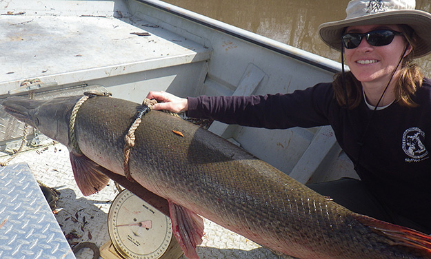
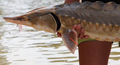
Gars are freshwater fish, but several species have a high tolerance for saltwater. The alligator gar (Artactosteus spatula) has been reported from the Gulf of Mexico1. They are elongated, slow moving fish with extended snouts full of sharp teeth – very intimidating to look at. But swimming with gars in springs and rivers, I have found them to be oblivious to me. Snag one in a net however, and they will turn quickly and could do serious harm. While fishing my grandson had one come after his bait once and that was pretty exciting, but it is rare to catch them on hook and line. Many who fish for them do so with bow and arrow. Their skin is covered with tough ganoid scales. You really can’t scale them; you have to skin them.
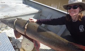
Alligator Gar from the Escambia River.
Photo: North Escambia.com
In the book Fishes of the Gulf of Mexico, by Hoese and Moore, they list four species of gar in the northern Gulf. As the name suggests, the longnose gar (Lepisosteus osseus) has a long slender snout and has spots on the body. It is the one most often seen by people visiting our springs, rivers, and the one most often seen in our estuaries. It can reach a length of five feet3.
The famous alligator gar (Artactosteus spatula) has a shorter snout and spots are usually lacking. If they do have them, the are usually on the fins. This is a big boy – reaching lengths of nine feet and up to 100 pounds2. They are common in coastal estuaries and even the Gulf, though not encountered very often.
The spotted gar (L. oculatus) also has a short snout but has spots all over its body. It prefers the rivers and will enter estuaries only where the salinities are low. It is smaller at four feet4.
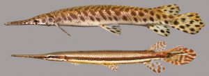
Spotted Gar.
Photo: University of Florida
The last panhandle gar is the shortnose gar (L. platostomus). This species too prefers rivers and may enter low salinity bays. It has a short snout and lacks spots.
There is a Florida gar (L. platyrhincus) not found in the panhandle but exists along the central and south Florida gulf coast. It seems to have replaced the spotted gar in this location5.
The biogeography of this group of fish is interesting in that it is an ancient like the sturgeon, it existed during a time period when much of Florida would have been underwater. The general range of gars is the entire eastern United States. They prefer slow moving rivers, or backwaters of faster rivers, and are common in springs. As mentioned, a few species will venture into saltwater and can be found around the Gulf of Mexico. But with several species there has obviously been some speciation over time.
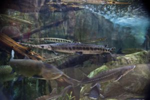
The common longnose gar.
Photo: University of South Florida.
The longnose gars have one of the widest distributions within the group. They are found in most river systems across the eastern United States and all of Florida. It seems to have few barriers including saltwater.
Alligator gars have a similar distribution but seem to be restricted from the peninsula part of Florida. The Florida rivers where they are found are all in the panhandle and are all alluvial rivers – muddy and not tannic like the Suwannee. This could be due to required food that prefer alluvial rivers, pH (pH is lower in the tannic rivers), or something else. Though they did not disperse into central and south Florida, they did extend their range westward down into Mexico. And, as mentioned, have been reported in the open Gulf of Mexico.
Spotted gars follow a similar distribution to the alligator gar. Much of the Mississippi River basin, Florida panhandle, and west to Texas – but they are not found in peninsular Florida. Pre-dating the emergence of peninsular Florida from the sea, there was some barrier that prevented them from dispersing south when the landmass did appear.
A different species appeared in peninsular Florida along with the longnose gar – the Florida gar. It is found in central and south Florida and has dispersed a little north along the Atlantic coast to Georgia.
This is an interesting group of ancient fish. Some are commercially harvested and have suffered from human alterations of river systems. They are amazing to see.
1 Hoese, H.D., R.H. Moore. 1977. Fishes of the Gulf of Mexico; Texas, Louisiana, and Adjacent Waters. Texas A&M Press, College Station TX. Pp. 327.
2 Discover Fishes. Florida Museum of Natural History. Alligator Gar. https://www.floridamuseum.ufl.edu/discover-fish/florida-fishes-gallery/alligator-gar/.
3 Discover Fishes. Florida Museum of Natural History. Longnose Gar. https://www.floridamuseum.ufl.edu/discover-fish/florida-fishes-gallery/longnose-gar/.
4 Discover Fishes. Florida Museum of Natural History. Spotted Gar. https://www.floridamuseum.ufl.edu/discover-fish/florida-fishes-gallery/spotted-gar/.
5 Discover Fishes. Florida Museum of Natural History. Florida Gar. https://www.floridamuseum.ufl.edu/discover-fish/florida-fishes-gallery/florida-gar/.
by Erik Lovestrand | Jul 9, 2021
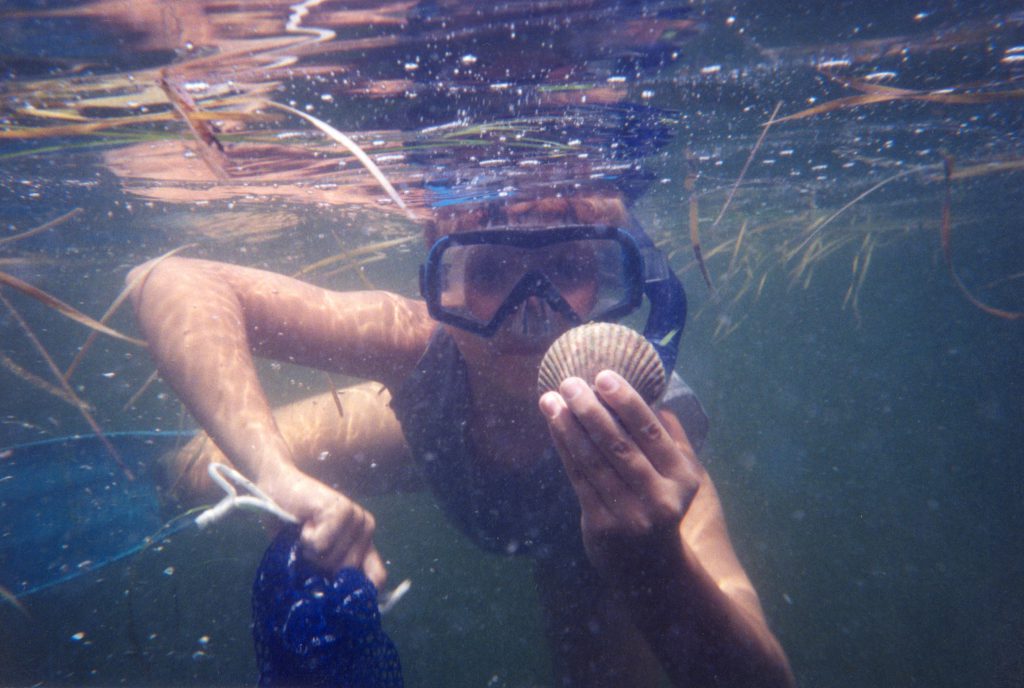
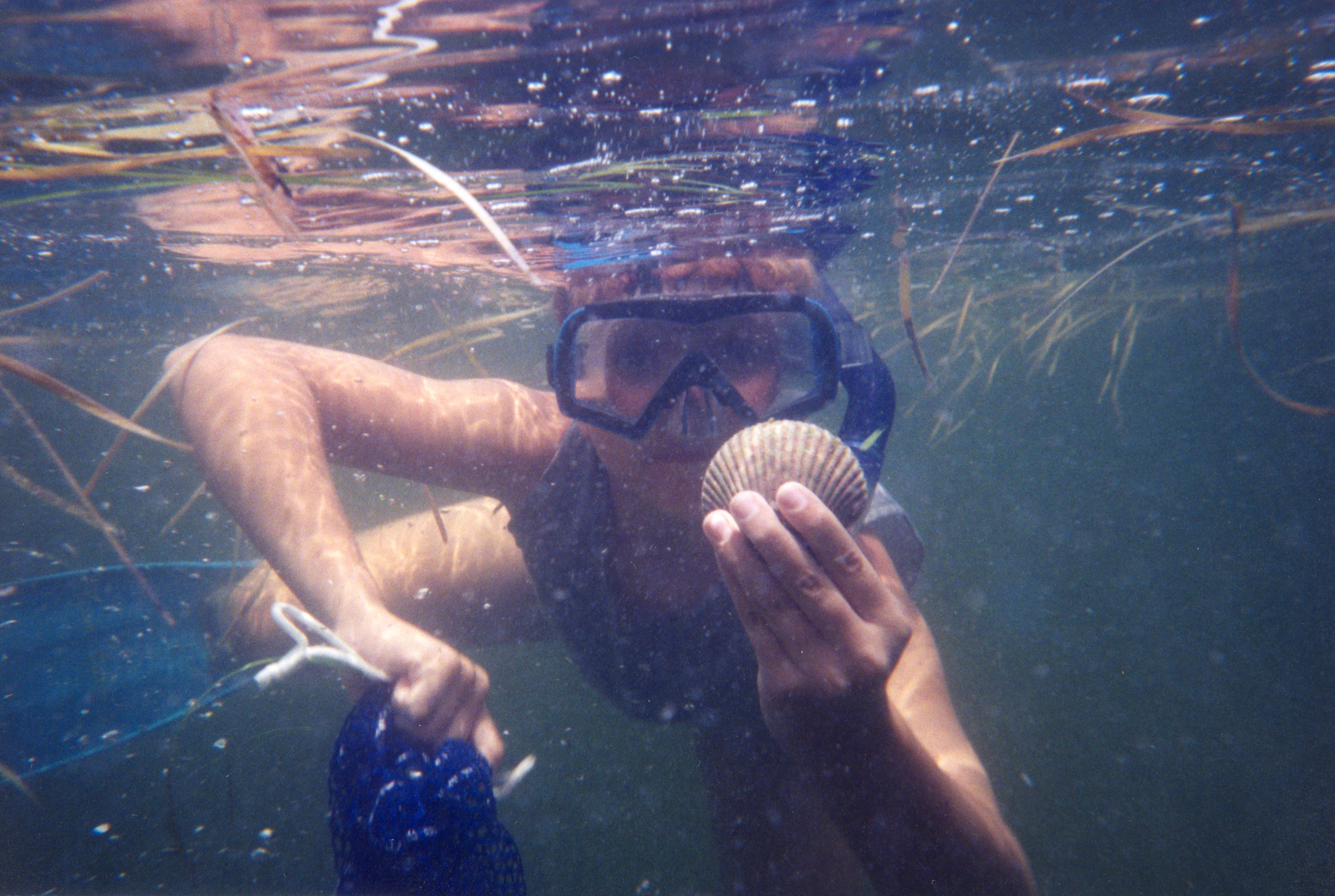
Summertime in North Florida is an awesome time of year if you like to harvest and prepare your own seafood from local waters. In my area, around Wakulla and Franklin County, scallop season runs from July 1 – September 24. In St. Joseph Bay, another popular scalloping area in Gulf County, the season spans from August 14 – September 24. Therefore, in the spirit of “sharing the love,” here is my recipe for a day with family and friends that you will never forget and will eagerly anticipate repeating each year as summertime approaches.
Two parts: “local knowledge”
– Study boating access points and local water depths/tides
– Talk to locals about the best places to find scallops
– Ask others for their favorite scallop recipes
One part: “the right gear”
– Masks, snorkels and mesh bags are a must
– Dive fins and small dip nets are helpful
– Dive flag on display is required when swimming
– Bring a bucket for measuring your catch
One part: “a little luck”
– Sunny days and clear water are best for seeing scallops down in the seagrasses
– Winds below 10 knots make boating and snorkeling more pleasant
Two parts: “paying attention to the details”
– Know the rules on Licenses, gear, limits and season dates
– Conduct equipment checks on snorkel gear, boat/trailer, and required safety gear
– Boat safely and cautiously near swimmers and over shallow seagrass beds
– Keep young children close, watch the weather, and know local hazards for boaters
– Don’t forget the sunscreen, snacks, and adequate hydration for all
A healthy pinch: of “enthusiasm,” with a helping attitude for first-timers
– From the first one you spot nestled down in the seagrass, to the last one of the day, you will never tire of the thrill
– Reassure first-timers that the seagrass is a fascinating environment, not a scary place, by showing them its wonders (i.e. sea stars, burrfish, spider crabs, and much, much more)
– Teach proper shucking technique with a curved blade to avoid wasted meat
Yield: A full day of memories and an incredible culinary experience.
– A limit of scallops is two gallons (in the shell) per person currently, with no more than 10 gal per boat. Ten gallons of scallops in the shell will allow you to fix a feast of scallops, prepared several ways. We like to marinate some in Italian dressing then grill on skewers, sauté a batch with garlic and butter, and deep fry some with a light breading. Throw in a fresh batch of cole slaw, some hush puppies and laughter around the table to top it off and your day will have been a true success. Oh, I will also say that you will be thoroughly exhausted and will probably get one of your best nights of sleep since last summer’s scallop season.
by Rick O'Connor | Jul 9, 2021
This is one strange, primitive, dinosaur-looking fish. They have large scutes embedded in their skin that give them an armored look. They are big – reaching 14 feet in length and 800 pounds (though the Gulf sturgeon does not reach the large size of their cousin the Atlantic sturgeon). They resemble sharks with their heterocercal caudal fin and possess long whiskers (barbels) suggesting a benthic mode of feeding.

Sturgeon are large fish. The barbels (whiskers) are for finding prey buried in the sediment. Notice the raised ganoid scales of this ancient creature.
Photo: U.S. Fish and Wildlife Service.
Panhandle residents know them from their impressive leaps as they head upriver for spawning in the spring. The loud splash from one of these leaps can be heard for a long distance and is a concern for boaters who may be zipping up and down one of the local rivers on a jet sky, or even a bass boat. When in college, we asked one of the professors – “why do mullet jump?”. He paused for a second and responded – “for the same reason manta rays jump”. There was another longer pause. Understanding what was going on we took the bait and asked – “okay… why do manta rays jump?” – “we don’t know”. However, that was in 1980 and a lot has been learned since. We know that not only do mullet and mantas leap, but baleen whales and sturgeon do as well. It is believed that baleen whales leap to communicate during the breeding season. Since sturgeon breed in panhandle rivers, it is believed that this is the reason they may do so. Scientists have also found it helps adjust their swim bladders with internal gas making them more buoyant in the water.
Like salmon, sturgeon swim up rivers to breed and spawn in the spring. Fertilization is external and the gray-black eggs are laid on the substrate at the bottom. The newborn and adults spend the remaining spring in the rivers, and the adults do not feed at this time. In summer all head for the estuaries where the adults begin feeding with a vengeance. They feed on a variety of benthic invertebrates and prefer sections of the bay that are well oxygenated. Sturgeon spend the summer and much of the fall in the bays until the temperatures begins to drop at which time they head into the open Gulf of Mexico. The spring, they find their breeding rivers and the reproductive cycle begins again. This is a long-lived fish, reaching up to 50 years in age.
As far as the biogeography of this species, it is an interesting one. They have been around for about 200 million years. This was about the time the whole “Pangea” movement was going on – Florida did not look like Florida then. There was an opening between what is now the southeastern United States and the Florida peninsula. The water moving through this was called the Georgia Seaway or the Suwannee Channel. This allowed marine species to easily move from the Atlantic to the Gulf of Mexico. It was believed the current in this seaway was significant enough to keep silt and clays from reaching what would be become peninsula Florida, which was probably a submerged region of islands at the time.
During those times the Atlantic sturgeon (Acipenser oxyrinchus) inhabited this region, using southeast rivers for breeding. About 25 million years ago global land mass changes began a period of ice formation that encouraged sea level to drop and the peninsula portion of Florida was exposed – the Florida people know today. However, this new peninsula isolated populations of sturgeon (and other fish at that time) from reaching each other. As time moved on, different genetic changes occurred in both populations to produce offspring that varied from each other. These external morphological changes were enough to let you know they were different, but genetically they are close enough to still breed. In these situations, they have deemed “subspecies” of each other. The Atlantic sturgeon (Acipenser oxyrinchus oxyrinchus) and the Gulf sturgeon (Acipenser oxyrinchus desotoi). It is the Gulf sturgeon we find along the panhandle. This process of producing new subspecies and species due to population isolation over time is called speciation.
Another interesting trend is the original range of the Gulf sturgeon was from the Texas/Louisiana border to about Tampa Bay. This suggest that the fish took advantage of numerous rivers for breeding but there was a barrier as you reach the tropics. Whether that barrier was climatic (temperature) biological (food source) or something else I am not sure. With the high concentration of sturgeon in the panhandle you might think they require the alluvial rivers of this region. But sturgeon are as common in tannic rivers, such as the Suwannee and Yellow Rivers, as they are in those alluvial ones, such as the Escambia and Apalachicola.
Today, their range is even smaller. They are now found only in the rivers between Louisiana/Mississippi border to the Suwannee River. This range reduction is probably due to habitat alteration (much of it human induced – such as dams) and overharvesting (the eggs of the sturgeon are used for caviar). Today all species and subspecies of sturgeon are protected by the endangered species act.
Because this is an ancient fish, the biogeographic story of the sturgeon is an interesting one and shows how speciation occurs over time with all life. They are really cool fish and, if you have not seen one leap yet, I hope you get to. It is pretty amazing.
References
Florida’s Geologic History, University of Florida IFAS, https://edis.ifas.ufl.edu/publication/UW208.
NOAA Species Directory, Gulf Sturgeon, https://www.fisheries.noaa.gov/species/gulf-sturgeon.
NOAA Species Directory, Atlantic Sturgeon, https://www.fisheries.noaa.gov/species/atlantic-sturgeon.
Sturgeon, Florida Fish and Wildlife Conservation Commission, https://myfwc.com/conservation/you-conserve/wildlife/sturgeon/#:~:text=When%20the%20ambient%20pressure%20changes,to%20communicate%20with%20other%20sturgeon..
by Laura Tiu | Jun 23, 2021
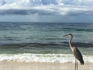
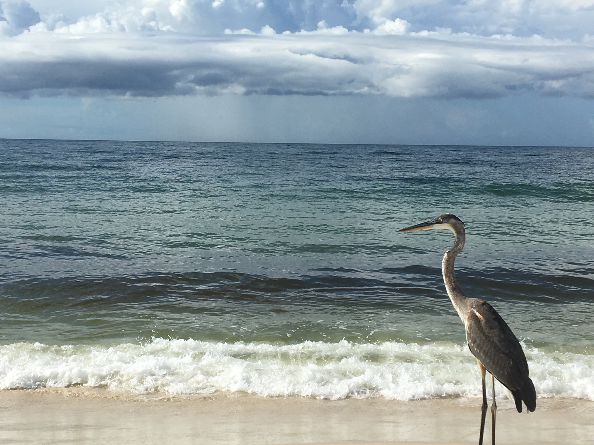
A great blue heron enjoying the Gulf of Mexico.
Photo: Chris Verlinde
June is National Ocean Month. Close your eyes and think about just how many oceans there are. Surprise, there is only one! The ocean is huge, covering over 70 percent of the earth’s surface. Traditionally, the ocean was divided into four named ocean basins: the Pacific, Atlantic, Indian, and Arctic. However, most countries, including the United States, now recognize the Southern (Antarctic) as the fifth ocean. No matter where you live, you are connected to our one global ocean.
What do you know about our ocean? The ocean is where life began over 3.5 billion years ago. The ocean covers over 70% of the Earth’s surface and includes over 96% of the Earth’s water. Australia’s Great Barrier Reef is the largest living structure on Earth and can be seen from the moon! The deepest part of the ocean is in the Mariana Trench, and nearly 7 miles beneath the waves! Coral reefs cover only 1/50th of the ocean floor but about one quarter of all the marine species make coral reefs their home. No light penetrates the ocean at depths greater than 3,280 feet. Aided by deep diving rovers and remote sensing cameras, scientists are still discovering new species beneath the waves. The Gulf Stream transports more water than all the Earth’s rivers combined. The mid-ocean ridge crisscrosses the globe for over 40,000 miles and is the largest geological feature on Earth. Did you know that about 95% of the ocean remains unexplored?
What about our beloved Gulf of Mexico? Is it an ocean? No! While both oceans and gulfs are large bodies of saltwater, gulfs are smaller and are bordered on three sides by land. In the case of the Gulf of Mexico, it’s bordered by the United States and Mexico. So, although it is large and salty like the ocean, the Gulf of Mexico is considered part of the Atlantic Ocean.
Happy National Oceans Month!
Reference: National Oceanic and Atmospheric Administration https://oceanservice.noaa.gov/ocean/30days/welcome.html
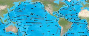
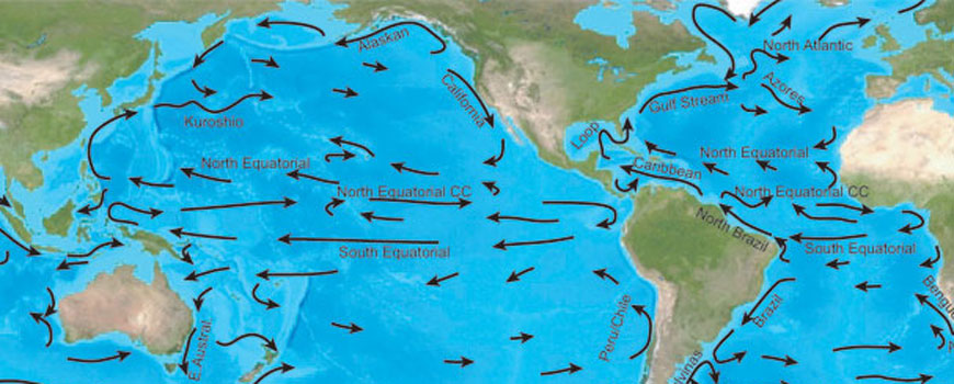
The equatorial currents of the Pacific.
Image: NOAA
by Rick O'Connor | Jun 3, 2021
With this article we are going to begin a short series on the biogeography of panhandle vertebrates. Biogeography is the study of distribution of life and why species are found where they are. Many are interested in what species are found in a specific location, such as which sharks are found in our area, but understanding why others are not is as interesting.
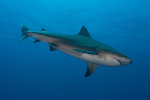
The Bull Shark is considered one of the more dangerous sharks in the Gulf. This fish can enter freshwater but rarely swims far upstream. Photo: Florida Sea Grant
All species have a point of origin and from there they disperse across the landscape, or ocean, until they reach a barrier that stops that dispersal. These barriers can be something physical, like a mountain range, something climatic, like the average temperature, or something biological, like to abundance of a specific food or predator. There are a lot of barriers that impede dispersal and explain why some species are not present in some locations.
Sharks are marine fish. In general, there is little to impede the dispersal of marine fish. All oceans are connected and there is no reason why a shark found in the Gulf of Mexico could not swim to Australia, and some have. But there are barriers that keep some species of south Florida fish from reaching north Florida – mean water temperature being one.
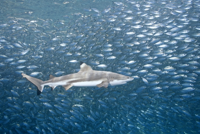
There are 24 species of sharks from nine different families found in the Gulf of Mexico. Most have a wide distribution range, and some are found worldwide. Nurse sharks are more tropical, common in the Keys, but are found in our area of the northern Gulf of Mexico. They are fans of structure and are often found near our artificial reefs.
Whale sharks and hammerheads are circumtropical, meaning they are restricted by water temperature but found worldwide in warmer waters. Whale sharks are the largest of all fish, reaching a mean length of 45 feet, and are not common near shore. They are plankton feeders and, though large, are harmless to humans. There are five species of hammerheads found in the Gulf of Mexico. They are easily identified by their “hammer” shaped head and are known for their large dorsal fin that, at times, will extend above the surface while they are swimming. Finding species of hammerhead inside the bay is not uncommon.
Several of our local sharks are not as restricted by water temperature and are found as far north as Canada. Sand tigers, threshers, and dogfish seem to prefer the cooler waters and, though found in the Gulf, are not common. There are two members of the mackerel shark family found here. Great whites, of movie fame, prefer cooler waters and are found worldwide – except for polar waters. There are records in the Gulf, but most are offshore in cooler waters. As you know, these are large predatory sharks, reaching up to 25 feet in length, and are known to feed on large prey such as seals. Their cousin the shortfin mako, prefers warmer waters and is more common here. Nearshore encounters with makos is rare but has happened.
The largest family, and best known, are the requiem sharks. There are 13 species in the Gulf, and many are common in our area. Many are not as restricted by water temperature and can be found as far north as New York. Bull sharks are not restricted by salinity and have been found up rivers in Alabama, and Louisiana. Silky sharks are more tropical, and the tiger and spinner sharks are more circumtropical.
The geographic distribution of sharks seems centered on water temperature. Most can easily swim the oceans to locations across the globe but congregate in areas of preferred temperatures and food. Though feared because of attacks on humans, a rare thing actually, they are fascinating animals and world travelers.
by Carrie Stevenson | May 7, 2021

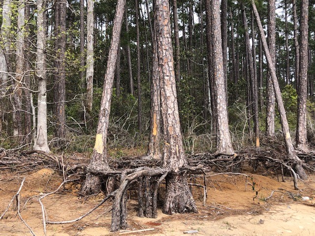
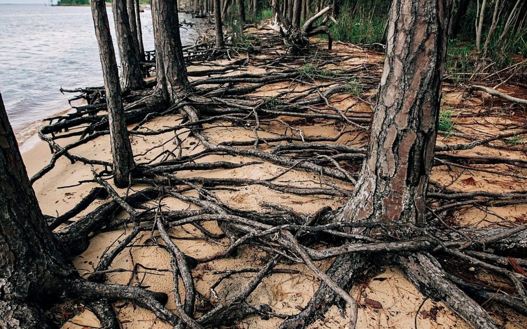
A ghost forest forming along the shoreline of Blackwater Bay in Santa Rosa County. Photo credit: Carrie Stevenson, UF IFAS Extension
As the name implies, they are haunting—wide stretches of standing, dead trees with exposed roots. These “ghost forests” are an unsettling scene in unsettling times for the environment. While coastal erosion is a fact of life—incoming waves, hurricanes, longshore drift of beach sand—the rate of its occurrence is startling lately.
Global rises in sea level due to increased atmospheric carbon levels mean more saltwater is moving into flat, coastal habitats that once served as a buffer from the open water. Salt is an exceedingly difficult compound for plants to handle, and only a few species have evolved mechanisms for tolerating it. Low-growing salt marshes and thick mangrove stands have always served as “first line of defense” buffers to take in wave action and absorb saltwater. If shorelines have too much wave action for marshes to form, wide stretches of sandy beach and dunes serve the same function, protecting the inland species of shrubs and trees. Many coastal areas are flat and stay at or just above sea level for thousands of yards, or even miles. This means that even a small increase in sea level can send saltwater deep into previously freshwater systems, drowning the marsh and flooding stands of oak and pine. The salt and sulfate in seawater will kill a tree quickly, although it may remain standing, dead, for months or years. Hurricanes and tropical storms exacerbate that damage, scouring out chunks of shoreline and knocking down already-unstable trees.

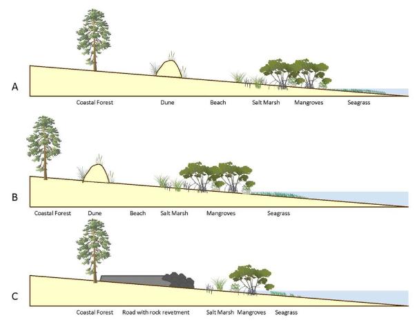
This diagram outlines the changes in coastal vegetation and shorelines as sea level rises. With “ghost forests,” the sea level moves into that coastal forest section. Figure credit: W. Gray, IAN Image Library
A slow increase in sea level could be tolerated and adapted to as salt marshes move inland and replace non-salt tolerant species. But this process of ecological succession can be interrupted if erosion and increased water levels occur too quickly. And if there is hard infrastructure inland of the marshes (like roads or buildings), the system experiences “coastal squeeze,” winnowing the marsh to a thin, eventually nonexistent ribbon, with no natural protection for that expensive infrastructure.
Ghost forests are popping up everywhere. Earlier this month, Popular Mechanics magazine reported on a recently published study that used satellite imagery to document how 11% of a previously healthy forest was converted to standing dead trees along the coast of North Carolina. The trees died within a span of just 35 years (1984-2019). During that time frame, this stretch of coastline also experienced an extended drought and Category 3 Hurricane Irene. These impacts sped up the habitat loss, with over 19,000 hectares converted from forest to marsh and 1100 hectares of marsh vegetation gone, becoming open water.

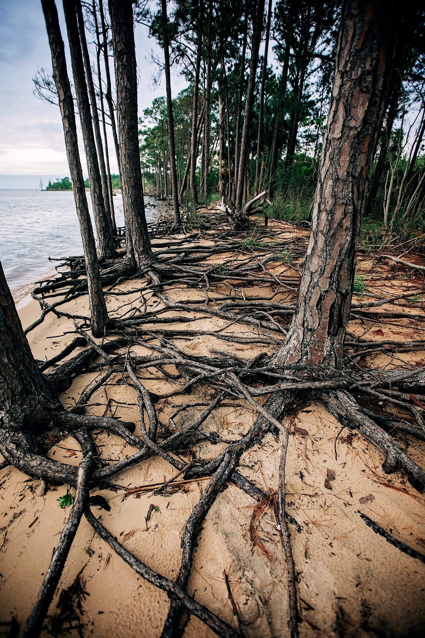
Exposed roots of a ghost forest forming along the Escambia Bay. Photo credit: Deanie Sexton
Due to increased coastal flooding and saltwater standing in forested areas, U.S. Fish and Wildlife Service employees are concerned that the historic Harriett Tubman Byway in Maryland—part of the famed underground railroad of the Civil War era—will soon be gone. Over 5,000 acres of tidal marsh have converted to open water in the area and large stands of trees have died. Even locally, trees along Escambia and Blackwater Bay are dying due to salt damage and heavy erosion. Hurricane Sally delivered a knockout punch to many remaining trees along the scenic bluffs of the bay.
Sea level has risen over 10” in the past 100 years in the Pensacola Bay area, and even mid-range Army Corps of Engineers estimates expect 0.6 to 1.4 feet of rise in the area by 2045. There are some actions we can take to mitigate future damage. Building a “living shoreline” of vegetation along a piece of waterfront property instead of using a seawall can help, especially if the vegetation growth outpaces sea level rise. You can also visit the City of Pensacola’s Climate Task Force report to learn more about climate action recommended (and being taken) locally, such as increasing the use of renewable energy and dedicating staff to sustainability measures.